Thunder Mountain Scramble
View Photos
Thunder Mountain Scramble
Difficulty Rating:
Thunder Mountain is an excellent beginner to intermediate scramble in the Crowsnest region. This is a great choice if you are driving down from Calgary or making your way north from Crowsnest or Waterton. The trail is easy to follow and isn’t too challenging. The views are astounding from the summit, and making your way down is simple.
Getting there
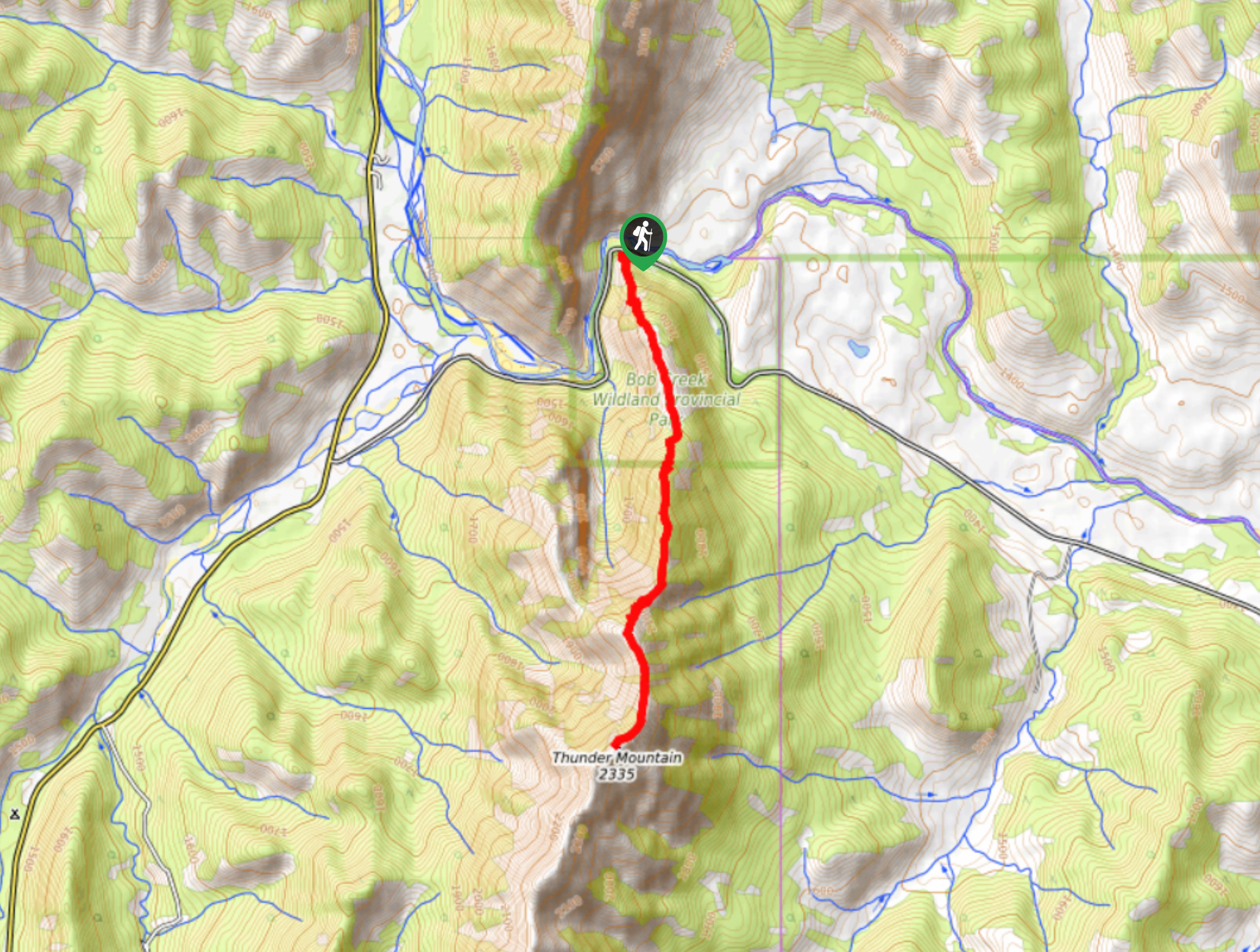
To get to Thunder Mountain trailhead, take Highway 3 eastbound from Crowsnest towards Lundbreck. Turn onto AB-22 N and follow this until you reach the Maycroft Provincial Recreation Area. Turn left onto Township Road 101A. Stay on this road for 11.1mi and pull over on the left side at a sharp bend in the road. You will be across from Old Man River when you pull over.

About
| When to do | May-September |
| Backcountry Campsites | No |
| Pets allowed | Yes |
| Family friendly | No |
| Route Signage | Poor |
| Crowd Levels | Moderate |
| Route Type | Out and back |
Thunder Mountain Scramble
Elevation Graph
Weather
Thunder Mountain Scramble Description
From the pullout, look for an old skid road on the side of the highway. The trail starts by gaining some elevation along this dirt road and making its way up the slope. The trail can be steep at first and then arrives at a nice plateau. Not many views appear from here, but you can see the next section of trail ahead of you including the false summit. Some cliff sections are in the line of sight, so pay attention before beginning the scramble segment.
The trail follows the ridge up a few cliff bands and continues up to the false summit where the true summit ridge is revealed. The scramble sections are short and perfect for intermediate scramblers. After reaching the false summit, you will be greeted with an easy ridge traverse to the true summit. There is some loose rock on the way that may be slippery. Once you get to the true summit, you will be able to see the surrounding peaks and valleys all around. The Old Man River is easily visible below the summit. Making your way down is simple, and the scramble sections aren’t too challenging.
Similar hikes to the Thunder Mountain Scramble hike
Trail of Seven Bridges
The Trail of Seven Bridges is more popular with OHV users as it is a multi-use trail. You will run…
Yarrow Ridge
Yarrow Ridge is a stunning double lollipop loop that leads up a cutline to a ride. The ridge features various…
South Fork Lakes Trail
The trail to South Fork Lakes is easy to find and requires a river crossing almost immediately. The trail follows…
Comments