Col de Borneronde Hike
View PhotosCol de Borneronde Hike
Difficulty Rating:
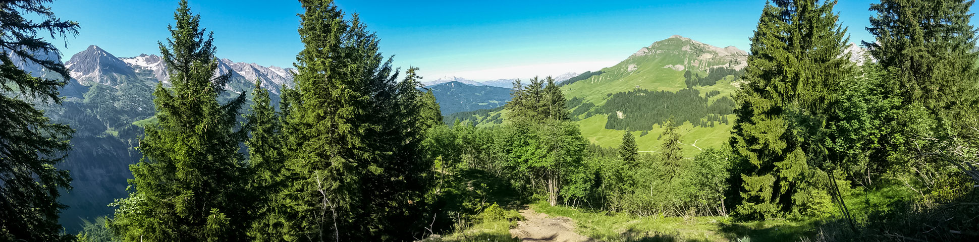
If you’re looking to escape the crowds and the harsh summer sun, head to the Bois de la Duche forest near the Col des Annes. This shady forest is dappled with soft sunlight and has a wide range of fauna and views to enjoy along the way. This hike takes you to the Col de Borneronde, where you can choose to add further tracks and circuits in less wooded areas if this circuit is too short.
Getting there
Tucked away in a remote valley, the easiest way to get to the beginning of this hike at the Bois de la Duche is by car. Local buses run from Le Grand Bornand during the summer months, but they only go as far as the golf course, adding an extra hour in both directions to walk on a sealed road. Cows are herded along this narrow, winding road, so drive with caution.

About
| When to do | May - October, depending on snow |
| Backcountry Campsites | No |
| Toilets | No |
| Family friendly | Yes |
| Route Signage | Good |
| Crowd Levels | Low |
| Route Type | Circuit |
Col de Borneronde Hike
Elevation Graph
Weather
Route Description for Col de Borneronde Hike
Start from the La Duche car park just below the bar and restaurant with the same name. Turn to face downhill to take the signposted, wide gravel track by the chalet. After a bend in the track, you will see a river in front of you. Take the heavy wooden bridge on the left to avoid having to cross the wet, slippery rocks.
Follow the track, which veers to the right and up the hill into the forest. Around 328ft along the trail, there is a signpost where you can choose to take the reverse, clockwise circuit to the Col de Borneronde. Clockwise, the ascent is more consistently uphill, with a longer, more varied descent.
The anti-clockwise route described in this post, has a gentler, longer ascent with small sections of flat or downhill tracks, then a shorter, steeper descent which is still easy enough for beginner hikers or those without hiking poles. For the anti-clockwise hike to the Col de Borneronde, take the trail on the right.
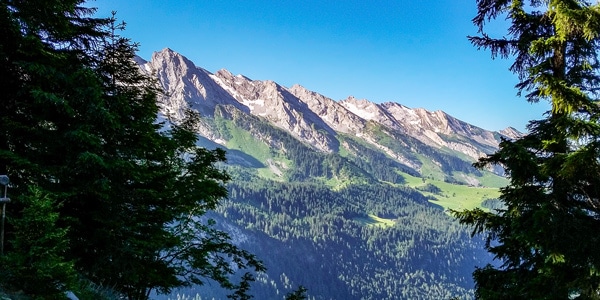
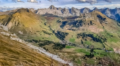
Follow the signs to the Sur le Saix lookout point. Close to the lookout point, the constant ascent flattens and there are some logs cut into seats to sit and rest, if required. From the lookout point, take in the views overlooking the Aravis chain of mountains, including Pointe Percée.
To continue the hike, retrace your steps for 328ft, where the sign post indicates the direction for the Col de Borneronde. Follow the sign towards the col, where the track becomes steeper and rockier.
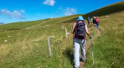
As the path narrows, the trees thin out and blueberry bushes cover the ground. Carry on along the trail, past ornate broken tree trunks and scenic views on both sides of the track as you hike up the wide crest.
At the top, there is a lookout point on the left. Keep your eyes peeled for ibex and other wildlife along the distant ridge. Continue down the track, where shrubs with flowers replace the blueberry bushes. A little further on, before the Col de Borneronde, a picnic table in the shade makes the perfect spot for lunch.
As you approach the col, the scenery changes once more, with open fields of wildflowers between the forest sections. At the col, you can choose to continue hiking further afield or complete the circuit back to the Bois de la Duche, following the signs at the col and taking a sharp left down the hill, past wild strawberry plants on both sides of the trail.
The track winds under the Col des Annes chairlift, passing through open fields, woods, and the odd stream. To the right, you might spot the small chapel in the distance between the trees.
After a final steep descent, you’re back at the first crossroad of the circuit, around 328ft from the river with the wooden bridge. Turn right to return to the river, where you might like to dip your feet in the ice-cold snow melt from higher up. The car park is just a short walk from here, giving you the chance to cool down on a hot day before you drive away.
Insider Hints
This is a wonderful hike for families, but do be aware that the safety barriers at the lookout points are easy for kids to climb under or simply don’t exist.
The hike is not suitable for wheelchairs or pushchairs.
Go late in the summer if you wish to collect wild blueberries.
A nice addition to this hike is to take the short trail to the Col des Annes, where there is a summer dairy farm where you can buy cheese and a restaurant and bar for a mid-hike refreshment.
For a much longer hike, take the circuit to the Col de l’Oulettaz from the Col de Borneronde, which returns to the Col de Borneronde.
The La Duche restaurant and bar by the car park is open during the peak summer months and offers good-quality, traditional meal options. You can also use the bathroom here (if you’re a customer).
Bring binoculars to get a better view of the surrounding ridges, where wildlife can often be spotted (particularly when there’s still snow).
Similar hikes to the Col de Borneronde Hike hike
Lac du Mont Charvin
It would be easy to overlook this hike on face value: the lake is small and green; the starting point…
Mont Baron
Mont Baron offers a sweeping 360° vista, with Lake Annecy to the west and the foot of the Alps to…
Lac de Lessy
Lac de Lessy is a classic place for wildlife spotting, and it’s well known for the loud calls of stags…
Comments