
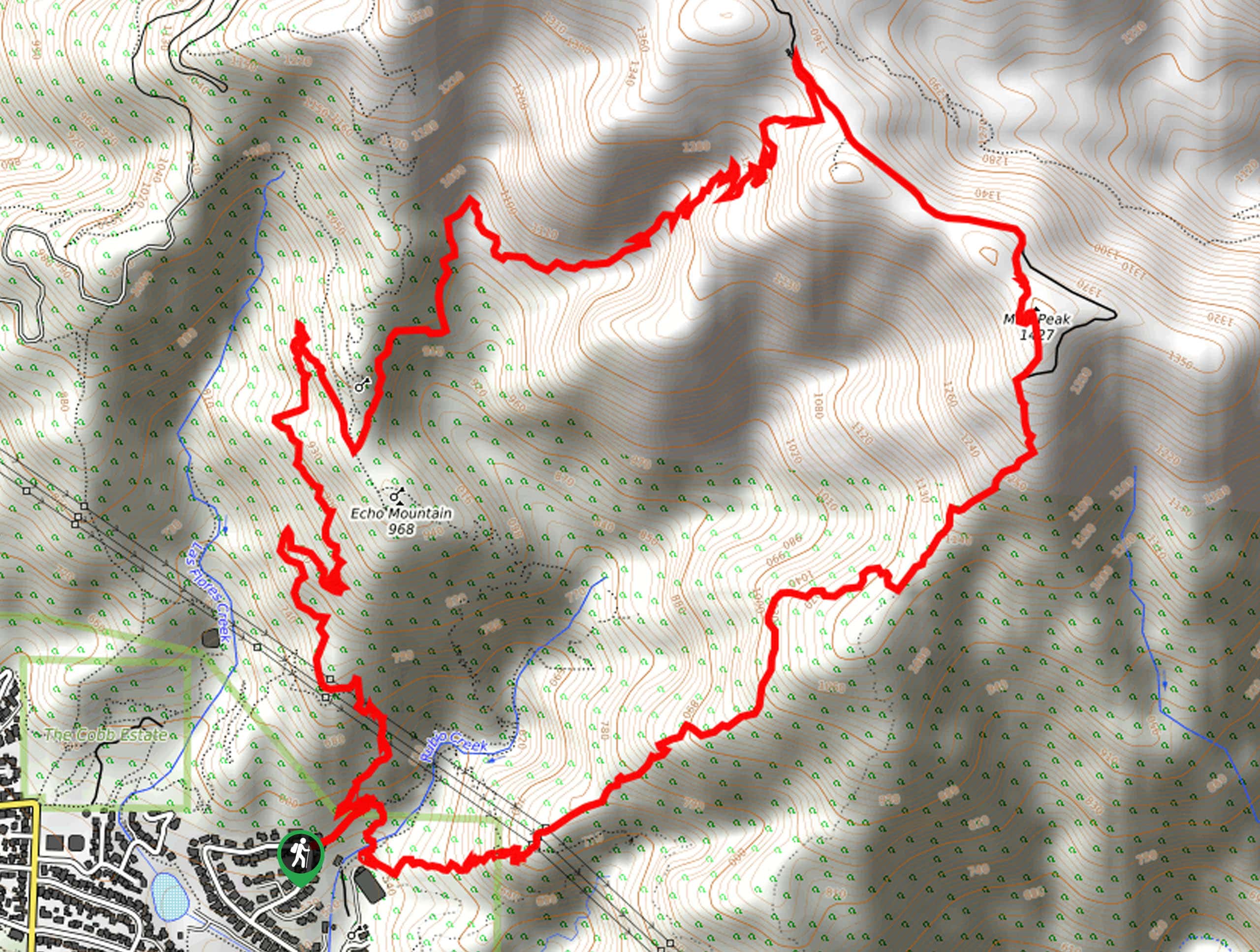
Muir Peak Loop Trail
View Photos
Muir Peak Loop Trail
Difficulty Rating:
Hiking the Muir Peak Loop Trail is an epic adventure in Southern California that will see you traverse some rugged terrain for beautiful views. While out on the trail, you will climb uphill into the mountains to reach Inspiration Point, before continuing on to the top of Muir Peak. Make sure to have your adventure pass visible in your car prior to setting out on your hike.
Getting there
The starting point for the Muir Peak Loop Trail can be found on Pleasant Ridge Drive in Altadena, CA.

About
| Backcountry Campground | No |
| When to do | Year-Round |
| Pets allowed | Yes - On Leash |
| Family friendly | Older Children only |
| Route Signage | Average |
| Crowd Levels | Moderate |
| Route Type | Lollipop |
Muir Peak Loop Trail
Elevation Graph
Weather
Muir Peak Loop Trail Description
For those hikers who don’t mind putting in a bit of hard work for their views, the Muir Peak Loop Trail is an awesome option to explore in the Angeles National Forest.
Setting out from the trailhead, you will initially head northeast into Rubio Canyon, before turning to the north to traverse the slopes of Echo Mountain. After passing by the ruins of the Mount Lowe Observatory, the trail will turn back to the northeast and continue on to Inspiration Point.
From here, you will follow the One Man & Mule Trail to the southeast, where you will eventually arrive at the summit of Muir Peak for some amazing views. After reveling in the scenery, follow the trail as it descends to the southwest into Rubio Canyon before arriving back at the trailhead.
Similar hikes to the Muir Peak Loop Trail hike

Mount Zion via Lower Winter Creek Trail Loop
The Mount Zion via Lower Winter Creek Trail Loop is a physically demanding Southern California adventure that features waterfall and…

Sunset Peak Alternate Approach Hike
The Sunset Peak Alternate Approach Hike is a great intermediate-length route in Southern California that features some gorgeous canyon views.…
Register Ridge to Mount San Antonio Hike
The Register Ridge to Mount San Antonio Hike is equal parts scenic and incredibly challenging. While out on the trail,…
Comments