
New Fork Trail
View Photos
New Fork Trail
Difficulty Rating:
The New Fork Trail explores a gorgeous swathe of wilderness abundant with a diversity of flora, and a meandering creek adorned with idyllic swimming holes. Those who desire a secluded adventure in the Wind River Range will likely enjoy this enchanting adventure.
Getting there
The New Fork Trail departs from the trailhead off the New Fork Lake Road.

About
| Backcountry Campground | Backcountry Camping |
| When to do | May-October |
| Pets allowed | Yes - On Leash |
| Family friendly | Older Children only |
| Route Signage | Average |
| Crowd Levels | Moderate |
| Route Type | Out and back |
New Fork Trail
Elevation Graph
Weather
New Fork Trail Description
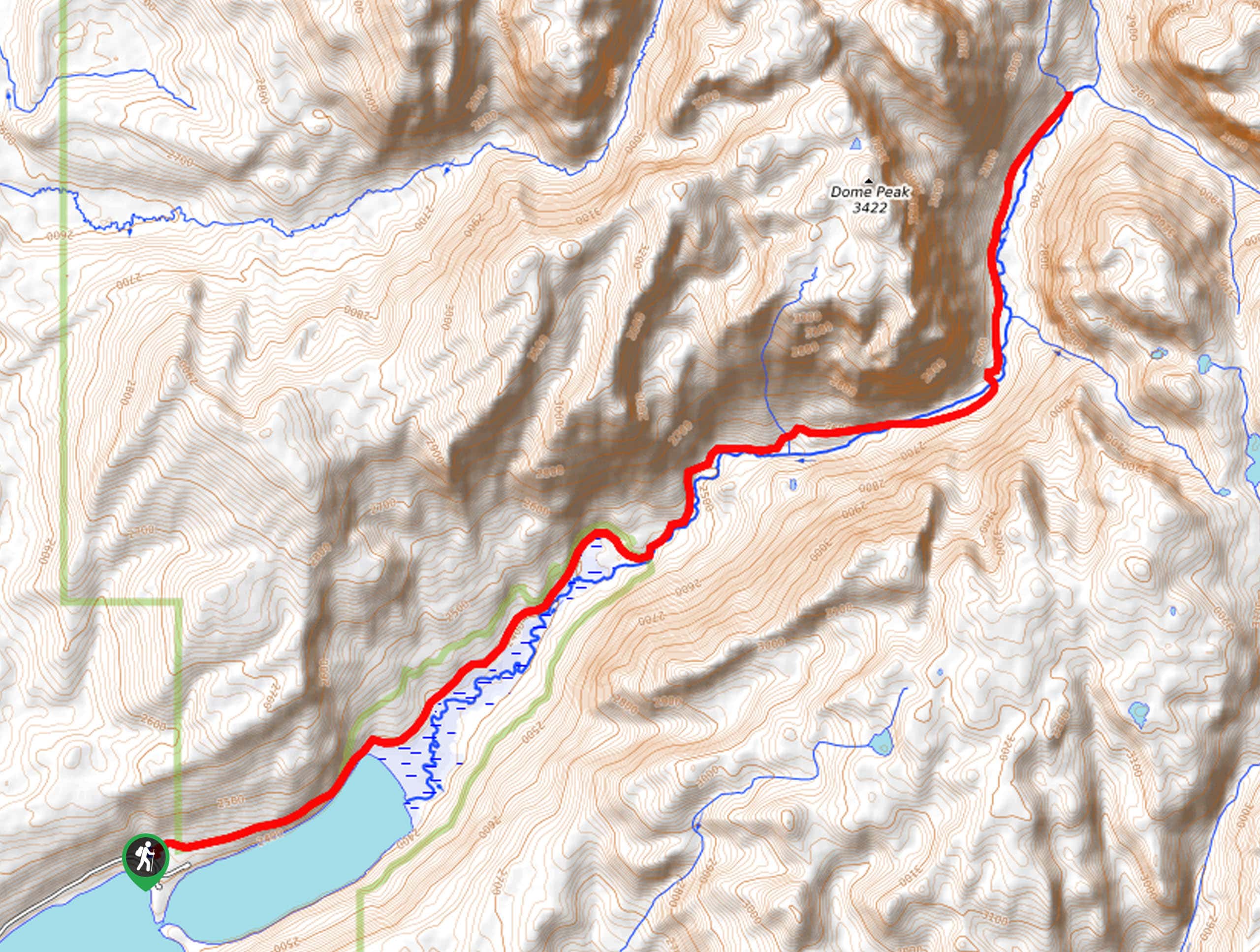
The New Fork Trail boasts breathtaking scenery. Explore lakeshores, canyons, creeks, and meadowlands, then take a swim in refreshing swimming holes on this trek. While this route offers wonderful scenery, it is worth noting that the hike does not provide the best views of the mountains, though the craggy-bound corridor is quite picturesque. Note the trail is overgrown and rocky in sections, as well as it demands creek crossings, so come prepared to do some scrambling. As with all sorts of exploration in the area, we encourage hikers to bring bear spray in the unlikely case of an encounter.
Embark on your adventure along the New Fork Trail from the trailhead off the New Fork Lake Road. Setting out from here, the New Fork Trail traces the shoreline of New Fork Lake, a shimmering, picture-perfect pool. Following the New Fork Trail, the path will eventually divert away from the lakeshore and along the meandering creek. Traveling through abundant wildflower meadows and sparse tree stands, the path’s incline will increase in intensity, warranting a bit of a sweat. Climbing through the canyon, you will notice Dome Peak looming above the valley on the left and Doubletop Mountain on your right-hand side.
The grandeur of the bounding granite walls will render you speechless. You will ultimately reach the trail’s end at the intersection with Dodge Creek. Marvel at the beauty of the encompassing landscape, then retrace your steps along the path back to the trailhead.
Similar hikes to the New Fork Trail hike
Glacier Trail
The Glacier Trail is a demanding day hike in the Winds that boasts a scenic and secluded experience. Wander through…
Sheep Bridge Trail
The Sheep Bridge Trail checks all the boxes—short, scenic, and secluded. What more could you ask for? Mountain views? It…
Francis Lake Trail
The Francis Lake Trail is a great hike worth the detour into the Winds. While this area is extremely popular,…
Comments