
Indian and Wolf Trails
View Photos
Indian and Wolf Trails
Difficulty Rating:
The Indian and Wolf Trails are an epic network of routes into the backcountry. Explore mixed-pine woodlands and lush montane meadows that offer breathtaking views of the Wind River Mountains. Just a few steps away from Lander, Wyoming, this adventure is popular amongst hikers and mountain bikers alike seeking a weekend wilderness escape.
Getting there
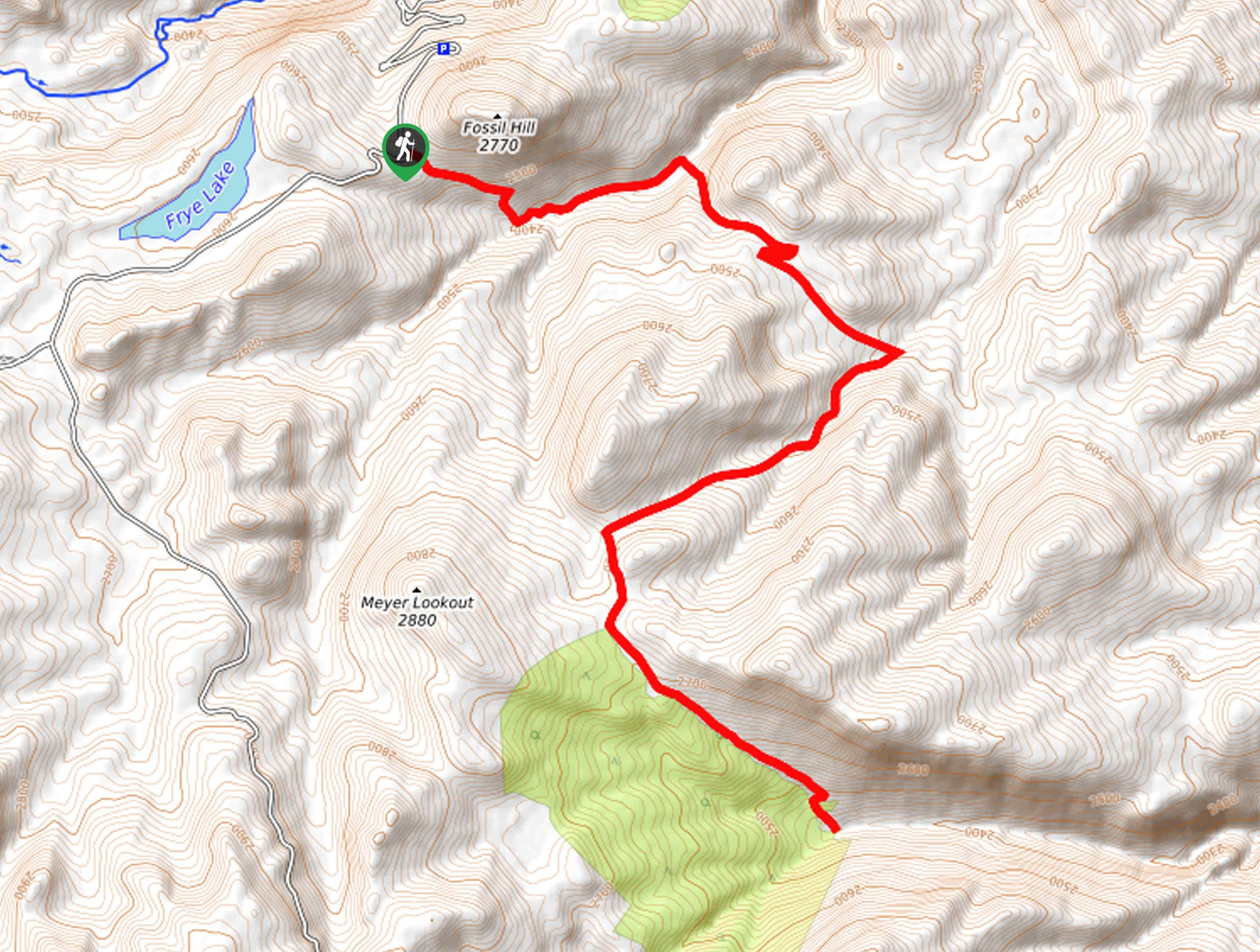
The Indian and Wolf Trails Hike departs from Fossil Hill Trailhead off Louis Lake Road.

About
| Backcountry Campground | Backcountry Camping |
| When to do | April-October |
| Pets allowed | Yes - On Leash |
| Family friendly | No |
| Route Signage | Average |
| Crowd Levels | Low |
| Route Type | Out and back |
Indian and Wolf Trails
Elevation Graph
Weather
Indian and Wolf Trails Description
Hiking the Indian and Wolf Trails makes for an unforgettable experience. A hidden gem in the southern Winds River Mountains, this route yields a tranquil experience and wonderful wildlife viewing opportunities. As with all sorts of exploration in the area, it is important to be mindful of bears. While an encounter is unlikely, we encourage hikers to bring a can of bear spray just in case!
Additionally, as this route is shared with bikers, be mindful of passers-by as well as rocks and roots that obstruct the path. Note there are some steep segments along this route, so come prepared for some calf-burning climbs!
Boasting incredible views of the Wind River Mountains and the Sinks Canyon, this route offers countless photo opportunities, so make sure your camera is charged! Get a wonderful workout along this undulating route as you explore several creeks nestled amongst ridges and rocks. Though this route is open year-round, we encourage you to head out in the spring when the vegetation is lush, the meadows blossom with wildflowers, but the mountaintops maintain a picturesque dusting of snow. So conveniently located near Lander, this route sees the most traffic on the weekend when families head out into the wilderness.
Embark on your adventure along the Indian and Wolf Trails from the Fossil Hill Trailhead off Louis Lake Road. Setting out from here, follow the Wolf Trail east, continuously descending through the exposed meadowlands. Right off the bat, you will be granted awesome views of the Winds, including sights of intrepid explorers scaling the rugged cliffsides of Fossil Hill. Soon after your departure from the trailhead, the path will dip beneath the forest canopy and over Sawmill Creek. From here, the Wolf Trail will climb out of the canyon and behind Indian Ridge.
When you ultimately reach an intersection with Trail 363, keep right and hike southeast along the backside of the ridge. Again, dipping down into a wooded canyon, you will reach Elderberry Creek, turn right, and you will be directed west up to Indian Ridge. The exposed terrain warrants wonderful views of the Winds’ majestic granite ridges in the northwest and Meyer Lookout towering above. Admire the scene, then take the leftmost branch of the Indian Trail, heading south.
Beyond this point, the path will again begin to descend, giving your legs a well-deserved break from the climbing! Mine your footing on the uneven terrain and keep an eye out for wildlife as you progress further into the backcountry. Retreat beneath the tree canopy to escape the heat as needed, and the Indian Trail will eventually lead you to Spring Creek. Filter your water bottle before beginning your return back to the trailhead. While this route continues into the wilderness, we turned around here, though if time permits or you are backcountry camping, we encourage you to explore further! When you are set to head back, simply retrace your footing along the path back to the parking lot.
Trail Highlights
Meyer Lookout
Located in the southern Wind River Mountain Range, is the Meyer Lookout. Rising above Sinks Canyon, this small mountain sits at an elevation of 9449ft along the Indian Trail.
Insider Hints
Take a trip along the Sinks Canyon Trail after your adventure
Be mindful of rocks and roots obstructing the path
Be bear aware—make sure at least one person in your group carries bear spray
This route is shared with bikers, so be mindful of passers-by
Wear SPF much of the route is exposed
Bring a water filter to fill up your water bottle along the way
Charge your camera, the views of the mountainscape are breathtaking
Similar hikes to the Indian and Wolf Trails hike
Glacier Trail
The Glacier Trail is a demanding day hike in the Winds that boasts a scenic and secluded experience. Wander through…
Sweeney Creek Trail
The Sweeney Creek Trail can be enjoyed in a myriad of different ways. This epic expedition into the high country…
Section Corner Lake Trail
The Section Corner Lake Trail exemplifies the beauty and grandeur of the Wind River Mountain Range. Somewhat of a hidden…
Comments