
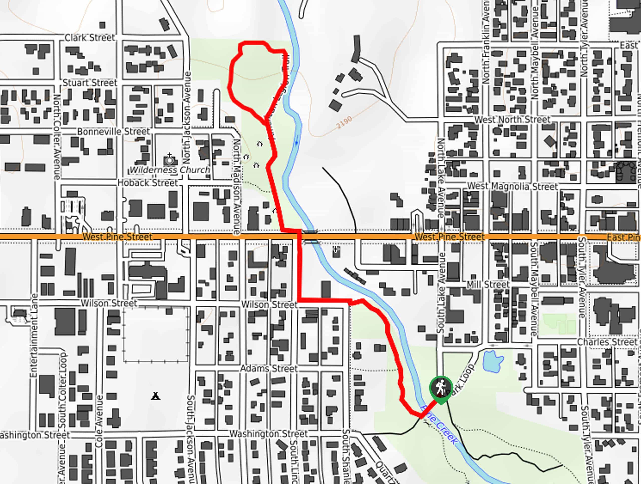
Boyd Skinner Trail
View Photos
Boyd Skinner Trail
Difficulty Rating:
The Boyd Skinner Trail is the perfect urban escape. Boasting a pleasant and easy experience, this lovely path travels through a vibrant greenspace that exhibits a diversity of flora and fauna within the town’s limits.
Getting there
The Boyd Skinner Trail is accessed from Park Loop Road.

About
| Backcountry Campground | No |
| When to do | April-October |
| Pets allowed | Yes - On Leash |
| Family friendly | Yes |
| Route Signage | Average |
| Crowd Levels | Moderate |
| Route Type | Lollipop |
Boyd Skinner Trail
Elevation Graph
Weather
Boyd Skinner Trail Description
The Boyd Skinner Hike is ideal for families with young children or those simply seeking a relaxing nature walk without having to leave the town’s limits. Wander through lush grasslands, and pine tree stands carpeted with seasonal wildflowers along this route. While this route is located near civilization, deer and moose are often spotted here. Note that much of the path is unshaded, so wear SPF and bring plenty of water on a sunny day.
Taking the rightmost trail signposted for the Boyd Skinner Trail, you will be led into the grasslands and over Pine Creek. After crossing the stream, you will confront an intersection, turn right here, and you will be redirected northwardly, running parallel to Pine Creek. After some hiking, the path will intersect with W Pine Street. Here, you will merge onto the American Legion Trail, which will loop you through the American Legion Park.
Once you complete the loop, retrace your steps back onto the Boyd Skinner Trail. Retrace your steps along this route all the way back to the trailhead.
Similar hikes to the Boyd Skinner Trail hike
Upper Brewers Trail
The charm of a one-way trek is unrivaled. Enjoy new scenery every step of the way as you hike the…
Dubois Recreation Area Scenic Overlook Hike
The Dubois Recreation Area Scenic Overlook Hike is an epic adventure that explores the painted hills. Located just outside the…
Downtown Dubois Walk
While not technically a hiking route, the Downtown Dubois Walk is a great adventure. Many people visiting the Winds or…
Comments