
Island Lake Trail
View Photos
Island Lake Trail
Difficulty Rating:
The Island Lake Trail is a gorgeous hike in the Western Uintas. This trail travels through the Uinta Lake Country, an area with countless pristine alpine lakes. For moderately experienced hikers or beginners looking for a challenge, the Island Lake Trail is a fantastic day hike or overnight backpacking destination.
Getting there
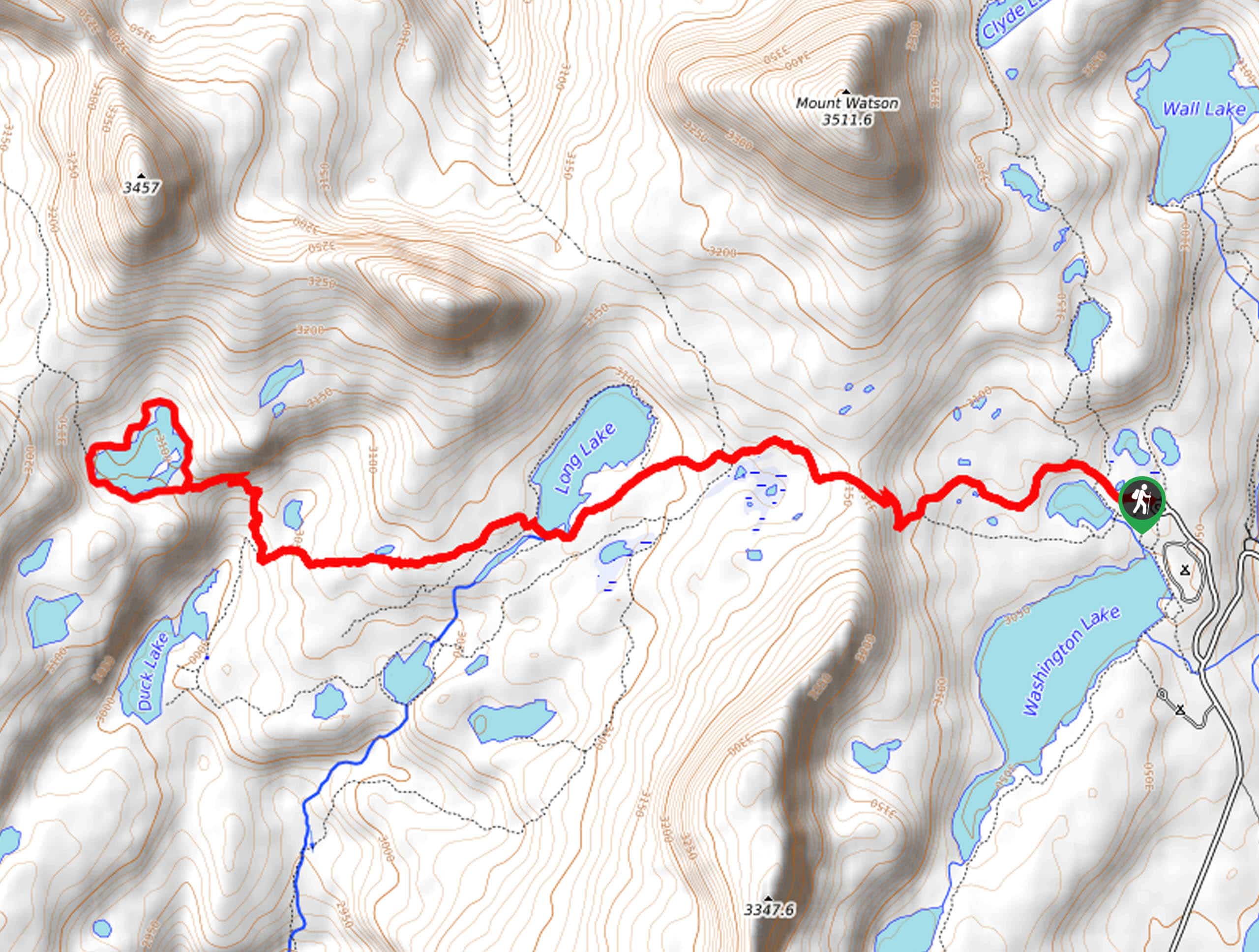
From Kamas, Utah, head east along highway 150 for 24.6mi then take a left onto Forest Road 041. Continue along FR 041 to a divide, take a right then park at the Crystal Lake Trailhead parking lot just past the Washington Lake Campground. The Island Lake Trail begins here.

About
| Backcountry Campground | Washington Campground, Camping at Island Lake and Long Lake |
| When to do | June to October |
| Pets allowed | Yes |
| Family friendly | Older Children only |
| Route Signage | Average |
| Crowd Levels | High |
| Route Type | Lollipop |
Island Lake Trail
Elevation Graph
Weather
Island Lake Trail Description
The Island Lake Trail is a fantastic route in the Western Uintas. This trail can get buggy in the early summer. If you are hiking in late June or early July, be sure to bring along bug spray or wear long layers to combat the mosquitoes. Mosquitoes aren’t the only wildlife you’ll see on this trail; the Island Lake Trail is a prime place to see moose, songbirds, and waterfowl who live in the area. If you are hiking with a dog, be sure to keep your eye out for wildlife and keep a leash on hand in case of wildlife encounters.
The Island Lake Trail is popular, and it’s popular for a reason. With opportunities for fishing, camping, and cliff jumping at Island Lake itself and so much to explore along the way, this trail truly has so much to offer. The Island Lake Trail really is the perfect place to spend some quality time enjoying the beauty of the Utah wilderness with friends, family, and pups.
To get to Island Lake, begin at the Crystal Lake Trailhead. From the trailhead, follow the Lakes Country Trail 216 west along the north shore of Crystal Lake. Approximately 2.6mi from the trailhead, the path will fork, take the middle path to hike along the south shore of Long Lake. At the southwestern corner of Long Lake, the trail will split; take the path on your right to continue west. Stay right at the next divide to hike the last section of the trail to Island Lake.
Enjoy your time relaxing, playing, and exploring at Island Lake. If you are feeling adventurous, check out the cliff jumps, or go for a swim in the frigid waters. When you are ready to head home, retrace your steps back to the Crystal Lake Trailhead, where you began.
Trail Highlights
Island Lake
Island Lake is a popular destination in the Uinta Mountains. This lake is a great place to swim, camp, and picnic. If you enjoy fishing, Island Lake is a good spot to fish for Brook Trout, Cutthroat Trout, and Rainbow Trout. For the thrill-seeker, Island Lake also has a spot for cliff jumping. The Island Lake Cliffs are 30ft–50ft tall, and, be warned; the water below is frigid; please exercise caution and enjoy responsibly.
Frequently Asked Questions
Can you swim in Island Lake, Utah?
Yes, the water is cold, but swimming is permitted in Island Lake.
Where is Island Lake in Utah?
Island Lake is located in the Western Uinta Mountains of Utah.
Insider Hints
The Crystal Lake Trailhead is the starting point for multiple popular hikes in the area. Arrive early to snag a parking spot, especially on weekends. If there is no parking left, there is an overflow parking lot about a mile down the road.
In the summer, this route is aburst with incredible wildflowers.
If you are looking for another route in the area, check out the 20 Lakes Trail.
Similar hikes to the Island Lake Trail hike

Willard Creek Waterfall Trail
The Willard Creek Trail is an adventurous yet beautiful hike on the eastern edge of Willard, Utah. This trail is…

Skull Crack Trail
Despite the foreboding name, the Skull Crack Trail is a fantastic hike in the Uinta-Wasatch-Cache National Forest. This trail follows…

Box Elder Creek Trail
The Box Elder Creek Trail is a lovely hike northeast of Salt Lake City. This trail is used by both…
Comments