Castle Peak Trail
View Photos
Castle Peak Trail
Difficulty Rating:
The Castle Peak Trail is a fantastic hike in the western Uintas. This trail is challenging and for experienced hikers only. Dogs are welcome to join you on your adventure up to Castle Peak, but must be kept on leash at all times.
Getting there
From Kamas, Utah, head east on highway 150 for 6.0mi and look for the Yellow Pine Trailhead on the north side of the road. The Castle Peak Trail begins here.

About
| Backcountry Campground | Yellow Pine Campground |
| When to do | May to October |
| Pets allowed | Yes - On Leash |
| Family friendly | No |
| Route Signage | Average |
| Crowd Levels | Low |
| Route Type | Out and back |
Castle Peak Trail
Elevation Graph
Weather
Castle Peak Trail Description
The Castle Peak Trail is a gorgeous hike just east of Kamas, Utah. This trail is challenging and should only be attempted by experienced hikers who are adept at scrambling. Dogs are welcome on this trail but, due to area wildlife, must be kept on a leash at all times. Please remember that this is a strenuous route that may not be appropriate for all pups. However, if you are up for the challenge, the Castle Peak Trail will reward you with a serious workout and absolutely incredible panoramic views of the surrounding Utah wilderness.
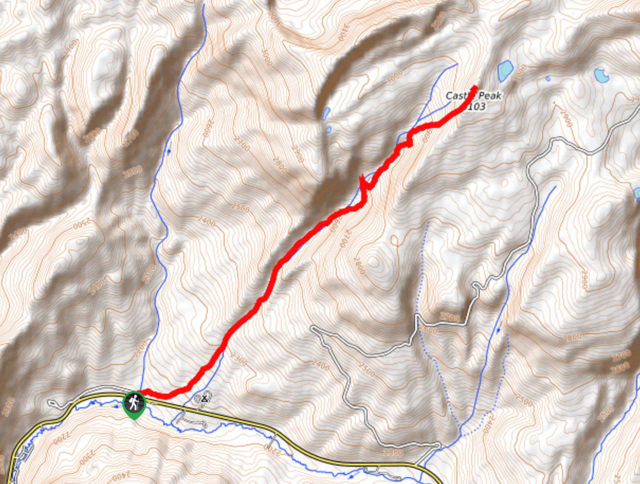
To hike to Castle Peak, begin at the Yellow Pine Trailhead on the north side of Highway 150. From the Yellow Pine Trailhead, follow the Yellow Pine Trail northeast along Yellow Pine Creek for approximately 3.4mi to a divide. At the divide, take the path on your right to continue northeast for about 0.3mi, then look for a spur trail on your left leading up to Castle Peak. Make your way up this trail until the path peters out, then choose your own adventure to climb to the top of Castle Peak.
At the summit, take a well-deserved rest and soak in the incredible views before turning around and retracing your steps back to the Yellow Pine Trailhead, where you began.
If you are looking for even more of an adventure, this hike can be extended along the Castle Lake Trail.
Similar hikes to the Castle Peak Trail hike

Willard Creek Waterfall Trail
The Willard Creek Trail is an adventurous yet beautiful hike on the eastern edge of Willard, Utah. This trail is…

Skull Crack Trail
Despite the foreboding name, the Skull Crack Trail is a fantastic hike in the Uinta-Wasatch-Cache National Forest. This trail follows…

Box Elder Creek Trail
The Box Elder Creek Trail is a lovely hike northeast of Salt Lake City. This trail is used by both…
Comments