
Tin Hat Mountain Hike
View Photos
Tin Hat Mountain Hike
Difficulty Rating:
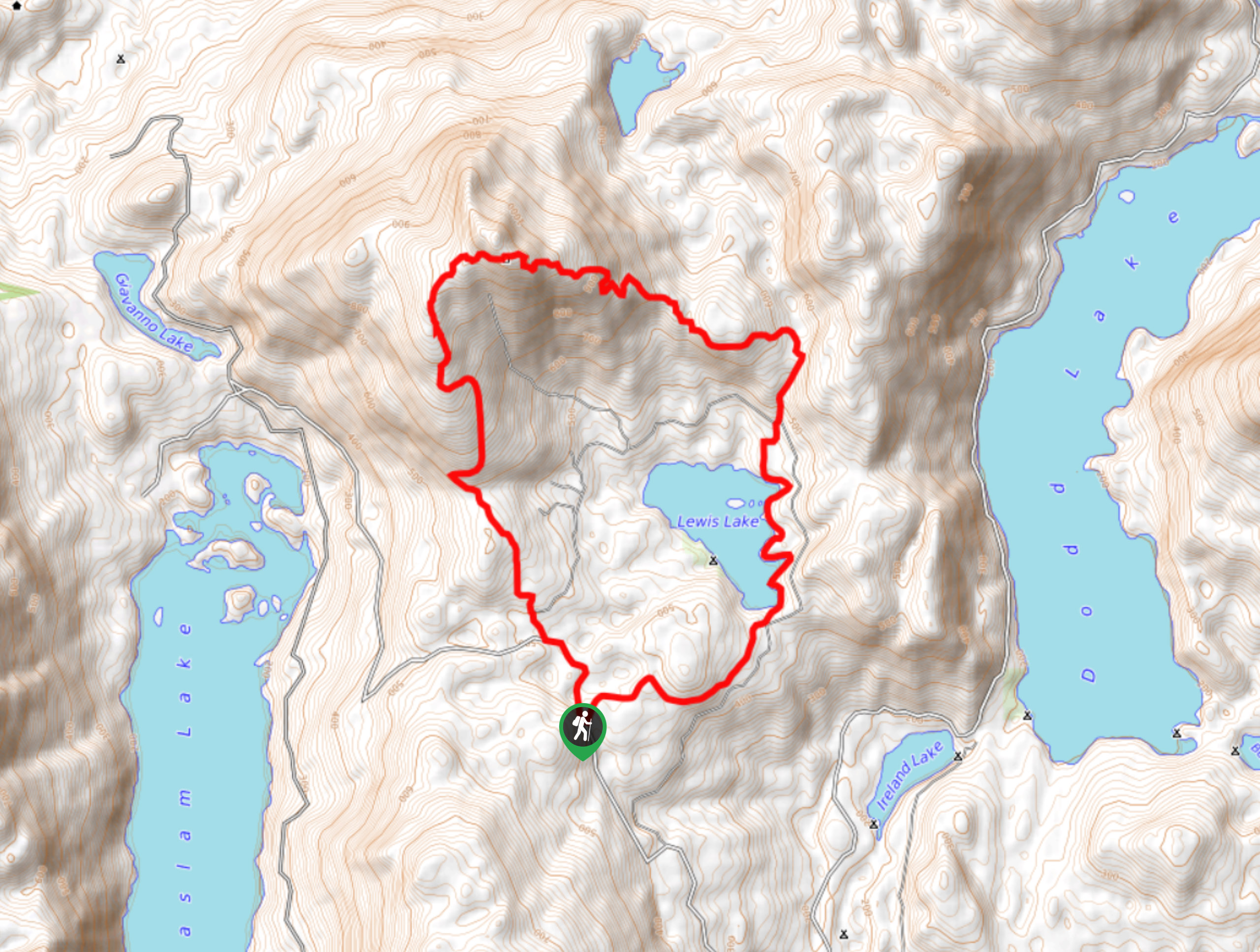
The Tin Hat Mountain Hike is an 11.4mi hiking circuit near Powell River, BC, that traverses a variety of terrain types on the way to the summit of Tin Hat Mountain. Along the trail, you will experience beautiful stretches of forest, open meadows, rocky terrain, and an amazing viewpoint from the summit that stretches across the Sunshine Coast. If you are looking to make this into a multi-day hike, you can deviate from the trail at the southern edge of Lewis Lake to reach the Lewis Lake Recreation Site.
Getting there
To reach the trailhead for Tin Hat Mountain from Powell River, drive south on BC-1012 for 11.2mi and turn left onto Dixon Road. After 2.4mi, make a slight left as the road becomes Goat Lake Mainline Road and follow it for 2625ft. Follow the road to the right and continue along for 8.0mi, where you will make a slight left. After 2.6mi, make another left, followed by a quick right. In 0.9mi you will arrive at the trailhead.

About
| When to do | May-October |
| Backcountry Campsites | Lewis Lake Recreation Site |
| Pets allowed | Yes |
| Family friendly | Older Children only |
| Route Signage | Average |
| Crowd Levels | Low |
| Route Type | Circuit |
Tin Hat Mountain Hike
Elevation Graph
Weather
Tin Hat Mountain Trail Description
The trek to Tin Hat Mountain is a fantastic hiking route with a moderate difficulty and longer overall distance, making it perfect for experienced outdoor enthusiasts, as well as casual hikers that are looking for a bigger challenge. The route sets out from the trailhead and enters into the thick cover of the forest to the east on a route towards Lewis Lake. Arriving at the picturesque wooded shores of the lake, continue around it in a counterclockwise direction, as you take in the intermittent views across the water. Reaching the northern end of the lake, follow the trail as it turns to the west and leads up a series of switchbacks to the summit of Tin Hat Mountain. Once there, you can enjoy the amazing views that overlook the Dodd, Haslam, and Powell Lakes, as well as countless mountain peaks. After taking in the views, follow the trail south as it works down a very rocky stretch of terrain on the return to the trailhead.
Similar hikes to the Tin Hat Mountain Hike hike

Malaspina Switchback Trail
The Malaspina Switchback Trail is a 4.3mi out-and-back hiking route in Powell River, BC, that will take you…

Holly Branch Loop Hike
The Holly Branch Loop is a 3.7mi lollipop hiking route near Powell River, BC, that will take you…

Stillwater Bluffs Trail
The Stillwater Bluffs Trail is a 1.9mi lollipop hiking route along the Sunshine Coast that provides some amazing…
Comments