
Hidden Homes Nature Trail
View PhotosHidden Homes Nature Trail
Difficulty Rating:
The Hidden Homes Nature Trail is a charming adventure near Colvis that the whole family can enjoy. Blow off some steam as you wander the perimeter of a grassy pond. This hike is ideal for those seeking a short but scenic adventure near the city.
Getting there
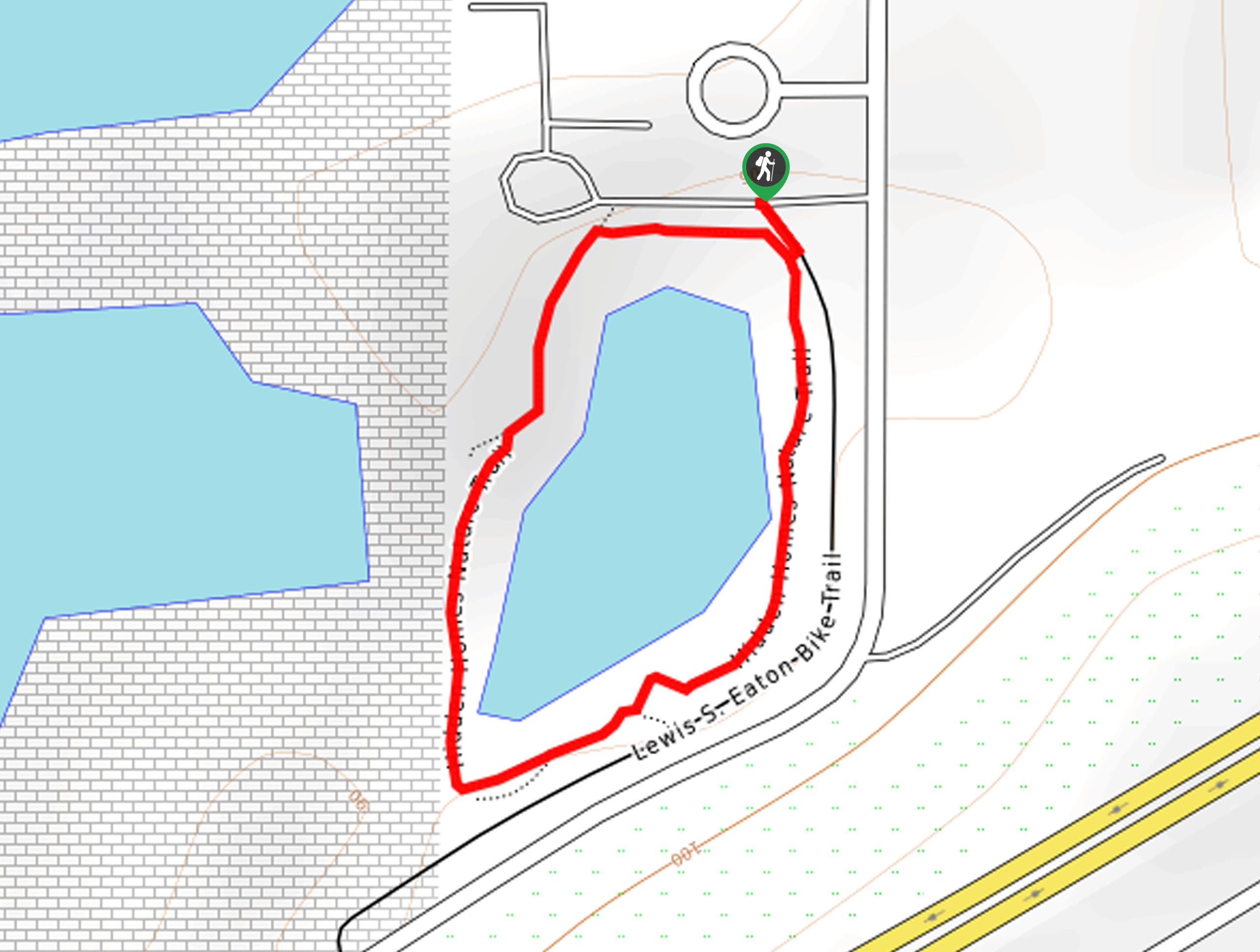
The Hidden Homes Nature Trail is accessed via the Lewis S. Eaton Bike Trailhead off Old Friant Road.

About
| Backcountry Campground | No |
| When to do | Year-round |
| Pets allowed | No |
| Family friendly | Yes |
| Route Signage | Average |
| Crowd Levels | Moderate |
| Route Type | Circuit |
Hidden Homes Nature Trail
Elevation Graph
Weather
Hidden Homes Nature Trail Description
Admire the area’s flora and fauna as you venture the Hidden Homes Nature Trail. This scenic trek around the pond boasts distant views of the foothills and Fresno. Wander the path whilst keeping an eye out for bunnies and lizards. Note the path is exposed, so be sure to wear sun protection in the summer months!
Setting out from the trailhead, the Hidden Homes Nature Hike follows the Lewis S. Eaton Bike Trail south to an intersection. Here, keep left and begin trekking south along the Hidden Homes Nature Trail. This gravel path will guide you around the perimeter of the charming pond, revealing sights of the Sierra Nevada Mountains and the city of Fresno along the way.
Enjoy the towering palms as you hike, and you will eventually be delivered back to the junction with the Lewis S. Eaton Bike Trail. Here, head left and retrace your steps back to the trailhead.
Similar hikes to the Hidden Homes Nature Trail hike
Chiquito Pass Trail
The Chiquito Pass Trail is arguably one of the most scenic adventures in the Sierra National Forest. Wander up through…
Davis Flat Trail
Experience the grandeur of the Sierra Nevada Mountains as you hike through the Kings River Valley, bounded by rolling hills.…
Right and Left Meadows Loop
The Right and Left Meadows Loop, central to its name, also travels through woodlands. Wander through lush meadowlands abundant with…
Comments