Bald Mountain Trail
View Photos
Bald Mountain Trail
Difficulty Rating:
The Bald Mountain Hike is an epic adventure in the Sierra National Forest that boasts incredible vistas of the Sierra Nevada Mountain Range. Trek the primitive route over granite outcrops and up through pine and fir forestlands to a fire lookout. You’ll love this hike—trust us!
Getting there
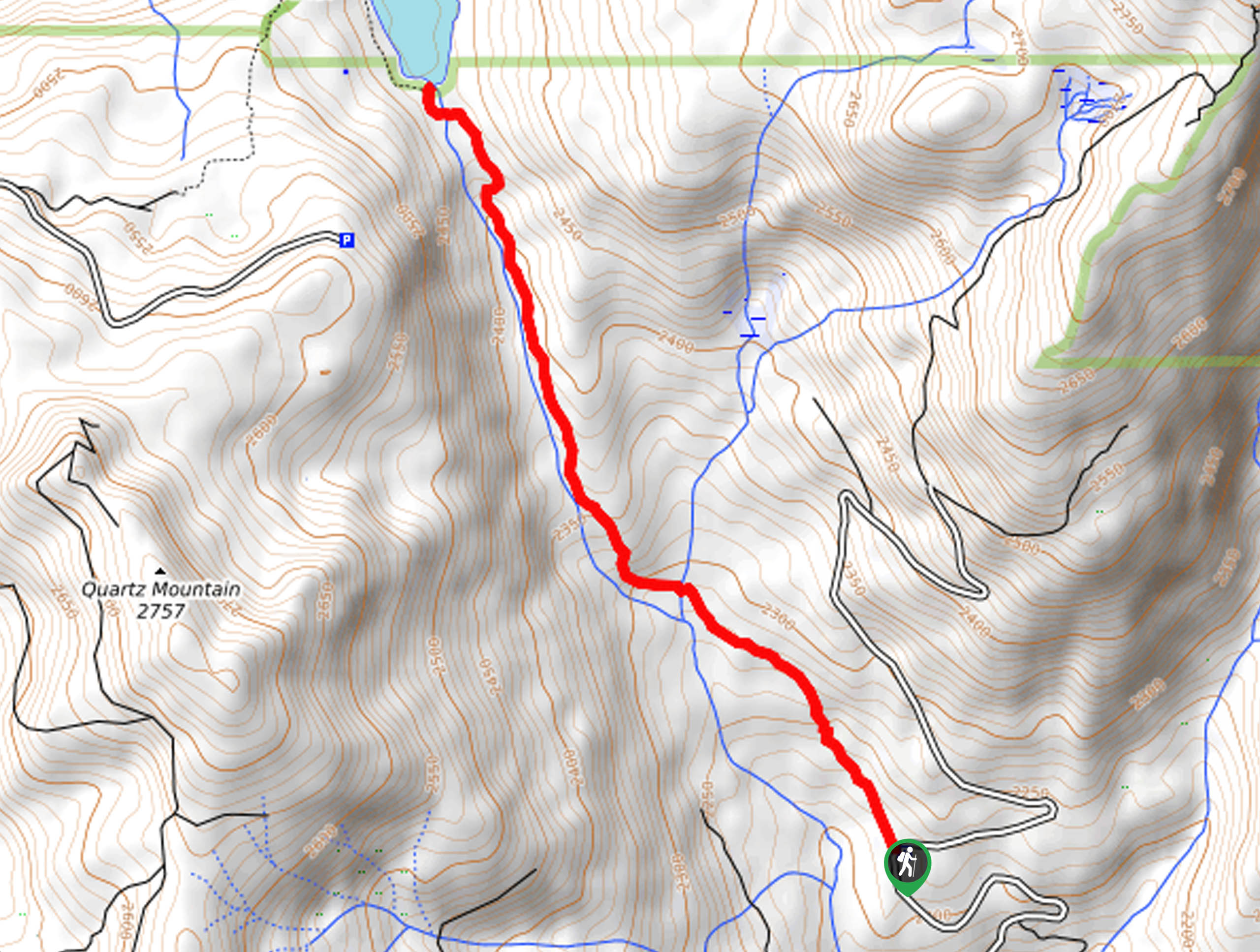
The Bald Mountain Trail departs from the trailhead off Dinkey Creek Road.

About
| Backcountry Campground | No |
| When to do | March-October |
| Pets allowed | Yes - On Leash |
| Family friendly | Older Children only |
| Route Signage | Poor |
| Crowd Levels | Moderate |
| Route Type | Out and back |
Bald Mountain Trail
Elevation Graph
Weather
Bald Mountain Trail Description
Immerse yourself in the High Sierra along the Bald Mountain Trail. This epic high-country adventure boasts unparalleled vistas of California’s mountainous wilderness. There are numerous approaches to access the peak, one of which is an off-roading route, meaning there will likely be an abundance of off-roaders at the summit also enjoying the view. Though the peak may be busy, the footpath is primitive and secluded before merging with the 4×4 route. Note the path is not well signposted, marked only with cairns—so we encourage the use of the trail GPS. Additionally, much of the terrain is covered in granite, which is extremely slippery when wet, so mind your footing!
Explore the diversity of the area’s flora and fauna as you venture the Bald Mountain Trail. One of the forest’s Botanical Areas, this local has an abundance of rare plants. From potentilla to cone-bearing trees, there is no shortage of unusual botanicals along this route. Enjoy the lush vegetation as you climb up and over granite outcrops through the forestlands before reaching the summit of Bald Mountain. Offering a diversity of scenery, this unassumingly beautiful route warrants countless photo opportunities, so be sure to charge up your camera! If time permits, we also suggest packing a picnic and having lunch overlooking the Sierra National Forest.
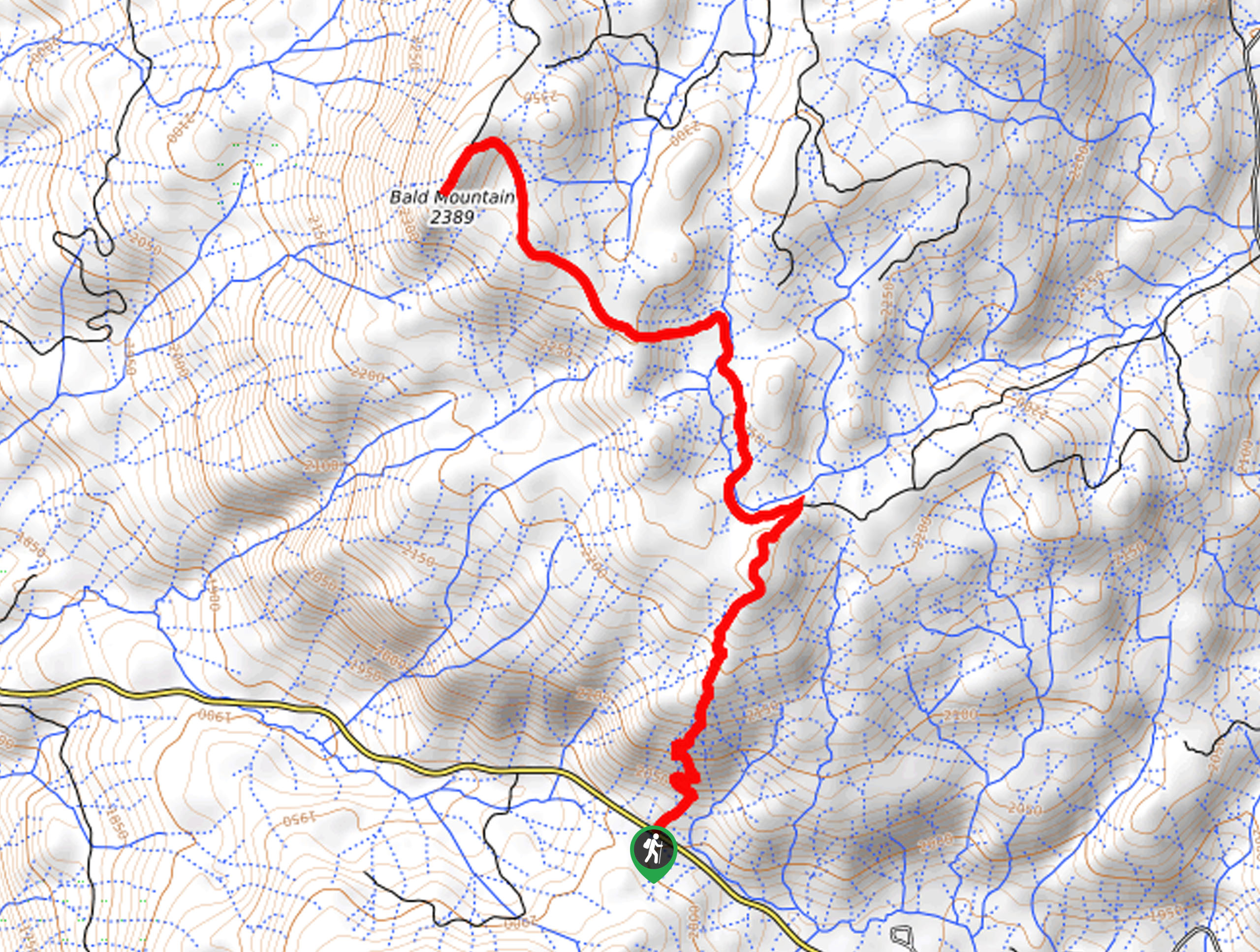
The Bald Mountain Hike departs from the parking lot off Dinkey Creek Road. From here, cross over the road, hiking along the route signposted as “trail.” Setting out from here, head northeast up the vertiginous terrain through mixed woodlands. This section of the route is the most intense, but don’t let that discourage you; it will soon plateau. Navigating several snowmelt streams, you will eventually reach an intersection. Veer left here, and the terrain will plateau. This segment of your hike shares the path will off-roading vehicles, so be mindful of passers-by.
Enjoy the shade of the towering pines while you can, as the closer you get to the summit, the shade will thin. Carefully maneuvering the increasing amount of granite rocks on the route, you will soon reach the peak of Bald Mountain. From atop the bare mountain top, you will be granted 360-degree vistas of the High Sierra. Explore the granite summit, and if you aren’t afraid of heights, head up to the fire tower! Above the clouds, the panoramas from the overlook will overwhelm you—marvel in the beauty of the mountainous landscape adorned with shimmering lakes and lush forestlands. After admiring the beauty of the scenery, retrace your footing back along the path to the trailhead.
Trail Highlights
Bald Mountain Fire Lookout Tower
The Bald Mountain Fire Lookout is an awesome overlook at the summit of Bald Mountain, often coined as the Island in the Sky. Construction of the tower commenced in 1950 and was finished in 1955. It wasn’t until 12 years later that there was an access road built up to the summit—which is now a popular off-roading route. This epic overlook is the piece de resistance—offering 1,000mi2 views of the encompassing High Sierra.
Insider Hints
Use the trail GPS as the path is not well signposted
Pack a picnic and have lunch overlooking the wilderness
Wear ankle bracing footwear as the terrain is rocky and uneven
Pack plenty of water, this vertiginous hike will tire you
Be mindful of wildlife as you trek!
Similar hikes to the Bald Mountain Trail hike
Post Corral Meadows Trail
A popular backpacking route turned epic day hike, the Post Corral Meadows Trail is an epic back-country expedition. Hike amongst…
Chiquito Pass Trail
The Chiquito Pass Trail is arguably one of the most scenic adventures in the Sierra National Forest. Wander up through…
Wuh-Ki'o Trail
The Wuh-Ki'o Trail is an unassumingly picturesque adventure in the Sierra National Forest. Traveling through meadowlands, brush, over bridges, and…
Comments