
Waters Gulch Loop Trail
View Photos
Waters Gulch Loop Trail
Difficulty Rating:
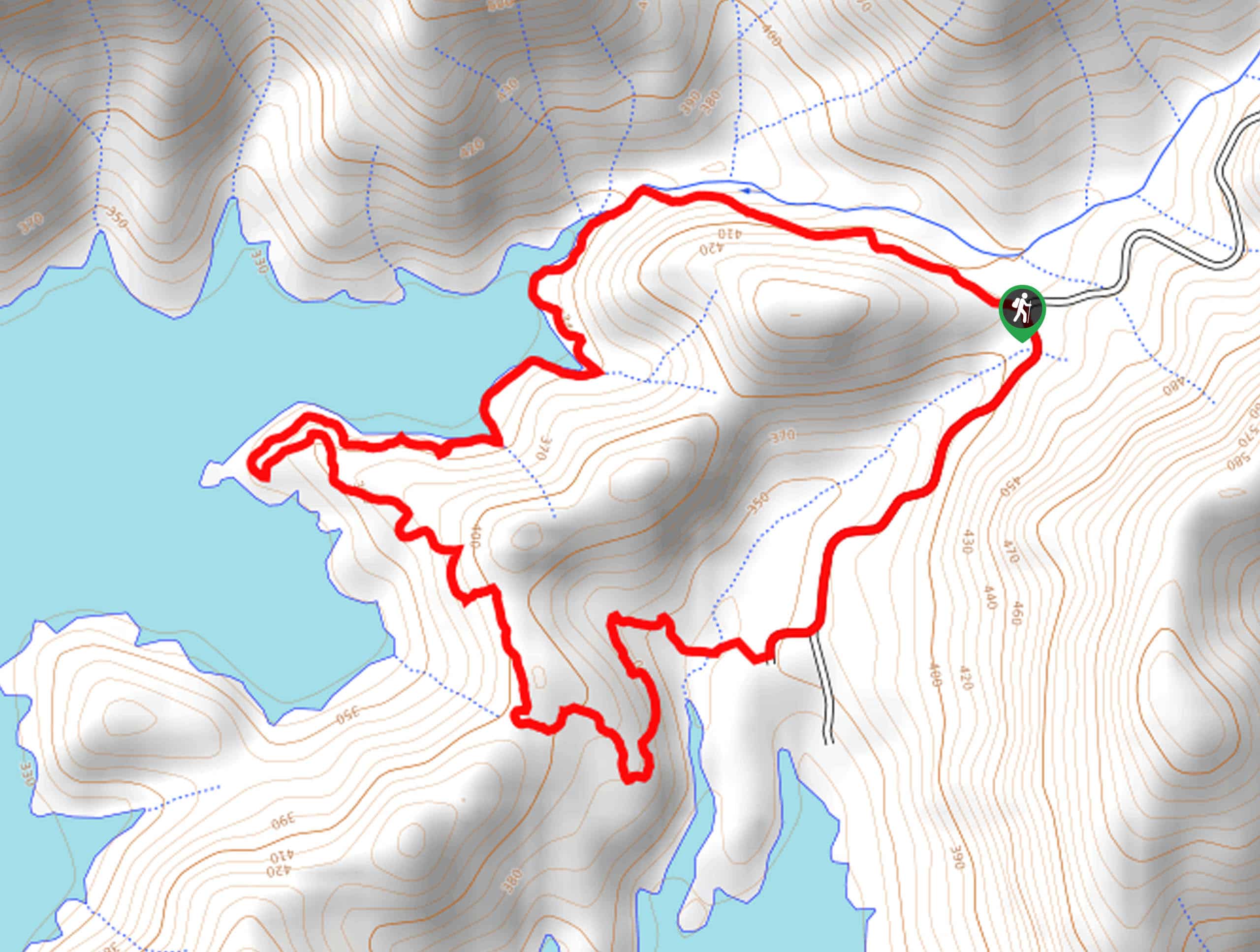
The Waters Gulch Loop Trail exhibits the beauty and diversity of Lake Shasta. Explore the shoreline of the largest man-made lake in California and revel in the contrast of the shimmering waters against the verdant foothills.
Getting there
The trailhead is located off Packers Bay Road.

About
| Backcountry Campground | No |
| When to do | Year-round |
| Pets allowed | No |
| Family friendly | Yes |
| Route Signage | Average |
| Crowd Levels | High |
| Route Type | Circuit |
Waters Gulch Loop Trail
Elevation Graph
Weather
Waters Gulch Loop Trail Description
This route makes for a wonderful day of hiking. This shared route attracts outdoor enthusiasts of all preferences, skill levels, and ages, so you will likely encounter traffic along the way. This epic excursion explores the mixed-coniferous forests, charming streams, and the impressive shoreline of the lake. Note part of this route wanders along the shoulder of a road, so be mindful of passers-by! Additionally, there is often blow-down along the trail, so you may have to take some creative detours—but the scenery is well worth it.
Setting out from the trailhead, this route can be completed in either direction, but we chose to venture counterclockwise. Heading west, you will gradually descend through the forestlands to the shoreline of a charming cove—marvel in the scene of the glittering water and intriguing layered banks that bound the waters. You will eventually reach a point that boasts an awesome overlook of the lake and surrounding foothills.
From here, the path will reroute hikers east, away from the lake, heading inland. When you ultimately reach Parkers Bay Road, turn left and meander along the shoulder of the road back to the trailhead.
Similar hikes to the Waters Gulch Loop Trail hike

East Weaver Lake Trail
The East Weaver Lake Trail is a wonderful adventure on the boundary of the Trinity Alps Wilderness that features amazing…
Elsa Rupp Nature Trail
The Elsa Rupp Nature Trail is a wonderful escape from the hustle and bustle of the city. Reconnect with nature…

Bluff Lake via PCT
The Bluff Lake via PCT is a secluded adventure in the Shasta-Trinity National Forest that offers wonderful scenery and makes…
Comments