
Mescal Mountain Loop Hike
View Photos
Mescal Mountain Loop Hike
Difficulty Rating:
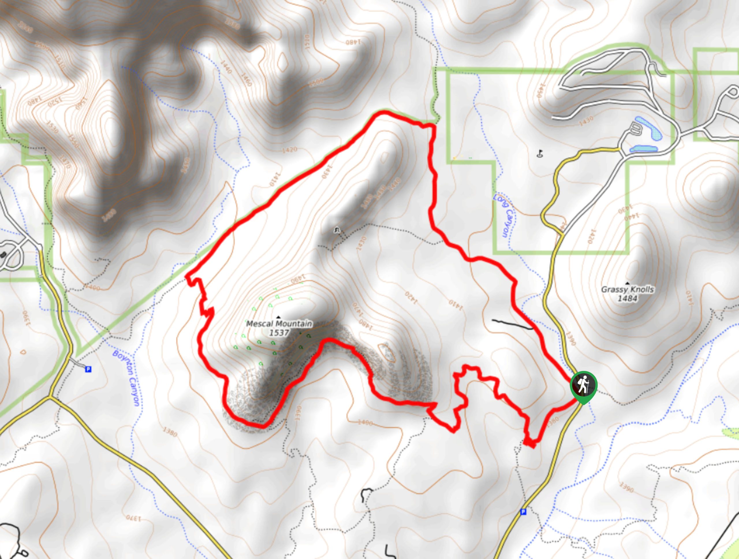
The Mescal Mountain Loop is a 4.4mi loop hike that uses Mescal Mountain Trail, Long Canyon Trail, and Deadman’s Pass Trail. With so many interconnecting trails in this area, we love making use of multiple routes to enjoy different vantage points. This route is rated as moderate and sees moderate traffic.
Getting there
The trailhead for the Mescal Mountain Loop is off Long Canyon Road.

About
| Backcountry Campground | No |
| When to do | Year-round |
| Pets allowed | Yes - On Leash |
| Family friendly | Yes |
| Route Signage | Average |
| Crowd Levels | Moderate |
| Route Type | Loop |
Mescal Mountain Loop Hike
Elevation Graph
Weather
Mescal Mountain Loop Hike Description
The Mescal Mountain Loop is an enjoyable hike suitable for all skill levels near Boynton Canyon and Long Canyon. The route is very scenic with both impressive canyons to admire as you hike. This trail can be extended using interconnecting routes if you want.
From the Long Canyon Trailhead, take Long Canyon Trail up along the east side of Mescal Mountain. Where the route splits, stay left onto Deadman’s Pass Trail. This section of the hike takes you between Mescal Mountain and the hills that lead up to the canyons. It’s a straight shot to the point where Mescal Mountain Trail splits off to the left. Go left here, wrapping closely around the southern base of Mescal Mountain.
Stay left at the two junctions on this section of the route. This will take you back to the Long Canyon Trailhead, where you can head off to whichever adventure is next.
Similar hikes to the Mescal Mountain Loop Hike hike

Margs Draw Trail
Margs Draw Trail is a bit of a hidden gem. This trail doesn’t get as much traffic as other nearby…

Baby Bell, Llama, and Bail Loop
The Baby Bell, Llama, and Bail Loop is a 3.6mi hike in Sedona near Bell Rock and Courthouse…

Herkenham Trail
Herkenham Trail is a 2.0mi out and back trail in the Coconino National Forest near Sedona. This route…
Comments