
Flaming Geyser State Park Loop
View Photos
Flaming Geyser State Park Loop
Difficulty Rating:
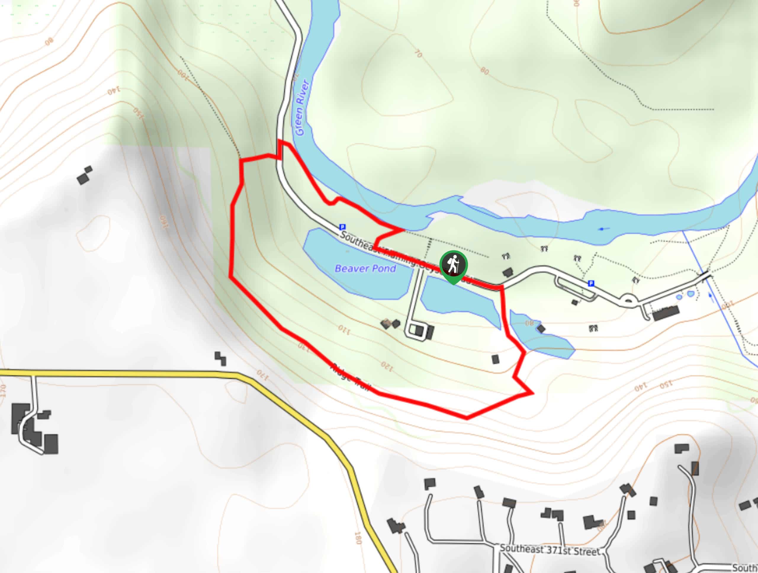
Flaming Geyser State Park Loop is a 1.0mi easy nature walk in the park that is suitable for all skill levels. This brief walk passes through the lush forest on one side and the river and ponds on the other. It’s a good choice for families with small children and those wanting a quick outing. This trail can sometimes become busy, so try to arrive early on weekends. You could easily start with this loop and then spend the entire day exploring the park, including the geysers. Bring a picnic lunch to enjoy on one of the many benches along the path.
Note that the geyser is not on this trail, but it’s just a short walk from the east side of the loop. Additionally, this path can be a bit overgrown in spots.
Getting there
The trailhead for the Flaming Geyser State Park Loop is along SE Flaming Geyser Road. There are several parking options along this road.

About
| Backcountry Campground | No |
| When to do | Year-round |
| Pets allowed | Yes - On Leash |
| Family friendly | Yes |
| Route Signage | Average |
| Crowd Levels | High |
| Route Type | Loop |
Flaming Geyser State Park Loop
Elevation Graph
Weather
Flaming Geyser State Park Loop Description
Flaming Geyser State Park is a great place to spend the day exploring with family, and this quick loop walk is a perfect start or end to your day. The trail is less than 2km long and requires very little elevation gain, making it a good choice for families with young children.
There are a few benches along the trail that make for good picnic spots. Note that some of the trail is overgrown, but it’s nothing too difficult to get through.
Begin from the trailhead off SE Flaming Geyser Road just west of the restrooms. You can hike this loop either way, but we’ll describe it clockwise.
Go to your left and cross the road, passing the info kiosk and passing between two ponds on the Ridge Trail. You’ll go up two brief zig-zagging turns that gain a very manageable amount of elevation and then head to your right through the trees.
Traverse through the forest, enjoying the trees and the wildlife you might be able to spot. Take a rest on some of the benches or see if you can ID the trees.
The trail eventually begins to descend gradually. You’ll reach an intersection with a spur trail where you’ll go right. This will take you across the road and alongside the Green River back to the trailhead.
Note that the former flaming geyser is not within this loop. To see the site of the geyser, walk east past the restrooms and past the building on your right. The geyser is on your right past this building.
Trail Highlights
Flaming Geyser State Park
Flaming Geyser State Park is a 503-acre area on the Green River known for a flame that burned through a basin. The flame was a result of a methane gas pocket 1000ft below ground. Today, the park offers hiking trails, salmon ponds, picnic areas, and (of course) geysers. It’s a wonderful place to spend an afternoon hiking, kayaking, watching the geysers, or just relaxing.
Frequently Asked Questions
Do I need a pass for Flaming Geyser State Park?
You’ll need a Discover Pass to visit the park.
Can you swim at Flaming Geyser State Park?
Yes, you can swim in the river at the park.
Insider Hints
Check out Bubbling Geyser for an active geyser experience.
Watch for model airplanes being flown by hobbyists in the park.
Similar hikes to the Flaming Geyser State Park Loop hike

Sky Country to Harvey Manning Loop
The Sky Country to Harvey Manning Loop is a 4.2mi loop trail in the northern part of Cougar…

Iverson Spit Preserve Loop
The Iverson Spit Preserve Loop is a 1.2mi loop hike right on the beach, coursing through a beaver…

Lowell Riverfront Trail
The Lowell Riverfront Trail is a 3.0mi route alongside the Snohomish River in Everett. This trail is heavily…
Comments