
First Fork Trail
View Photos
First Fork Trail
Difficulty Rating:
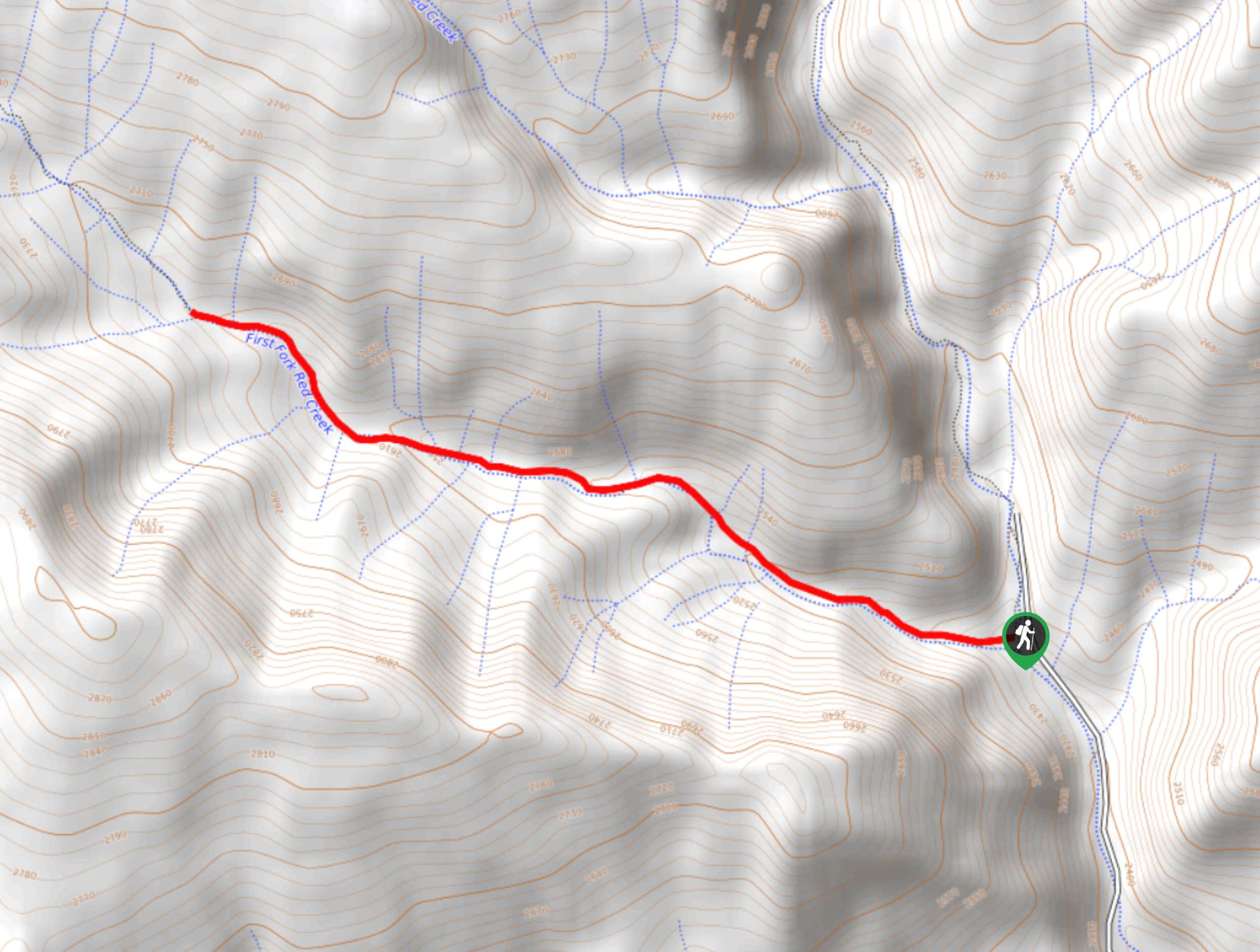
The First Fork Trail is a fantastic adventure in the San Juan Mountains of Colorado that will take you through the forest to reconnect with the beauty of nature. While out hiking the trail, you will follow along the winding banks of First Fork Red Creek and relax in the tranquil forest setting filled with beautiful aspens. Remember to bring bear spray and make plenty of noise along the trail.
Getting there
The starting point for the First Fork Trail can be found along County Road 246, just 1.8mi north of the junction with County Road 240.

About
| Backcountry Campground | No |
| When to do | March-October |
| Pets allowed | Yes |
| Family friendly | Yes |
| Route Signage | Average |
| Crowd Levels | Low |
| Route Type | Out and back |
First Fork Trail
Elevation Graph
Weather
First Fork Trail Description
If you are after a bit of solitude on the trail and want to take some time to reconnect with nature, then the lightly-trafficked paths of the First Fork Trail will be a great option for you to explore the natural beauty of the San Juan Mountains.
Setting out from the trailhead, you will head to the northwest and follow a route that runs parallel to the First Fork Red Creek. As you gain a small amount of elevation through the forest landscape, take some time to appreciate the beauty of the aspen groves and the rushing waters of the creek, before eventually arriving at the endpoint of the route. From here, you can simply turn back along the same trail and follow it back into the trailhead where you began your laidback woodland adventure.
Similar hikes to the First Fork Trail hike

Twin Buttes and Lightner Creek Loop Trail
The Twin Buttes and Lightner Creek Loop Trail is a great hiking route in Durango, Colorado that features some challenging…

Meadow Loop via Horse Gulch Trail
The Meadow Loop via Horse Gulch Trail is a great hiking route in Durango that will take you uphill for…

The Ridge Trail
The Ridge Trail - also known as Raiders Ridge Trail - is an amazing hiking route in Durango, Colorado that…
Comments