
Lion Peak Trail
View Photos
Lion Peak Trail
Difficulty Rating:
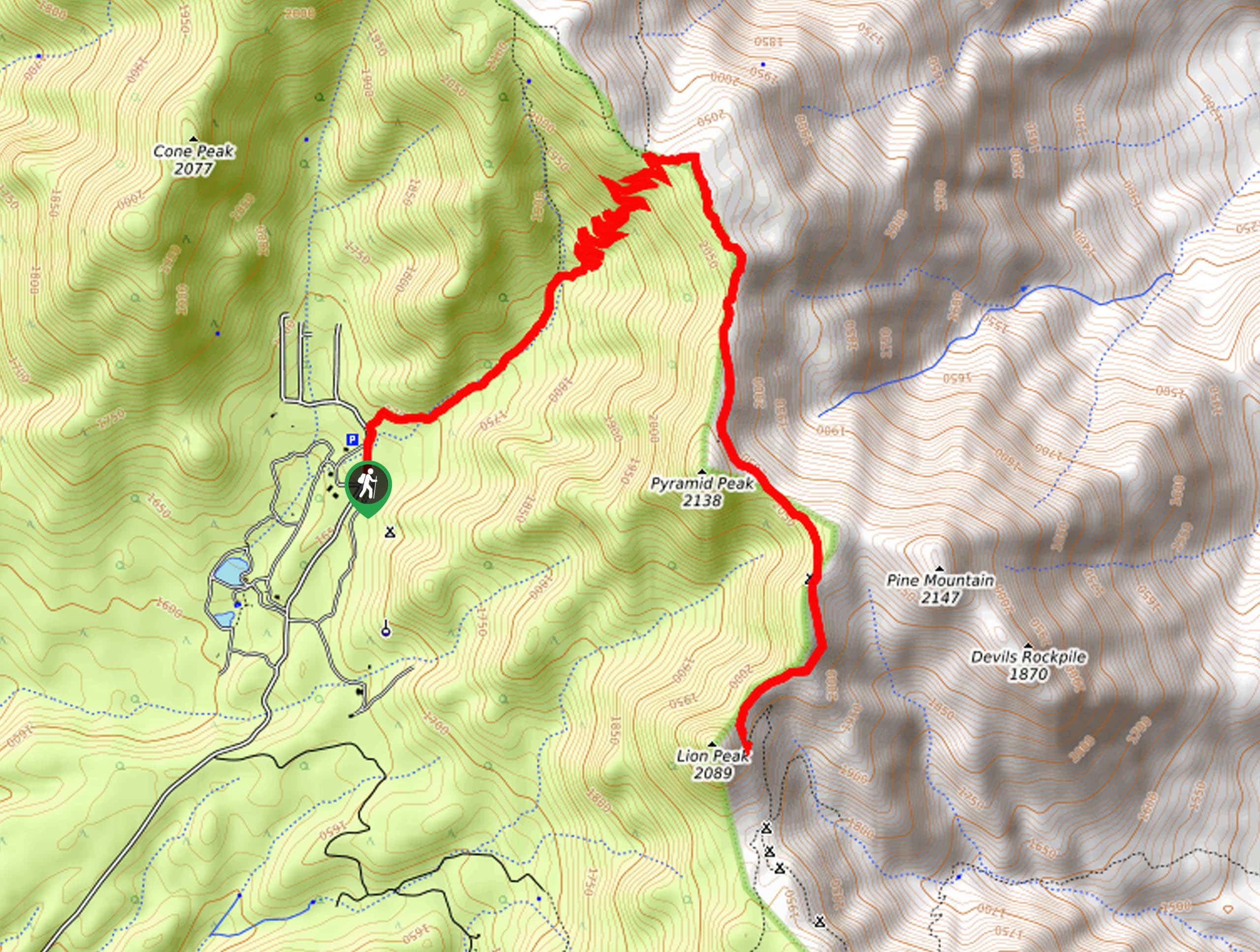
The Lion Peak Trail is a fantastic adventure in the San Bernardino National Forest that will lead you along a winding trail up the mountainside for gorgeous Southern California Views. While out hiking the trail, you will climb uphill through a series of switchbacks to reach the Pacific Crest Trail, which you will follow south on the climb to the summit of Lion Peak. Hikers should take note that the terrain along this route is quite rugged and rocky, so make sure to wear proper hiking boots with good ankle support and bring hiking poles for stability.
Getting there
The access point for the Lion Peak Trail can be found next to Camp Scherman along Morris Ranch Road, just northwest of Thomas Mountain.

About
| Backcountry Campground | Camp Scherman |
| When to do | Year-Round |
| Pets allowed | Yes |
| Family friendly | Older Children only |
| Route Signage | Average |
| Crowd Levels | Low |
| Route Type | Out and back |
Lion Peak Trail
Elevation Graph
Weather
Lion Peak Trail Description
While the Lion Peak Trail does feature some rugged terrain, the grade of the climb is actually quite mild, making this an exceptional hiking route if you are wanting to experience some jaw-dropping Southern California Views.
Setting out from the trailhead, you will make your way to the northeast alongside the banks of the East Canyon Creek, eventually breaking off to the right where the terrain becomes a bit more steep. Here, you will need to traverse a series of switchbacks along the route in order to meet up with the Pacific Crest Trail at an elevated position.
Turning right onto the PCT, you will follow it to the southeast along an undulating ridge line that will bring you up to the summit of Lion Peak. Once there you will enjoy some incredible views of the surrounding landscape, including the Santa Rosa Range to the south, Coachella Valley to the east, and the San Jacinto Wilderness Area to the north. Once you have taken in the views, follow the Lion Peak Trail back down the way that you came to return to the trailhead.
Similar hikes to the Lion Peak Trail hike

Bluff Mesa Hike
The Bluff Mesa Hike is a fantastic adventure in Southern California that features a lovely woodland setting and can be…

Palm View Peak Trail
The Palm View Peak Trail is a great hiking route in the San Bernardino National Forest that features a solid…

Cram Peak Ridge Trail
The Cram Peak Ridge Trail is a fantastic, albeit difficult, hiking route in the San Bernardino National Forest that will…
Comments