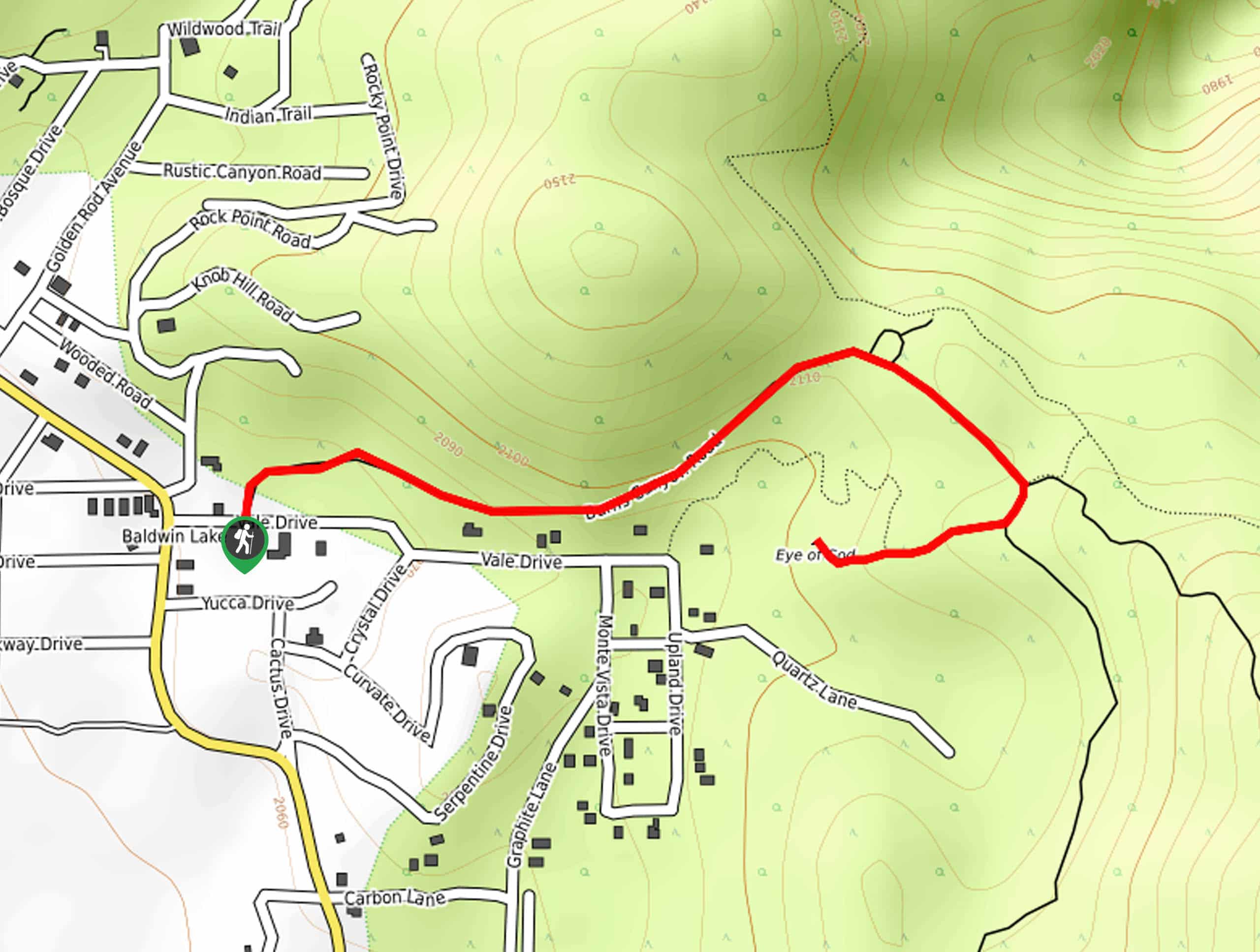
Eye of God Trail
View Photos
Eye of God Trail
Difficulty Rating:
The Eye of God Trail is a great little hiking route near Big Bear Lake, California that will lead you along a rocky road to reach a fascinating geological feature. Once consisting of a giant whit quartz megalith, the Eye of God was a sacred site to the Native American Serrano people before it was destroyed by miners in search of gold. Hikers should take note that this trail follows along a rocky and rugged road, so be sure to wear proper hiking footwear.
Getting there
The trailhead for the Eye of God Trail can be found along Vale Drive, just east of the junction with Baldwin Lake Road.

About
| Backcountry Campground | No |
| When to do | April-October |
| Pets allowed | Yes - On Leash |
| Family friendly | Yes |
| Route Signage | Average |
| Crowd Levels | Moderate |
| Route Type | Out and back |
Eye of God Trail
Elevation Graph
Weather
Eye of God Trail Description
Combining the beauty of nature, interesting geological/historical features, and a short overall distance, the Eye of God Trail is an excellent hiking route if you are simply looking to get out onto the trails for a quick jaunt outdoors.
Setting out from the trailhead, you will follow Burns Canyon Road as it bends to the east and climbs slightly uphill through the desert. Keep an eye on your footing here, as the road can be quite rocky and rugged in places.
Eventually, the trail will bend back to the west and bring you to the edge of some trees, where you will be able to spot what is left of the Eye of God. After exploring the area and investigating this once-magnificent rock formation, you can simply head back along the same route to return to the trailhead.
Similar hikes to the Eye of God Trail hike

Bluff Mesa Hike
The Bluff Mesa Hike is a fantastic adventure in Southern California that features a lovely woodland setting and can be…

Palm View Peak Trail
The Palm View Peak Trail is a great hiking route in the San Bernardino National Forest that features a solid…

Cram Peak Ridge Trail
The Cram Peak Ridge Trail is a fantastic, albeit difficult, hiking route in the San Bernardino National Forest that will…
Comments