
Bertha Peak Trail
View Photos
Bertha Peak Trail
Difficulty Rating:
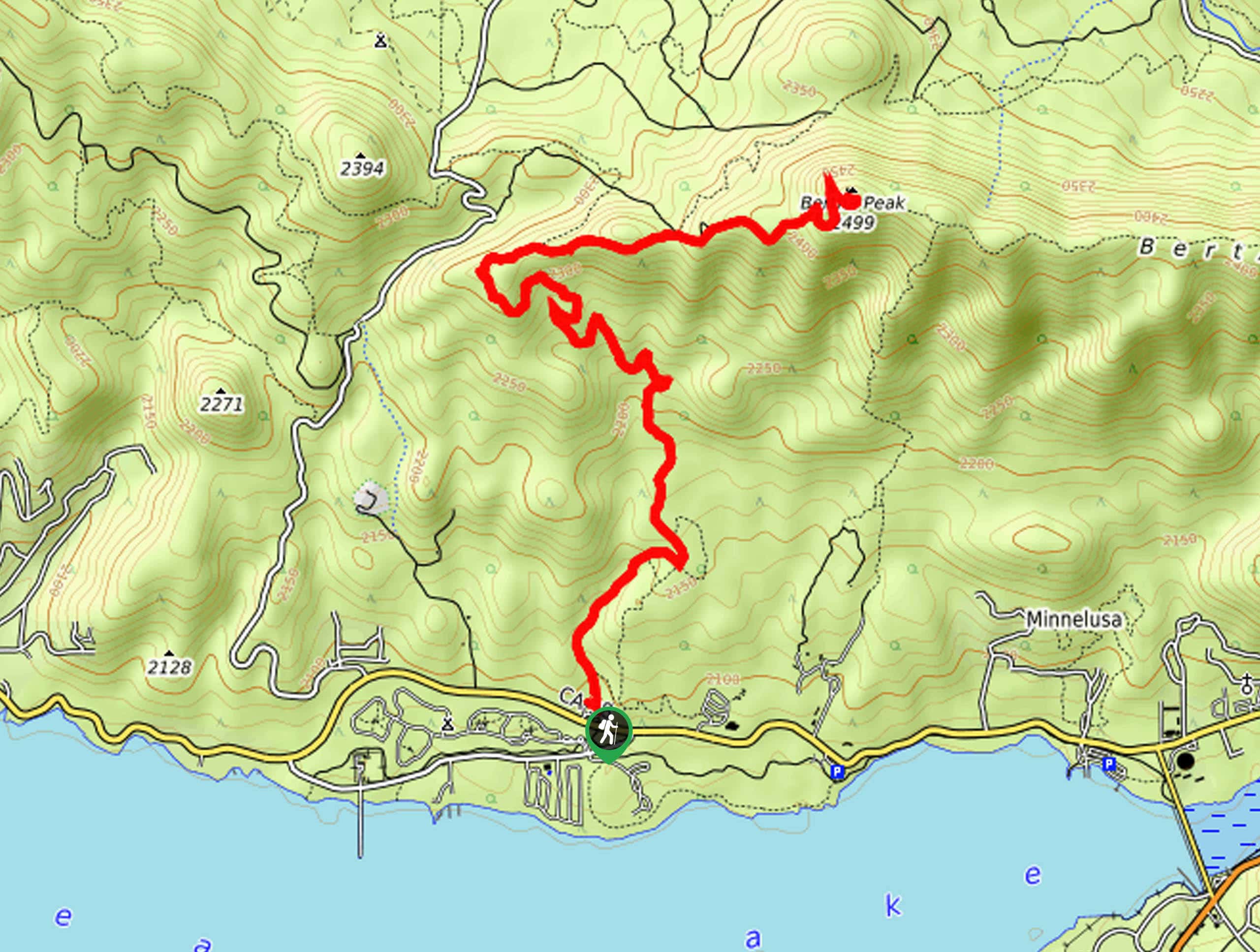
The Bertha Peak Trail is a wonderfully scenic hiking route in the San Bernardino National Forest that will see you climb uphill for sweeping landscape views. While out on the trail, you will climb up the Cougar Crest Trail through the forest, before pushing up to the summit of Bertha Peak for a fantastic sightline over Big Bear Lake. While the trail isn’t overly difficult, there are some rugged sections with rocky terrain, so make sure to take your time and watch your footing.
Getting there
The starting point for the Bertha Peak Trail can be found along CA-38 at the Cougar Crest Trailhead.

About
| Backcountry Campground | Serrano Campground |
| When to do | March-September |
| Pets allowed | Yes |
| Family friendly | Older Children only |
| Route Signage | Average |
| Crowd Levels | High |
| Route Type | Out and back |
Bertha Peak Trail
Elevation Graph
Weather
Bertha Peak Trail Description
Featuring woodland terrain and beautifully scenic views of the surrounding California landscape, the Bertha Peak Trail is a fun adventure, although there are some fairly rugged stretches of trail with loose rock. Make sure that you wear proper hiking boots for this adventure and bring plenty of water. This is also a popular trail, so you will want to arrive early in order to secure a parking space and make sure to have your Adventure Pass visible in your vehicle.
If you are after a great adventure in San Bernardino National Forest that features the perfect balance between challenge and reward, then the Bertha Peak Trail will be a great route for you to explore. Along the trail you will work your way uphill through a beautiful forest landscape and stop off at several scenic viewpoints, before making the final push onto the summit.
Setting out from the parking area next to the Cougar Crest Trailhead, you will make your way to its northeast end in order to pick up the trail. Take a moment to look over the information board for the route, before heading north through the tree cover.
Keeping left along the trail, you will climb uphill through the forest for the next 2.4mi, passing through some peaceful stretches of woodland terrain as you traverse the undulating landscape. This portion of the route also features several scenic lookouts over Big Bear Lake, so be sure to pause and take in the views.
Reaching a fork in the trail, you will take the path on the right and follow it uphill along the ridge for the next 0.4mi. Here, you will meet up with the edge of Bertha Peak Road and follow it to the right on the way to the summit.
After a relatively short 0.7mi walk along the road, you will arrive at the summit of Bertha Peak and be met with gorgeous views overlooking Big Bear Lake to the south and the surrounding mountains in every direction. Take some time here to rest up and take in the beautiful views, before heading back down along the same trail for the return to the starting point of the Bertha Peak Trail.
Trail Highlights
Big Bear Lake
Big Bear Lake can be found in the San Bernardino Mountains and has a surface area of 2971 acres, making it Southern California’s largest recreational lake. While the lake has no rivers feeding into it, it is seasonally replenished by the melting snow from the nearby mountain peaks.
Frequently Asked Questions
How high is Bertha Peak?
The summit of Bertha Peak is situated 8201ft above sea level.
Are there toilet facilities along the Bertha Peak Trail?
While there are no toilet facilities along the Bertha Peak Trail, there are some at the trailhead.
Insider Hints
There are some rugged stretches of trail along this route, so make sure to wear sturdy hiking boots.
You will need to purchase an Adventure Pass for this hike.
Arrive early to secure parking.
Toilet facilities can be found near the trailhead.
Similar hikes to the Bertha Peak Trail hike

Bluff Mesa Hike
The Bluff Mesa Hike is a fantastic adventure in Southern California that features a lovely woodland setting and can be…

Palm View Peak Trail
The Palm View Peak Trail is a great hiking route in the San Bernardino National Forest that features a solid…

Cram Peak Ridge Trail
The Cram Peak Ridge Trail is a fantastic, albeit difficult, hiking route in the San Bernardino National Forest that will…
Comments