
Willow Lake Trail
View Photos
Willow Lake Trail
Difficulty Rating:
The Willow Lake Trail is a family-friendly hiking route in the beautiful Uinta-Wasatch-Cache National Forest east of Salt Lake City. This is a highly popular route that is a favorite hiking and snowshoeing trail by area locals. On your way to Willow Lake, keep an eye out for forest wildlife, such as moose and deer that frequent this trail.
Getting there
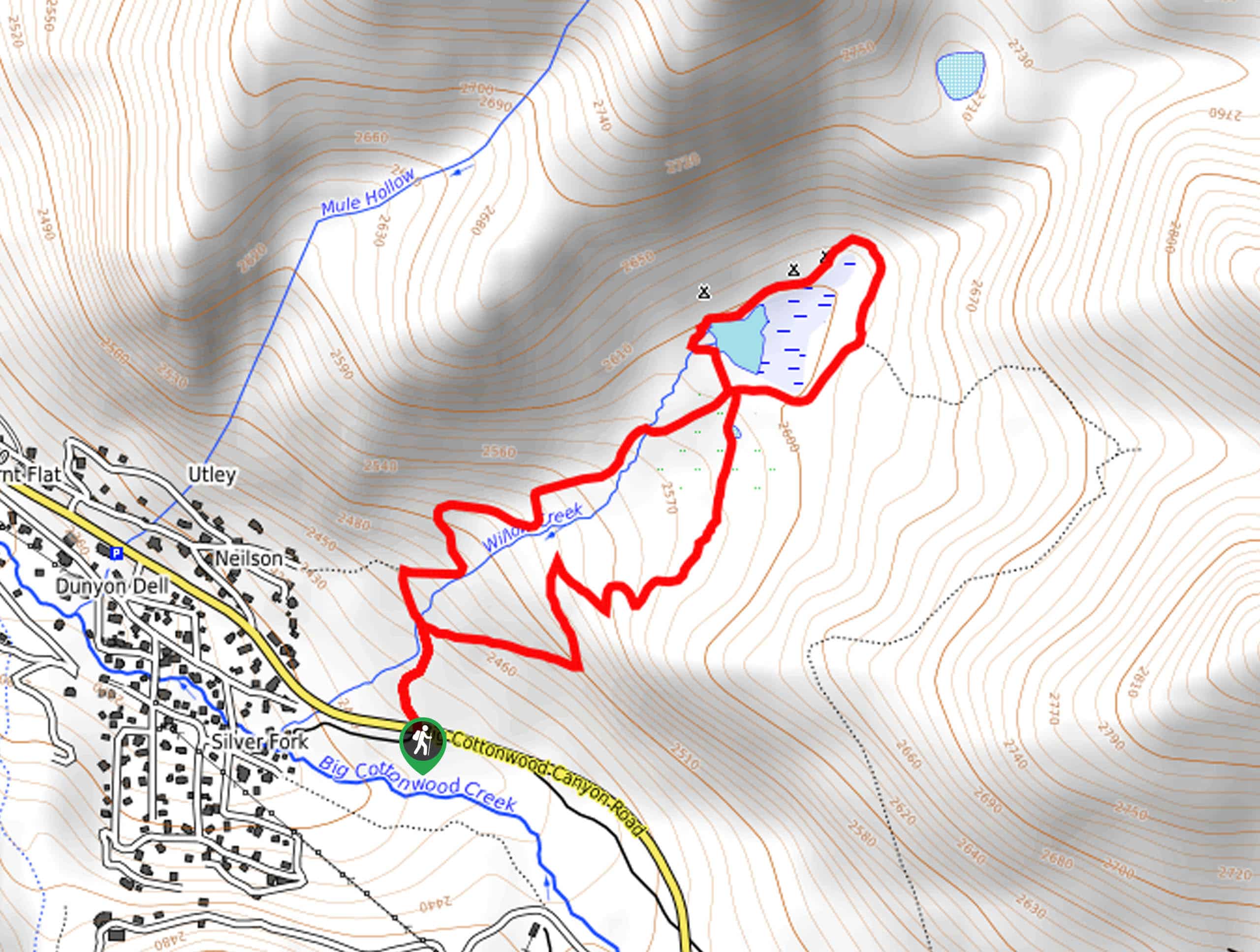
This hike begins at the trailhead across from the highway 190 turn off onto Silver Fork Road.

About
| Backcountry Campground | Yes |
| When to do | year-round |
| Pets allowed | No |
| Family friendly | Yes |
| Route Signage | Average |
| Crowd Levels | High |
| Route Type | Lollipop |
Willow Lake Trail
Elevation Graph
Weather
Willow Lake Trail Description
The Willow Lake hiking trail is one of the most popular routes in the Uinta-Wasatch-Cache National Forest. This trail, unfortunately, is not dog-friendly as it is part of the Big Cottonwood Canyon watershed. The hike up to Willow Lake does get quite icy and slushy in the spring and fall, if you are heading out at that time of year, we recommend bringing along traction devices such as microspikes to aid your journey.
This beautiful, short hike to Willow lake is popular for a reason. This trail is absolutely stunning especially in the fall when the autumn colors light up the forest in shades of yellow and gold. In the winter, this route makes an excellent snowshoeing trail with soft, deep powder, and the hush of gently falling snow blanketing the Uinta forest.
To hike up to Willow Lake, begin at the trailhead on the north side of highway 190/Big Cottonwood Canyon Road. From the trailhead, head north for 0.1mi to a divide. This divide marks the start of the loop. Take a right at the divide and head northeast for 0.8mi up to Willow Lake.
Once you reach Willow Lake, follow the path as it loops around the shoreline. Once you’ve completed the loop, follow the trail to your right to cross over Willow Creek and head back southwest. Take a left at the first divide, cross over the creek once again and you will find yourself back at the beginning of the loop. From here, follow the familiar path back to the trailhead.
Frequently Asked Questions
Can you swim in Willow Lake, Utah?
No, swimming is not permitted in Willow Lake.
Insider Hints
Don’t forget the camera—this trail is gorgeous.
This route starts out steep but keep going—it gets easier.
Keep an eye out for moose, they are often seen grazing near the lake. If you do see wildlife, do not feed or approach them, admire them from a safe distance.
Similar hikes to the Willow Lake Trail hike

Willow Hollow, Ridge, and Pine Hollow Trail
The Willow Hollow and Pine Hollow Trail is a beautiful route in the Uinta-Wasatch-Cache National Forest. This trail is an…

Solitude to Beaver Pond Trail
The Solitude to Beaver Ponds Trail is a beautiful hike through the Uinta-Wasatch-Cache National Forest. This trail is lush and…

City Creek Canyon Road
The City Creek Canyon Road is a popular trail just north of downtown Salt Lake City, Utah. This path is…
Comments