
Waterfall Canyon Trail via Ogden Park
View Photos
Waterfall Canyon Trail via Ogden Park
Difficulty Rating:
The Waterfall Canyon Trail via Ogden Park is a gorgeous route east of Salt Lake City, Utah. This moderately challenging hike follows a rocky trail to a beautiful cascading waterfall. For the best views on this hike, head out in spring when the waterfall is flowing in full force.
Getting there
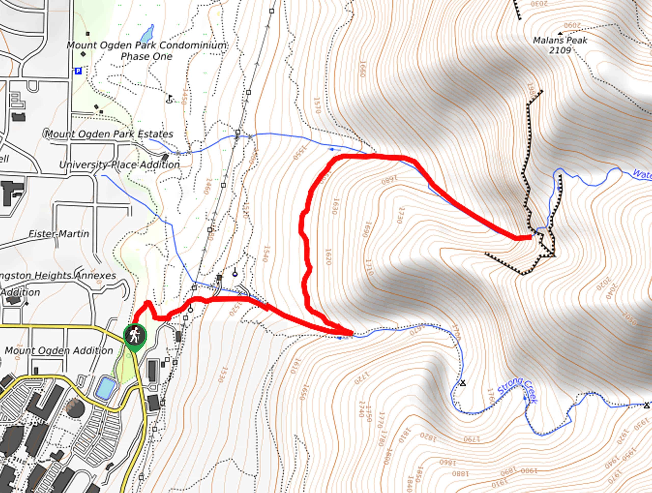
This hike begins at the 36th Street Trailhead in South Ogden.

About
| Backcountry Campground | No |
| When to do | March to October |
| Pets allowed | Yes - On Leash |
| Family friendly | Older Children only |
| Route Signage | Average |
| Crowd Levels | High |
| Route Type | Out and back |
Waterfall Canyon Trail via Ogden Park
Elevation Graph
Weather
Waterfall Canyon Trail via Ogden Park Description
The Waterfall Canyon Trail via Ogden Park is a beautiful hike in the Uinta-Wasatch National Forest. This trail is appropriate for moderately experienced hikers and families with older children. Although this hike isn’t especially long, it does follow a rocky trail with some steep inclines. Proper hiking footwear and lots of water is necessary for this hike. If you are hiking this route in the winter, be sure to bring along a pair of traction devices such as microspikes as this trail does get icy.
The last thing you’ll need to bring on this trail is a camera; although this trail is most popular in the summer, the Waterfall Canyon Trail is absolutely gorgeous year-round. If you are visiting Salt Lake City from out of town, or just a local looking to get out and do some exploring, the Waterfall Canyon Trail via Ogden Park should be high on your to-do list.
To hike Waterfall Canyon via Ogden Park, begin at the 36th street Trailhead in South Ogden. From the trailhead, follow Gibs Loop northeast for 0.3mi to Strong Creek. At the creek, follow the Strong Canyon Trail east for a third of a mile then take a sharp left onto the Bonneville Shoreline Trail. Head north along the Bonneville Shoreline trail to Waterfall Creek, cross over the creek then follow the Waterfall Canyon Trail 0.4mi to the falls themselves.
Take a long rest at the falls and enjoy the refreshing mist on your face before turning around and following your footsteps back out to the trailhead.
Frequently Asked Questions
How long is the Waterfall Canyon Trail?
The Waterfall Canyon Trail via Ogden Park is 3.3mi round-trip
Are dogs allowed on the Waterfall Canyon Trail?
Yes, dogs are allowed on the Waterfall Canyon Trail via Ogden Park but must be kept on-leash for the duration of their hike.
Insider Hints
This trail gets very icy in the winter, be sure to bring along traction devices if you are hiking at that time of year.
This trail is very popular, head out early in the morning to beat the crowds.
For a variation on this hike, check out the Waterfall Canyon Trail.
Similar hikes to the Waterfall Canyon Trail via Ogden Park hike

Willow Hollow, Ridge, and Pine Hollow Trail
The Willow Hollow and Pine Hollow Trail is a beautiful route in the Uinta-Wasatch-Cache National Forest. This trail is an…

Solitude to Beaver Pond Trail
The Solitude to Beaver Ponds Trail is a beautiful hike through the Uinta-Wasatch-Cache National Forest. This trail is lush and…

City Creek Canyon Road
The City Creek Canyon Road is a popular trail just north of downtown Salt Lake City, Utah. This path is…
Comments