The Mineral Fork Trail
View Photos
The Mineral Fork Trail
Difficulty Rating:
The Mineral Fork Trail is a beautiful and challenging hike in the Uinta-Wasatch-Cache National Forest, east of Salt Lake City. In the summer, this route is popular with hikers, bikers, runners, and OHV drivers. In winter, this is a beautiful trail for winter hiking and snowshoeing.
Getting there
The Mineral Fork Trail begins on the south side of highway 190/Big Cottonwood Canyon Road, 1.5mi east of the Mill B South Trailhead.

About
| Backcountry Campground | No |
| When to do | Year-round |
| Pets allowed | No |
| Family friendly | No |
| Route Signage | Average |
| Crowd Levels | Moderate |
| Route Type | Out and back |
The Mineral Fork Trail
Elevation Graph
Weather
The Mineral Fork Trail Description
The Mineral Fork Trail is a great challenge for experienced hikers. This route is steep and rocky. Large rocks on top of a gravel base can make sections of this trail treacherous so be mindful of your feet and take your time, especially on the descent. Proper hiking footwear is essential for this trail and we recommend bringing along a set of hiking poles as well. The Mineral Fork Trail is a great route to see wildlife, such as deer, coyotes, and bobcats. For a special experience, head out on this trail early in the morning to catch the sunrise over the Utah landscape.
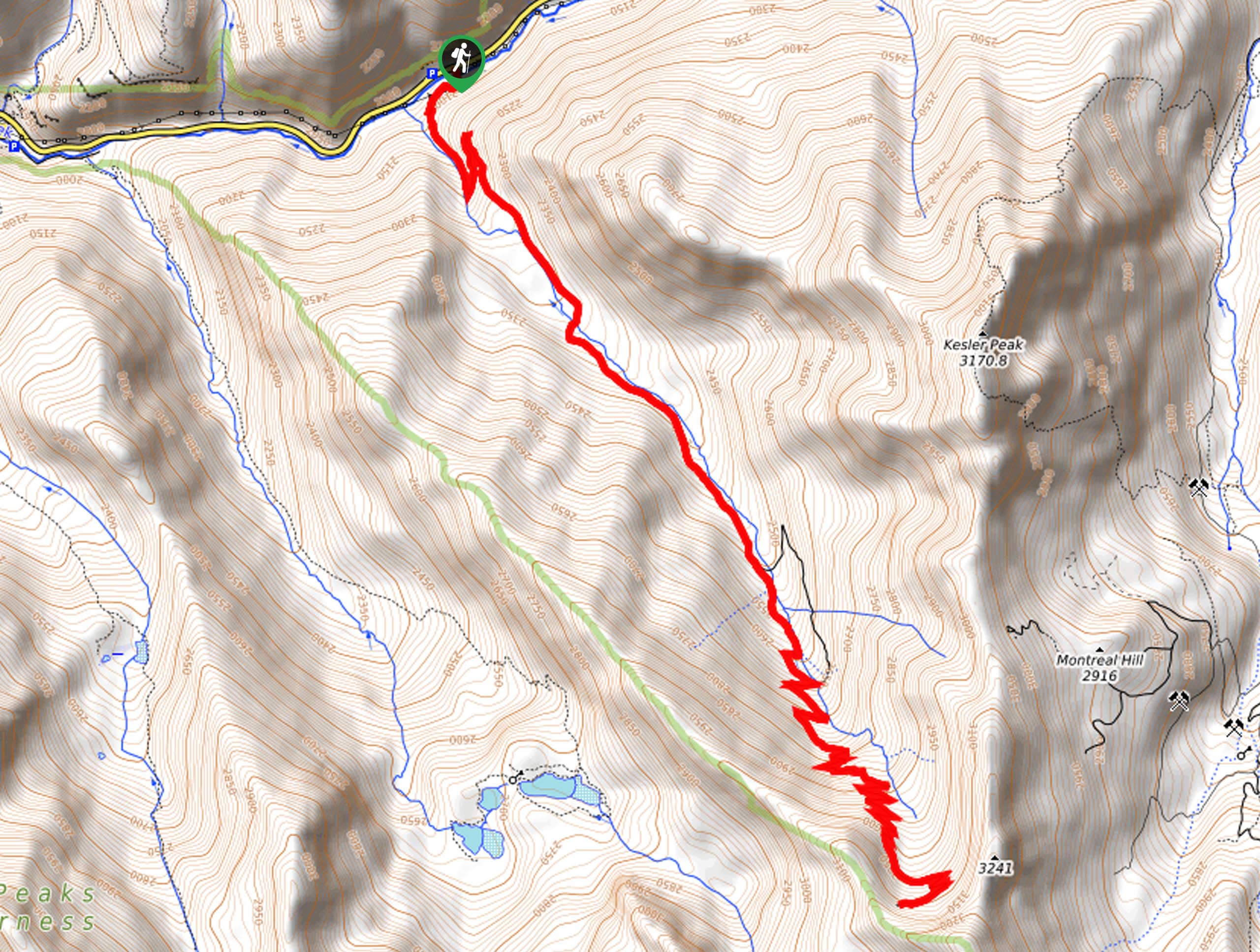
From the trailhead, follow the path southeast along Mineral Fork. Stay right at the two divides, then climb the switchbacks to the viewpoint at the old Regulator Johnson Mine.
Take a well deserved rest and admire the gorgeous views of the valley below before turning around and following the same route back to the trailhead. Be sure to exercise caution on the way back down, the rocks and gravel can make for some slippery sections, take your time and arrive back at the trailhead safely.
Similar hikes to the The Mineral Fork Trail hike

Willow Hollow, Ridge, and Pine Hollow Trail
The Willow Hollow and Pine Hollow Trail is a beautiful route in the Uinta-Wasatch-Cache National Forest. This trail is an…

Solitude to Beaver Pond Trail
The Solitude to Beaver Ponds Trail is a beautiful hike through the Uinta-Wasatch-Cache National Forest. This trail is lush and…

City Creek Canyon Road
The City Creek Canyon Road is a popular trail just north of downtown Salt Lake City, Utah. This path is…
Comments