
Mill Creek Horse Trail
View Photos
Mill Creek Horse Trail
Difficulty Rating:
Indulge yourself in the magical scenery of California’s coastal rainforests along the Mill Creek Horse Trail. This secluded adventure provides the perfect opportunity for self-reflection as you disconnect from the real world and venture deep into the wilderness.
Getting there
Find the trailhead and parking lot off Bertsch Street.

About
| Backcountry Campground | No |
| When to do | Year-round |
| Pets allowed | No |
| Family friendly | Older Children only |
| Route Signage | Average |
| Crowd Levels | Low |
| Route Type | Lollipop |
Mill Creek Horse Trail
Elevation Graph
Weather
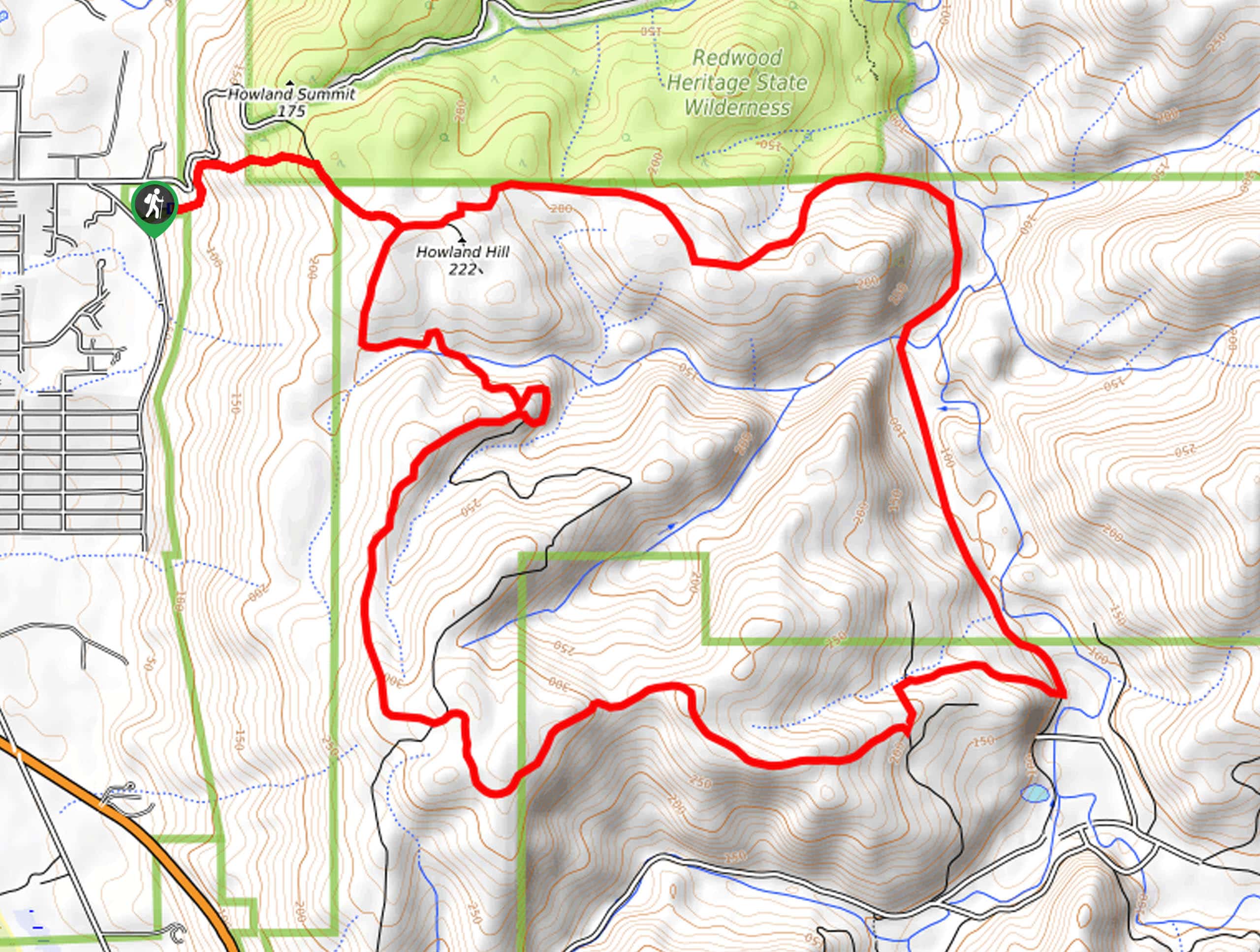
Mill Creek Horse Trail Description
This hike would make the perfect addition to anyone’s Northern California hiking itinerary. Compared to many adventures in the area, this route is longer and way more secluded—which we love! Shared with horseback riders, it is unlikely you will run into anyone, especially on weekday hikes! As this route is on the longer side of things, it is best to be prepared with plenty of water and snacks to stay fueled along the way! Note sections of the trail are prone to pooling, so don’t wear your new white runners! Additionally, sections of the hike are not well marked, so we encourage you to use the trail GPS.
Embark on your adventure along the Mill Creek Horse Trail from the trailhead off Betsch Road. From here, the Mill Creek Horse Trail ventures east, up a steep grade into the forestlands up to Howland Hill. Once you summit the hill, you will confront an intersection, veer left here, and the Mill Creek Horse Trail will track east, descending through the woodlands and down to Mill Creek. Here, the route will divert south, meandering through the creek’s valley. Eventually, you will reach an intersection; veer right here.
Now hiking west, you will gradually ascend through the woodlands, exposing distant and interrupted ocean views. Using the trail GPS, you will eventually curve north, ultimately delivering you back to Howland Hill. From here, retrace your footing northwest, back down to the trailhead.
Similar hikes to the Mill Creek Horse Trail hike
Holter Ridge via Lost Man Trail
The Holter Ridge via Lost Man Trail is a popular mountain biking route in Redwood National Park—but it is open…
McArthur Creek Loop
Discover the beauty and diversity of Northern California’s coast along the McArthur Creek Trail. This challenging day hike exhibits the…
Dolason Prairie Trail
Compared to the quintessential Redwoods National and State Park hikes, the Dolason Prairie Trail offers a unique experience—traveling through high…
Comments