
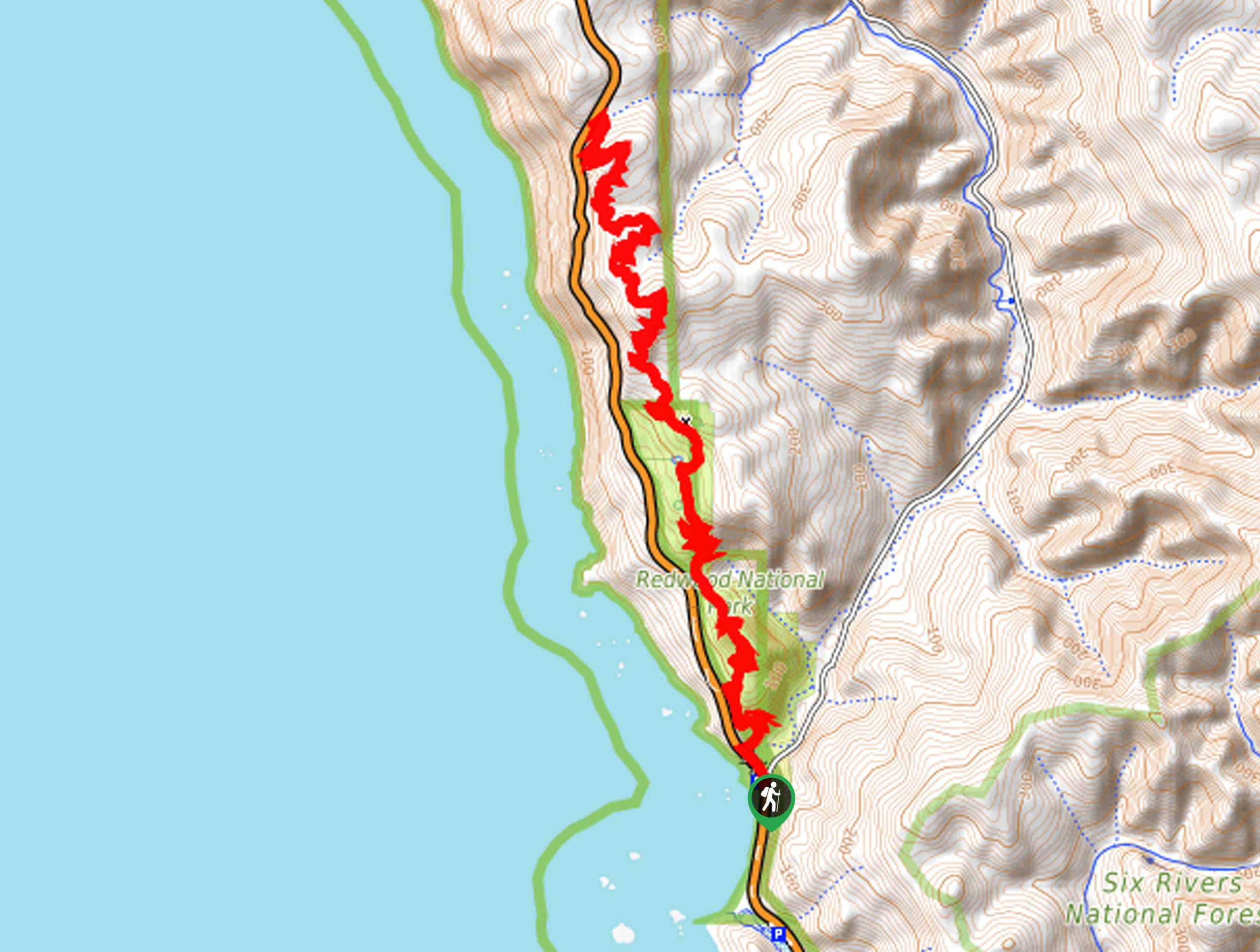
Coastal Trail: DeMartin Section
View Photos
Coastal Trail: DeMartin Section
Difficulty Rating:
Indulge in panoramic coastal views along the Coastal Trail: DeMartin Section. This intermediate hike boasts amazing scenery from beneath the tree canopy of looming redwoods and from exposed meadowlands. This trek is a must-add to your hiking itinerary—trust us!
Getting there
Find the trailhead at Wilson Creek Beach off the Redwood Hwy.

About
| Backcountry Campground | |
| When to do | Year-round |
| Pets allowed | No |
| Family friendly | Older Children only |
| Route Signage | Average |
| Crowd Levels | Moderate |
| Route Type | Out and back |
Coastal Trail: DeMartin Section
Elevation Graph
Weather
Coastal Trail: DeMartin Section Description
This trail is a moderately rated hiking route that traces the dramatic Pacific shoreline exposing amazing views of the ocean. Wander beneath the tree canopy of towering redwoods navigate the rocky and rootbound terrain. As this route is located near the ocean, it often sees extreme weather conditions, so we encourage you to check the forecast and prepare accordingly. Dressing in layers is highly recommended!
Setting out from the trailhead, the Coastal Trail: DeMartin Section tracks north along the Coastal Trail. The initial segment of the route is steep, guiding adventurers up a set of tightly wound switchbacks to the top of the coastal cliffs. Minding your footing on the terrain, the path will continue to gradually climb, passing the DeMartin Campground. At this point, the route will yet again demand the navigation of switchbacks before the terrain reaches a plateau.
Enjoy the panoramic ocean views from here and revel in the beauty of the encompassing woodlands. You will ultimately reach the end of your adventure at the intersection with the Redwood Highway. From here, retrace your footing along the path back to the trailhead.
Similar hikes to the Coastal Trail: DeMartin Section hike
Holter Ridge via Lost Man Trail
The Holter Ridge via Lost Man Trail is a popular mountain biking route in Redwood National Park—but it is open…
McArthur Creek Loop
Discover the beauty and diversity of Northern California’s coast along the McArthur Creek Trail. This challenging day hike exhibits the…
Mill Creek Horse Trail
Indulge yourself in the magical scenery of California’s coastal rainforests along the Mill Creek Horse Trail. This secluded adventure provides…
Comments