
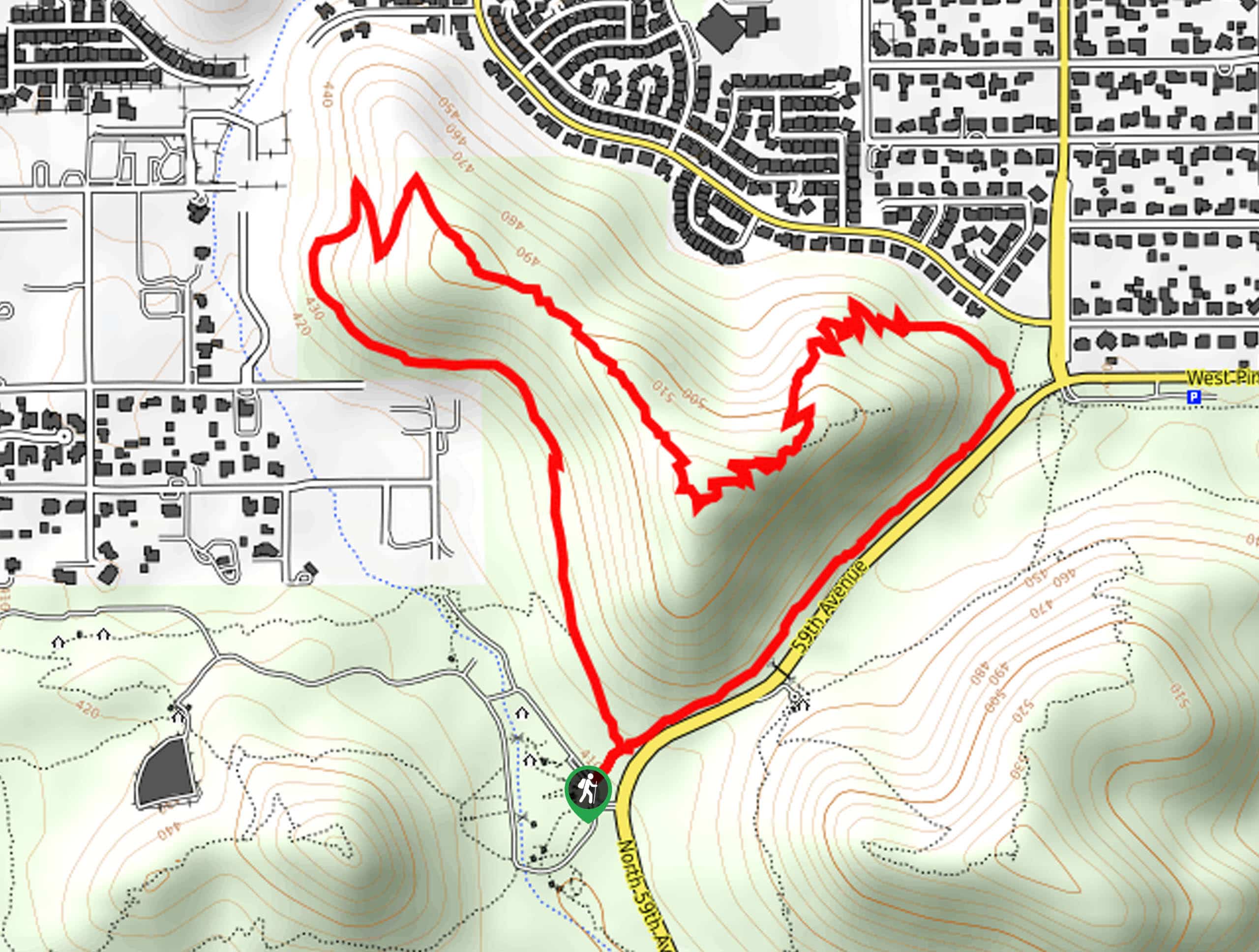
Cholla Loop
View Photos
Cholla Loop
Difficulty Rating:
The Cholla Loop is one of the three main trails in Phoenix’s Thunderbird Conservation Area, a recreational and natural area in the far northern reaches of the metro area near Glendale. This route climbs saguaro-dotted hills, follows a ridge with an excellent view of the city, and then returns you to the trailhead over the course of a moderately difficult hike.
The whole adventure is 3.5mi long and is suitable for most skill levels, including families and active beginners. Since this park is surrounded by a neighborhood, you’ll see lots of other families on the trail. The trail is obvious and easy to follow, so you shouldn’t need to bring along GPS routes or maps. A little tip: if you’re able to time your hike for the sunset, you’ll have the best view possible. Expect heavy traffic on this popular hike and consider visiting in off-peak hours if you’re able to.
Getting there
The trailhead for the Cholla Loop is off N 59th Avenue.

About
| Backcountry Campground | No |
| When to do | October-May |
| Pets allowed | Yes - On Leash |
| Family friendly | Yes |
| Route Signage | Average |
| Crowd Levels | High |
| Route Type | Loop |
Cholla Loop
Elevation Graph
Weather
Cholla Loop Description
The Cholla Loop is a pretty hike in the Thunderbird Conservation Park in the far northern suburbs of Phoenix, near the Glendale area. This park protects a hilly portion of the Sonoran Desert defined by rocky terrain and tall saguaros and it’s surrounded by neighborhoods, making it a super convenient hike if you happen to live in the areas surrounding the park. From the ridge, you’ll have a nice view of the city and the mountains that surround it.
The route is easy to follow and suitable for most skill levels, making this a fun one for weekend mornings when you want a short hike with a solid reward. Since the path itself is obvious and well-maintained, you shouldn’t require any navigational aids.
Expect heavy traffic on this popular trail. If you’re able to visit outside of peak hours (which would be weekend mornings), you’ll have more of the trail to yourself. For the best views, try this hike during sunset if you can!
This route might be a bit tough for total beginners, little kids, and hikers with mobility challenges as there are some sections of steeper trail, but the climbs don’t last very long. Make sure you bring water with you and avoid hiking during the hottest part of the day.
Our loop goes counterclockwise. From the trailhead, take H1 Trail as it follows the base of the hill northeast. At the junction, stay left and then begin your switchbacks up the ridge. This is the most challenging part of the hike. You’ll climb steadily through the turns, plateauing partway through the climb before the final stretch to the highpoint of the hike.
Once you make it atop the ridge, take some time to enjoy the views. Phoenix stretches out in front of you to the south and the desert sprawls to the north.
Follow the ridgeline to the northwest, admiring the saguaros on the slopes below you. You’ll be heading gently downhill until reaching a couple of wide switchbacks. Follow these down to the bottom of the ridge.
From here, follow H3 Trail back to the trailhead by hugging the base of the hill and hiking southeast.
Hiking Route Highlights
Thunderbird Conservation Park
The Thunderbird Conservation Park is a regional park in Glendale, Arizona. It covers 1,185 acres in the Hedgpeth Hills and serves to protect and preserve this area’s natural environment. The hills were named after Robert Hedpeth, an early homesteader in the area. The park is named for the WWII pilot training facility that was located four miles south of the area. The park offers space for picnicking, hiking, horseback riding, mountain biking, running, and birdwatching over 15.0mi of multi-use trails.
Frequently Asked Questions
Does the Thunderbird Conservation Park close?
Yes, the park opens at sunrise each morning and closes at sunset each evening.
Are dogs allowed on Cholla Trail?
Yes. Dogs are permitted on this hike on leash. There are some areas in the park where they’re permitted to be off-leash.
Where is the entrance to Thunderbird Conservation Park?
The main entrance to the park is on 59th Avenue between Deer Valley and Pinnacle Peak.
Insider Hints
Bring lots of water on this hike, there’s no shade on the trail.
Evening visits to the park can offer less busy trails and cool enough temperatures.
Similar hikes to the Cholla Loop hike

Palisade to Basalt Loop
The Palisade to Basalt Loop is a short, easy trail in the Deem Hills Recreation Area. This hike is 1.4mi

Two Bit and Rattle Saddle Loop
The Two Bit and Rattle Saddle Trail is a moderately challenging hike in the Phoenix’s Mountain Preserve near Piestewa Peak.…

Ma-Ha-Tauk and Crosscut Loop
The Ma-Ha-Tauk and Crosscut Loop is a moderate hike in Phoenix’s South Mountain Preserve. With pleasant views and not much…
Comments