Aravaipa Canyon Trail
View Photos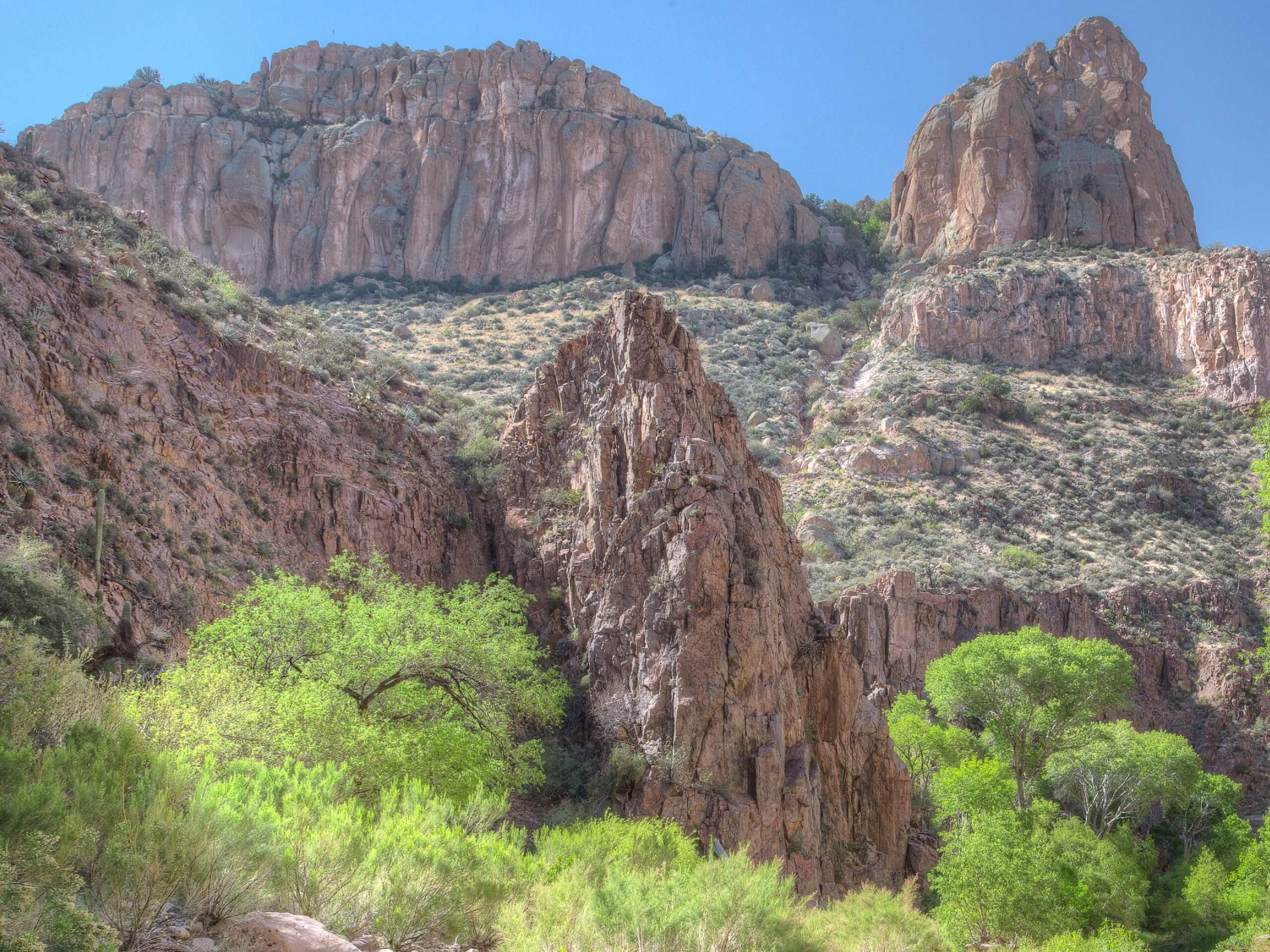
Aravaipa Canyon Trail
Difficulty Rating:
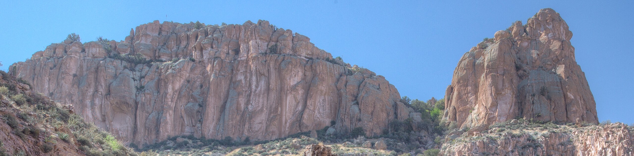
The Aravaipa Canyon Trail is a 9.5mi hike in the Aravaipa Canyon Wilderness southeast of Phoenix, Arizona. This trail is special! It meanders through a beautiful canyon with dramatic walls, lots of wildlife, cacti, and occasionally lush trees all around you. You’ll need a permit for this trail, and even though the permits usually sell out, the trail often feels very solitary. You can camp along this route, too.
The hike is quite easy with little elevation gain, but the difficulty rating comes from the length and the number of creek crossings you’ll complete. You’ll want to be wearing shoes that can handle ankle-deep water throughout the hike. Expect moderate traffic and remember that dogs aren’t permitted on this hike.
Getting there
The trailhead for the Aravaipa Canyon Trail is on E Aravaipa Road.

About
| Backcountry Campground | Various backcountry spots |
| When to do | October-May |
| Pets allowed | No |
| Family friendly | Older Children only |
| Route Signage | Poor |
| Crowd Levels | Moderate |
| Route Type | Out and back |
Aravaipa Canyon Trail
Elevation Graph
Weather
Aravaipa Canyon Trail Description
Aravaipa Canyon Trail is a 9.5mi route that travels along the floor of a gorgeous cliff-bound gorge southeast of Phoenix. This hike passes through a wide, wooded area into the gorge, the rocks changing from volcanic to conglomerate. There are cacti, trees, and wildlife to see along the way. You can also go further along this trail than our guide reflects or turn back early if you need a shorter hike.
You’ll need a permit for this hike and the amount of permits offered per day is limited. Permits tend to sell out so make sure you secure your permit ahead of time. Although the permits tend to sell out, it still feels very remote on this trail. Permits can be reserved up to 13 weeks ahead of time and backpackers can stay up to two nights.
This wilderness area is rugged. There is no signage, no designated campsites, and no facilities. Come prepared with everything you need. You can filter water along the way, but just be prepared for a hike with no services. The canyon is easy to follow but we recommend downloading a GPS track just to be safe.
You’ll complete many stream crossings on this hike and the water is usually ankle to knee-deep. You simply won’t be able to keep your feet dry at all, so consider neoprene socks, sandals, or some other water-suitable footwear.
We don’t recommend hiking this route in the summer months (June-August) for a couple of reasons: the weather can be extremely hot despite the shade available, and the creek is subject to flooding from summer monsoons. Try your hike in the spring or the fall.
From the trailhead, the route heads towards the creek and takes a left. Where the creek splits the first time, stay right.
There are lots of side canyons, caves, chimneys, and windows to see on the way. You could spend your full three allotted days out here exploring all the canyons if you wanted to, but shorter trips still satisfy with great views and unique landscapes.
Hell’s Half Acre Canyon will connect on your right shortly. Right after, Cave Canyon connects on your left. The next major canyon is Javelina on your left, which some casual hikers use as a turnaround point.
Our route ends shy of 5.0mi into the canyon, but know that you could continue further if you wanted to. Horse Camp Canyon is ahead on your left, which some users camp in. However far you go, you’ll simply turn around and retrace your steps to the trailhead once you’re ready.
Hiking Route Highlights
Aravaipa Canyon Wilderness
The Aravaipa Canyon Wilderness is 19,410 acres of wild, unique landscapes. With a creek that flows year-round (a rarity in this hot, dry state), this canyon and the surrounding wilderness support a diverse range of plants and animals not usually found in such abundance elsewhere in the state. With a vibrant riparian habitat, dramatic canyons, rugged trails, and interesting natural features, exploring the Aravaipa Canyon Wilderness simply doesn’t disappoint.
Frequently Asked Questions
Can you drive through Aravaipa Canyon?
No, you cannot drive through the canyon.
Is there water in Aravaipa Canyon?
Yes! This is one of the few areas in the Sonoran Desert where water flows year-round.
What does Aravaipa mean?
Aravaipa is an Apache word that is commonly understood to mean “laughing waters.”
Insider Hints
Should you come on horseback, note that you cannot stay overnight.
Groups are limited to 10 people at a time.
Similar hikes to the Aravaipa Canyon Trail hike

Palisade to Basalt Loop
The Palisade to Basalt Loop is a short, easy trail in the Deem Hills Recreation Area. This hike is 1.4mi

Two Bit and Rattle Saddle Loop
The Two Bit and Rattle Saddle Trail is a moderately challenging hike in the Phoenix’s Mountain Preserve near Piestewa Peak.…

Ma-Ha-Tauk and Crosscut Loop
The Ma-Ha-Tauk and Crosscut Loop is a moderate hike in Phoenix’s South Mountain Preserve. With pleasant views and not much…
Comments