Tegg’s Nose and Macclesfield Forest
View Photos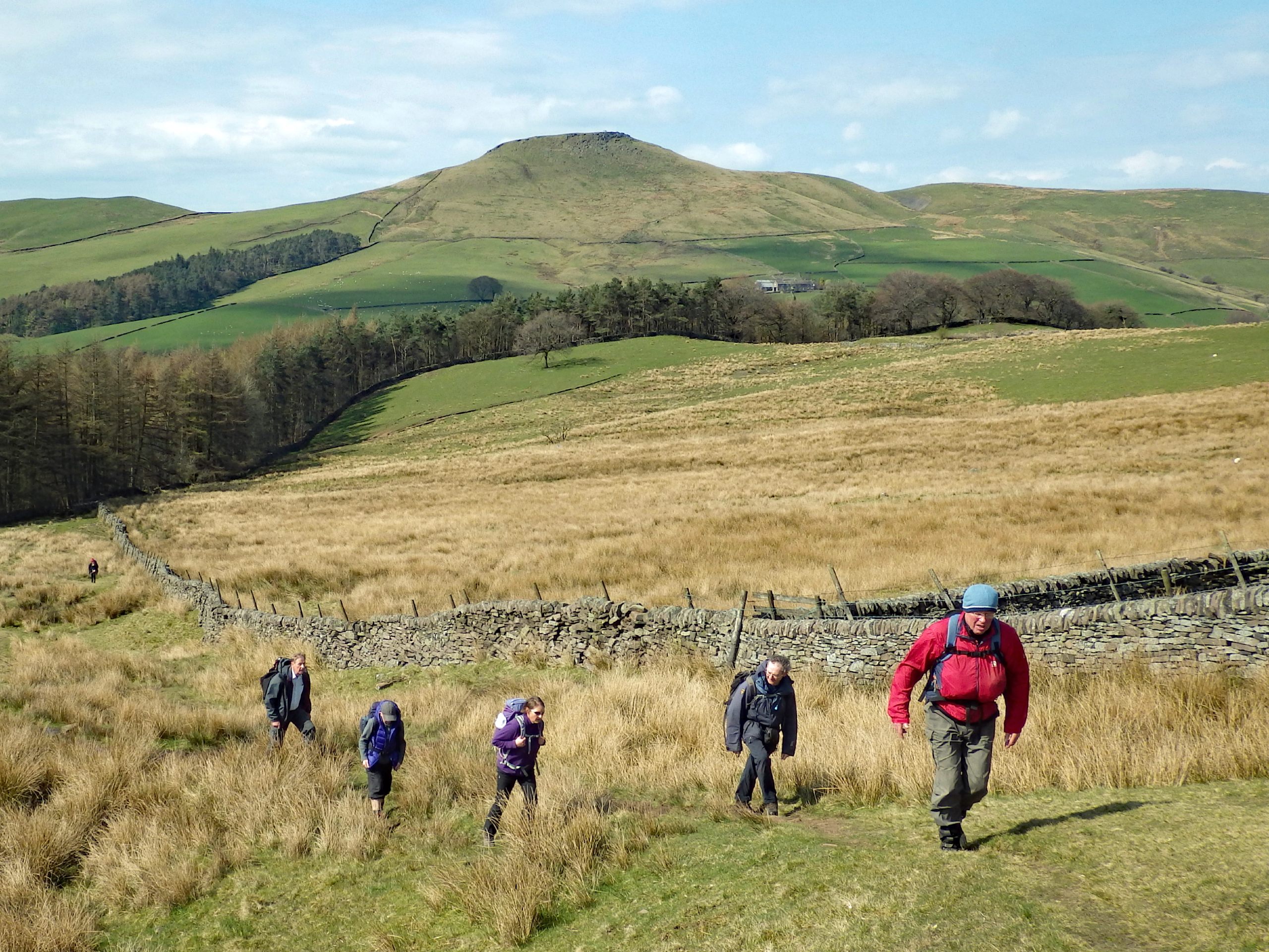
Tegg’s Nose and Macclesfield Forest
Difficulty Rating:
Walking the Tegg’s Nose and Macclesfield Forest Trail will take you on an amazing journey through breathtaking forests and up to the top of one of the most iconic hills in the area. Along the walk, you will traverse a variety of terrain, including stretches of woodland, rugged hilltops, and meadow, as you take in some spectacular views across the Cheshire countryside. While the route does feature a bit of uphill walking, it is not overly difficult and can be completed by casual and seasoned walkers alike.
Getting there
To reach the Tegg’s Nose and Macclesfield Forest trailhead from the village of Langley, head east on Main Road for 0.2mi and continue straight onto Clarke Lane. After 0.6mi, turn right to find roadside parking next to the trailhead. Alternatively, there is a car park a bit further on into the forest.

About
| When to do | March-October |
| Backcountry Campsites | No |
| Pets allowed | Yes - On Leash |
| Family friendly | Yes |
| Route Signage | Average |
| Crowd Levels | Moderate |
| Route Type | Circuit |
Tegg’s Nose and Macclesfield Forest
Elevation Graph
Weather
Tegg’s Nose and Macclesfield Forest Trail Description
The Tegg’s Nose and Macclesfield Forest trail is a fairly popular walking route in an area that offers access to a number of outdoor activities, meaning there is likely to be a large volume of people utilizing the trails and car parks. Make sure to arrive early enough to secure parking, or else you will need to find an alternative close by. Additionally, this route does feature some steep sections of trail that are uneven and might have some loose rock. While you can complete the walk in runners, it is best to bring proper boots with ankle support to stay comfortable along the trail.
As mentioned, the trails within close proximity to Tegg’s Nose and the Macclesfield Forest can become very busy, and it is for good reason. Along this walk, you will be exposed to several types of terrain that include steep climbs up the hillside and leisurely strolls through the woodland landscape near the reservoirs. With the opportunity to soak up the natural beauty of the Cheshire landscape and spot some of its lovely plant and animal life, a quick spell along this walking route should absolutely make it into your diary for the next time you are in the Macclesfield area.
Setting out on a walk that begins next to a pub is always risky business, as there is a fair chance that the entire venture could get scratched before it even begins; however, we’ll assume that’s not the case here and head west along west along Clarke Lane, passing by the Leather’s Smithy pub on your right. After 0.4mi, turn right towards Bottoms Reservoir and follow the trail as it leads across the dam wall and crosses over a bridge.
Once you are across, pass through the gate and head left to follow along the dam wall of Tegg’s Nose Reservoir. Enter into the shady canopy of the forest and take the path to the left, passing through a series of kissing gates to begin your climb uphill toward Tegg’s Nose. After 0.3mi, go right at the junction, followed by a left to eventually arrive at a gate. Pass through the gate and turn right, following the path for 150ft. Keep right at the fork to wind your way downhill through the tree cover and follow the stone wall towards the farm. Pass through the gate and continue on to meet up with the road, passing straight through to follow Forest Road to the northeast.
Keep on along Forest Road as it bends to the right and winds through the countryside for 0.6mi, where you will spot a gate on your right. Follow this path and make your way through the gate to walk through a wonderfully calm stretch of woodland terrain, keeping an eye out for any deer that might be spotted in the area. Pass straight through the first junction and turn right at the four-way intersection onto the Forest Bridleway. Keep straight along this portion of the walk for 0.7mi, as you meander along the edge of the forest with open fields on your right side.
Once you have reached the gate, pass through and head right to follow the road for 0.4mi along the edge of the dense forest until you arrive back at the Leather’s Smithy pub where you began. From here, you can continue to explore the strong network of trails that pass through the serene forest and take in the sights along the edge of the reservoir, or you can head into the pub for a quick pint to celebrate having completed the Tegg’s Nose and Macclesfield Forest Walk.
Trail Highlights
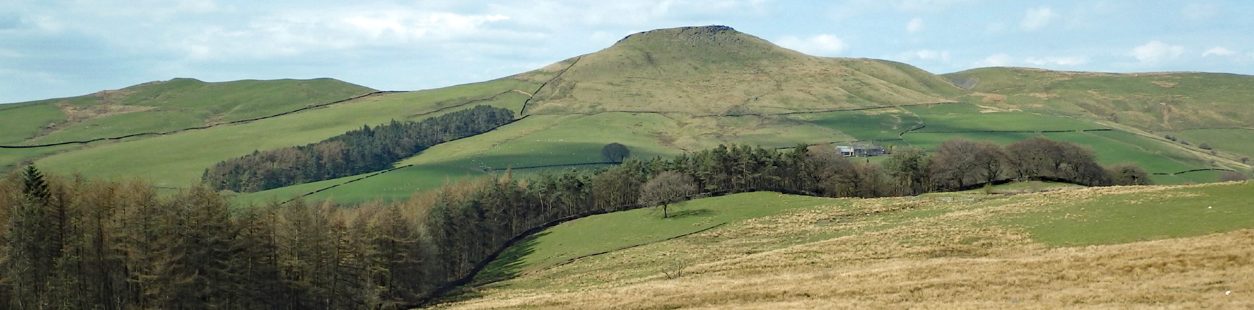
Tegg’s Nose
Tegg’s Nose is an iconic hill in the Macclesfield area with a rich history and commanding view over the surrounding Cheshire landscape. The area surrounding the hill is thought to have been inhabited since the Bronze Age and it would later be incorporated into the Royal Forest of Macclesfield, a prominent hunting ground for nobility after the Norman COnquests. The ridge has a high point of 1247ft and is composed of gritstone deposits that were mined between the 16th and 20th centuries.
Macclesfield Forest
The last remaining portion of the historic Royal Forest of Macclesfield, this woodland area is now part of a nature reserve, operating in direct contrast to its historic use as a hunting ground for nobility. In modern times, various local animal species can still be found here, including red deer and heron. The wood is primarily made up of conifer trees.
Frequently Asked Questions
Why is it called Teg’s Nose?
Possible answers are not concrete; however, early maps of the area refer to the hill as Tegge’s Naze. Tegge could have been a Norse settler and nose would mean a promontory or high point of the landscape.
Other amazing walks in Peak District National Park
Check out our guides to Kinder Scout, Mam Tor, Stanage Edge, Dovedale, and Padley Gorge. Or see all of our Peak District walks on 10Adventures.
Insider Hints
Arrive early to secure parking.
Pop in to the Leather’s Smithy pub for some pre or post-walk refreshments.
Weather atop the hill can change quickly, so come prepared with any gear that you might need.
Similar hikes to the Tegg’s Nose and Macclesfield Forest hike

Valehouse Reservoir Circular
The Valehouse Reservoir Circular is a 3.1mi lollipop trail near Glossop that travels around the edge of the…

Three Edges Walk
The Three Edges Walk is a challenging circuit in Derbyshire that will take you along three escarpments that offer some…

Edale Rocky Ridges Walk
The Edale Rocky Ridges Walk is just that - an adventurous walk along a rugged ridgeline. While out on the…
Comments