Bamford and Stanage Edge Circular Walk
View Photos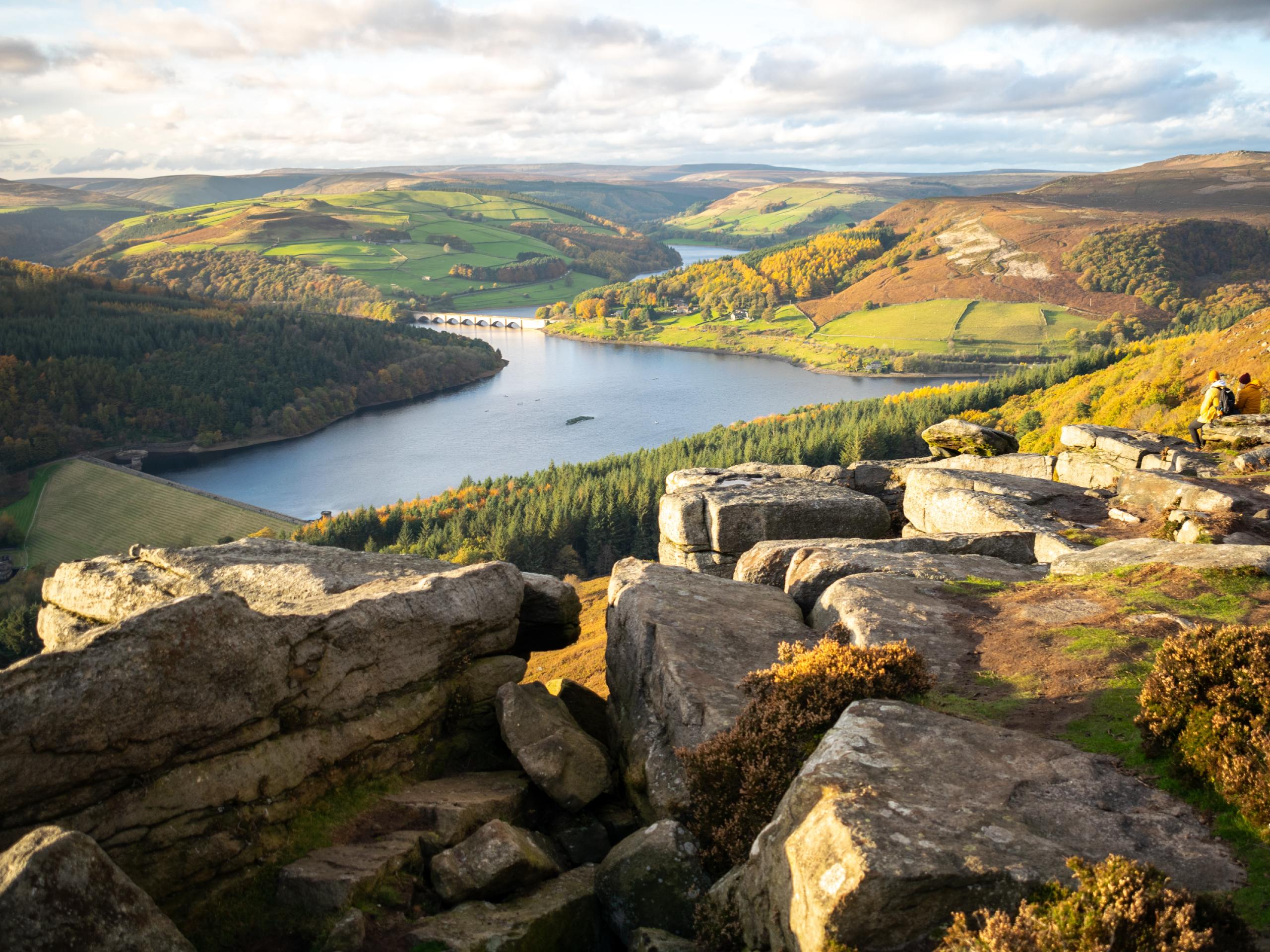
Bamford and Stanage Edge Circular Walk
Difficulty Rating:
The Bamford and Stanage Edge Circular Walk will take you along the edge of these two rugged escarpments for some amazing views across the surrounding valleys and moorland. Relatively easy to navigate, the route passes through a variety of terrain and will allow you to explore the rugged landscape that is home to some of the Peak District’s most challenging and alluring rock climbing routes. Get set for an awesome day of exploring the outdoors along a route that is suitable for casual and seasoned walkers alike.
Getting there
To reach the car park for the Bamford and Stanage Edge Circular Walk from Hathersage, head west on Main Road/A6187 for 250ft and turn right onto Jagger’s Lane. After 0.2mi, turn right onto Coggers Lane, following it for 1.6mi and continuing straight for another 0.2mi to arrive at the car park.

About
| When to do | March-October |
| Backcountry Campsites | No |
| Pets allowed | Yes - On Leash |
| Family friendly | Older Children only |
| Route Signage | Average |
| Crowd Levels | Moderate |
| Route Type | Circuit |
Bamford and Stanage Edge Circular Walk
Elevation Graph
Weather
Bamford and Stanage Edge Circular Walk Description
While the Bamford and Stanage Edge Circular Walk traverses some elevated terrain and offers amazing views across the valley, there actually isn’t all that much in the way of difficult-to-navigate or overly steep terrain. Make sure to exercise caution when traversing the rugged areas near either edge, as strong gusts of wind could potentially prove dangerous. Additionally, try to arrive early, as the car park is small and the route becomes busy during peak times.
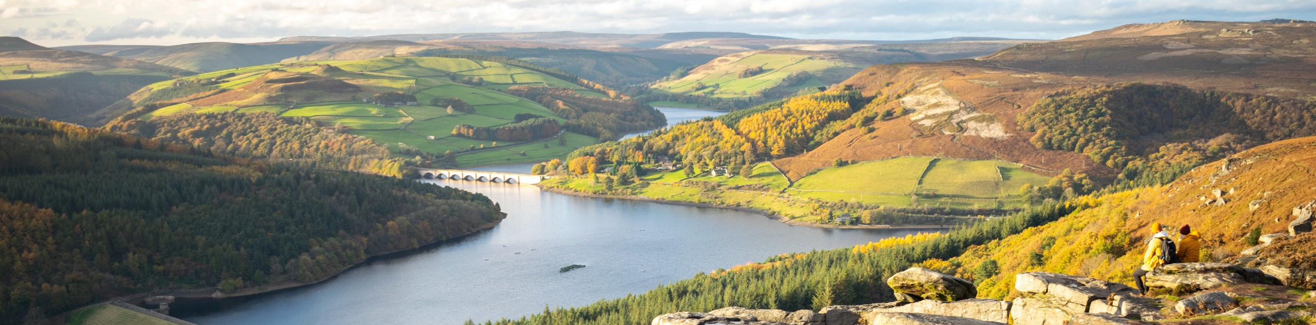
With such well-maintained pathways and fairly easy terrain, this walk is perfectly suitable for walkers of all skill levels, including families with children. Along the walk, you will be exposed to some truly breathtaking views that will allow you to look out over the surrounding moors, the Hope Valley to the south, and Ladybower Reservoir with the beautiful Ashopton Viaduct stretching across the water to the west. If you have a few spare hours and are looking to explore the natural beauty of Peak District National Park, then this walking route should definitely make it onto your list.
Setting out from the car park, head to the left and make your way to the southwest along the Long Causeway, keeping right for 1.0mi until you arrive at a small gate next to a layby on your right. Pass through the gate and keep left along the trail, where you will shortly arrive at a fork. Take the path to the right to begin your climb up to Bamford Edge, where you will have an amazing view overlooking Hope Valley, Bamford, and Ladybower Reservoir.
Continue along the path for 0.3mi, turning left at the junction to skirt around Great Tor on a route that will bring you closer to the edge. Turn right at the next junction and enjoy the scenic views over the rolling green terrain for the next 0.5mi, where you will head right at the fork. Continue straight for 0.4mi and take in the views of Ladybower Reservoir to your left, with the impressive Ashopton Viaduct gracefully stretching across its calm water.
Keep left at the next fork, followed by a series of right and left turns that will take you over a stream and bring you to the Rivelin Tunnel Sighting Towers that were used to survey the construction of the Rivelin Tunnel. Continue along the path for 0.6mi as it gently descends the hill and crosses over Jarvis Clough, eventually meeting up with a junction. Take the path to the right, followed by another right to come to another fork in 0.1mi. Head left, and after climbing uphill over the next 0.6mi, you will arrive at Stanage Edge.
Follow the path to the right to walk along Stanage Edge and take in the amazing views stretching out from the rocky escarpment and into the valley below. As you stroll along the path, you will likely pass by some climbers heading out to navigate the many challenging routes that can be found along the edge of the cliff.
After 0.8mi of walking along Stanage Edge, you will pass by the high point of the escarpment known as High Neb, and shortly after this there will be a trail branching off to the right. Take this and follow it south for 0.3mi while descending the hill to cross over a stile and meet back up with the Long Causeway. From here, follow the road to the right to return to the car park where you began your journey. After wrapping up the Bamford and Stanage Edge Circular Walk, you can either head home or make your way into the nearby village of Hathersage to further explore the area or stop by the pub to refuel after your walk.
Trail Highlights
Stanage Edge and Bamford Edge
Stanage Edge and Bamford Edge are two gritstone escarpments within the Peak District that can be found just west of Sheffield and provide a commanding view of the surrounding landscape. Both places are popular destinations for rock climbers, due to the craggy rock faces and naturally weathered gritstone that make up the cliff. Stanage edge is particularly notable, being the home to the UK’s longest recorded route, the 16404ft Girdle Traverse.
Frequently Asked Questions
How was Stanage Edge formed?
The sedimentary rock formations that can be found throughout the Peak District were formed over 350 million years ago, when vast river deltas were widespread and deposited sediment in the area.
Other amazing walks in Peak District National Park
Check out our guides to Kinder Scout, Mam Tor, Stanage Edge, Dovedale, and Padley Gorge. Or see all of our Peak District walks on 10Adventures.
Insider Hints
Arrive early to secure parking, as spaces at the trailhead are limited.
There are no toilet facilities at the trailhead.
The trail can be a bit wet and boggy in certain places, so make sure to wear proper footwear.
If you want to avoid some of the crowds along the trail, try walking it in the reverse direction.
Stop into the nearby historic village of Hathersage to visit Charlotte Bronte’s old stomping grounds and view the resting place of Robin Hood’s pal Little John.
Similar hikes to the Bamford and Stanage Edge Circular Walk hike

Valehouse Reservoir Circular
The Valehouse Reservoir Circular is a 3.1mi lollipop trail near Glossop that travels around the edge of the…

Three Edges Walk
The Three Edges Walk is a challenging circuit in Derbyshire that will take you along three escarpments that offer some…

Edale Rocky Ridges Walk
The Edale Rocky Ridges Walk is just that - an adventurous walk along a rugged ridgeline. While out on the…
Comments