
Higger Tor Circular Walk
View PhotosHigger Tor Circular Walk
Difficulty Rating:
The Higger Tor Circular Walk is a fun, family-friendly outing just west of Sheffield that will take you on an 5.1mi trek through the Hathersage Moor for some amazing views of the surrounding countryside. Along the walk, you will be able to visit several unique historical sites and summit Higger Tor, a rock promontory that was featured in The Princess Bride (1987). The trails here are easy to follow and suitable for walkers of most skill levels, including families with children. The route is also dog friendly.
Getting there
To reach the car park for the Higger Tor Circular Walk from the village of Hathersage, head east along Main Road/A6187 for 3.1mi and turn right onto Owler Bar Road. After 0.1mi, you will find the car park on the right.

About
| When to do | March-November |
| Backcountry Campsites | No |
| Pets allowed | Yes - On Leash |
| Family friendly | Yes |
| Route Signage | Average |
| Crowd Levels | Moderate |
| Route Type | Circuit |
Higger Tor Circular Walk
Elevation Graph
Weather
Higger Tor Circular Walk Description
There aren’t many reasons to fault the Higger Tor Circular Walk, as it is a solid walking route that is well-maintained. There are a couple of boggy sections along the return portion of the walk after Carl Wark, so make sure to wear proper walking footwear to stay comfortable. Additionally, the trail is dog-friendly but please remember to keep them on leash, as there are free-roaming animals in the area.
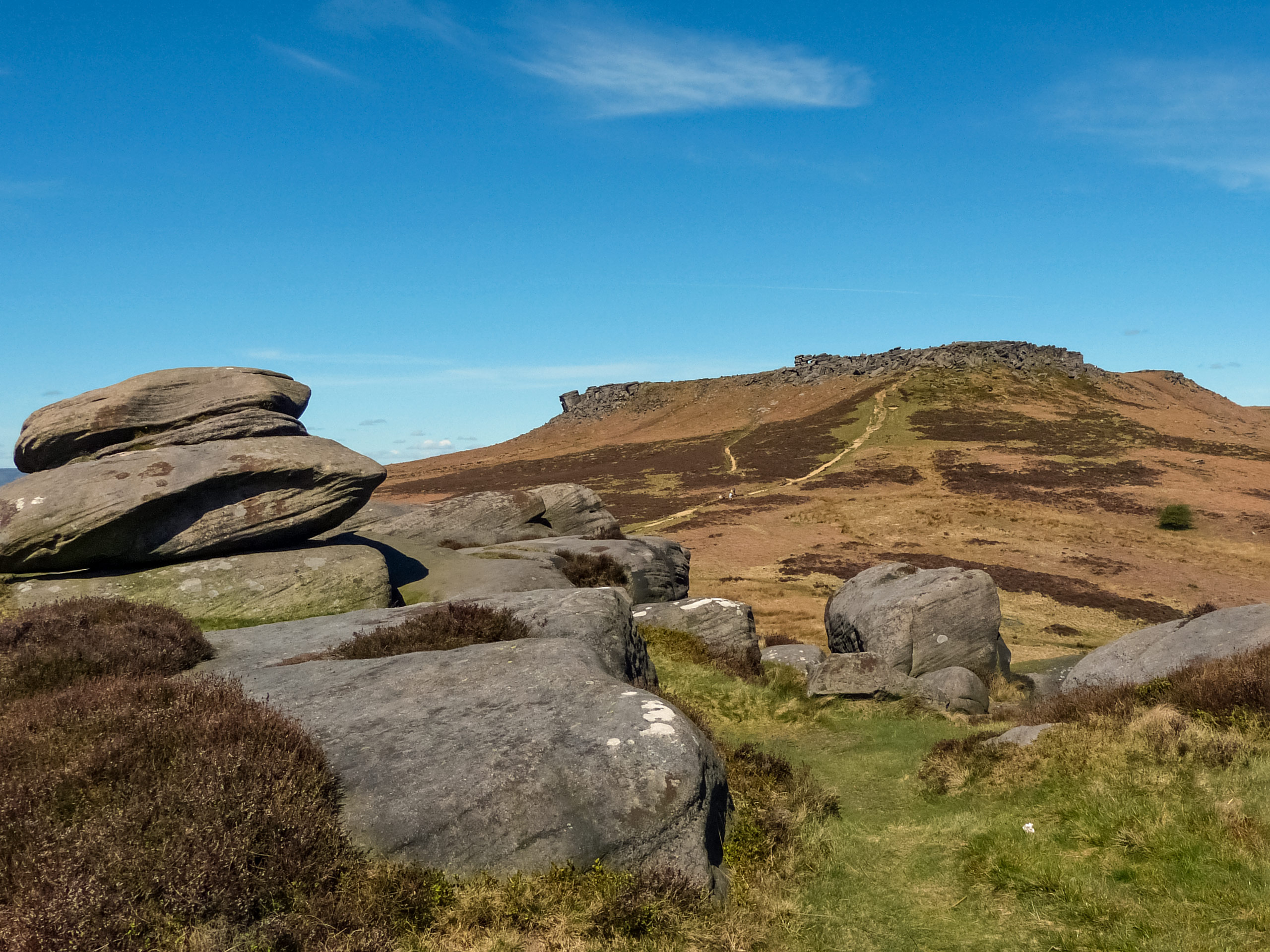
With several unique historical and pop culture sites, easy to navigate trails, and breathtaking views across the Hathersage Moor, it is no wonder that the Higger Tor Circular Walk is a popular destination for both locals and visitors alike. The route passes through the scenic Burbage Valley, crossing over Burbage Brook at a point where the army used to conduct shooting drills during WWII. Then, the path climbs up the moor to the summit of Higger Tor, where you will have a commanding view over the scenic countryside. On the return leg of the walk, you will make your way to the presumed Iron Age fort at Carl Wark, before returning to the car park. There’s a lot to see along this route, so it’s best just to dive right in!
Setting out from the Woodcroft car park at the Longshaw Estate Visitor’s Centre, make your way west along the trail towards the Longshaw Estate buildings. Reaching a junction with the lane, follow it to the right for 0.1mi and cross over B6521. Picking up the path on the opposite side, pass through the gate and head into the wood. At the fork, keep right and pass through another gate to make your way over Hathersage Road toward the track on the opposite side.
Pass through the gate here and continue on for a short distance to a kissing gate. Make your way through and keep straight along the wide walking path, as you meander through the rock strewn expanse of Burbage Valley for 0.7mi. Shortly after passing by a small spring on your right, you will come to a series of crossings over the brook. Keep on for another 0.9mi, as you enjoy the calm of the picturesque English countryside and eventually end up near the Burbage Bridge with a small car park on your right.
Carefully navigate the slightly rocky terrain along the edge of the brook, as you pass under the Burbage Bridge and skirt around a larger car park that is now on your right. Upon investigation of the countless stones scattered across the area, you will notice many small holes that are the result of army shooting drills that were conducted here during World War II.
Reaching the junction next to the car park, turn left, followed by an immediate right to climb uphill along the moor towards Higger Tor. Keep left for 0.6mi to arrive at an intersection surrounded by scattered gritstone rocks. From here, there are several pathways that lead up to the summit of Higger Tor, so spend some time exploring the area and take in the breathtaking views that stretch across Burbage Valley below, as well as the next stop on the journey, Carl Wark.
After taking in the sights, make your way southeast along the trail to descend Higger Tor on the somewhat steep route towards Carl Wark. Keep left for 0.2mi before heading right at the fork. After a quick left, you can make your way up to the top of the rock promontory that is believed to be the site of an Iron Age fort due to the fact that the cliffs and built up embankment form an enclosure.
Head south along the trail here, following it for 0.2mi as you descend the hill and come to a junction on your right. Take this path and cross over the boggy terrain to pick the trail back up on the opposite side. Head left, and continue on to the south for 0.2mi to reach a fork. Go right here and after a short distance turn left to pass through a gate and arrive at the side of the road. Follow the road left for 0.1mi as it turns round a bend. On the opposite side of the road you will see a gated path. Make your way over and pass through the gate to continue on the final leg of the walk.
Once you have come to a fork at the edge of a stream, take the path to the left and cross over the bridge. From here, continue southeast along the trail to pass through a gate, keeping straight through the junction to meet back up with the original trail that will lead you back toward the Longshaw Estate Visitor’s Centre. After wrapping up the Higger Tor Circular Walk, stop in to explore the visitor’s centre or pop into the tea room for some refreshments before heading home.
Trail Highlights
Higger Tor
Higger Tor is a large, free-standing gritstone rock formation in the Peak District that overlooks the Burbage Valley and the nearby presumed Iron Age fort of Carl Wark. A well-known landmark just southwest of Sheffield, Higger Tor was featured in a scene of the 1987 film The Princess Bride.
Carl Wark
Carl Wark is a rock promontory that can be found along the Hathersage Moor just west of Sheffield. Although the date and purpose of the construction atop the hill is unknown, the cliffs and embankment are thought to make up an enclosure that could have once been an Iron Age fort.
Other amazing walks in Peak District National Park
Check out our guides to Kinder Scout, Mam Tor, Stanage Edge, Dovedale, and Padley Gorge. Or see all of our Peak District walks on 10Adventures.
Insider Hints
This walking route can be busy at times, especially on weekends or bank holidays. Make sure to arrive early enough to secure parking.
This route is perfect if you are into unique historical features. Carl Wark is presumed to have been an Iron Age fort, and the Burbage Rocks near the bridge are dotted with bullet holes from army drills during WWII.
Sections of the trail can be a bit boggy. Remember to wear proper walking footwear to stay comfortable along the trail.
Similar hikes to the Higger Tor Circular Walk hike

Valehouse Reservoir Circular
The Valehouse Reservoir Circular is a 3.1mi lollipop trail near Glossop that travels around the edge of the…

Three Edges Walk
The Three Edges Walk is a challenging circuit in Derbyshire that will take you along three escarpments that offer some…

Edale Rocky Ridges Walk
The Edale Rocky Ridges Walk is just that - an adventurous walk along a rugged ridgeline. While out on the…
Comments