Shining Tor Circular Walk
View Photos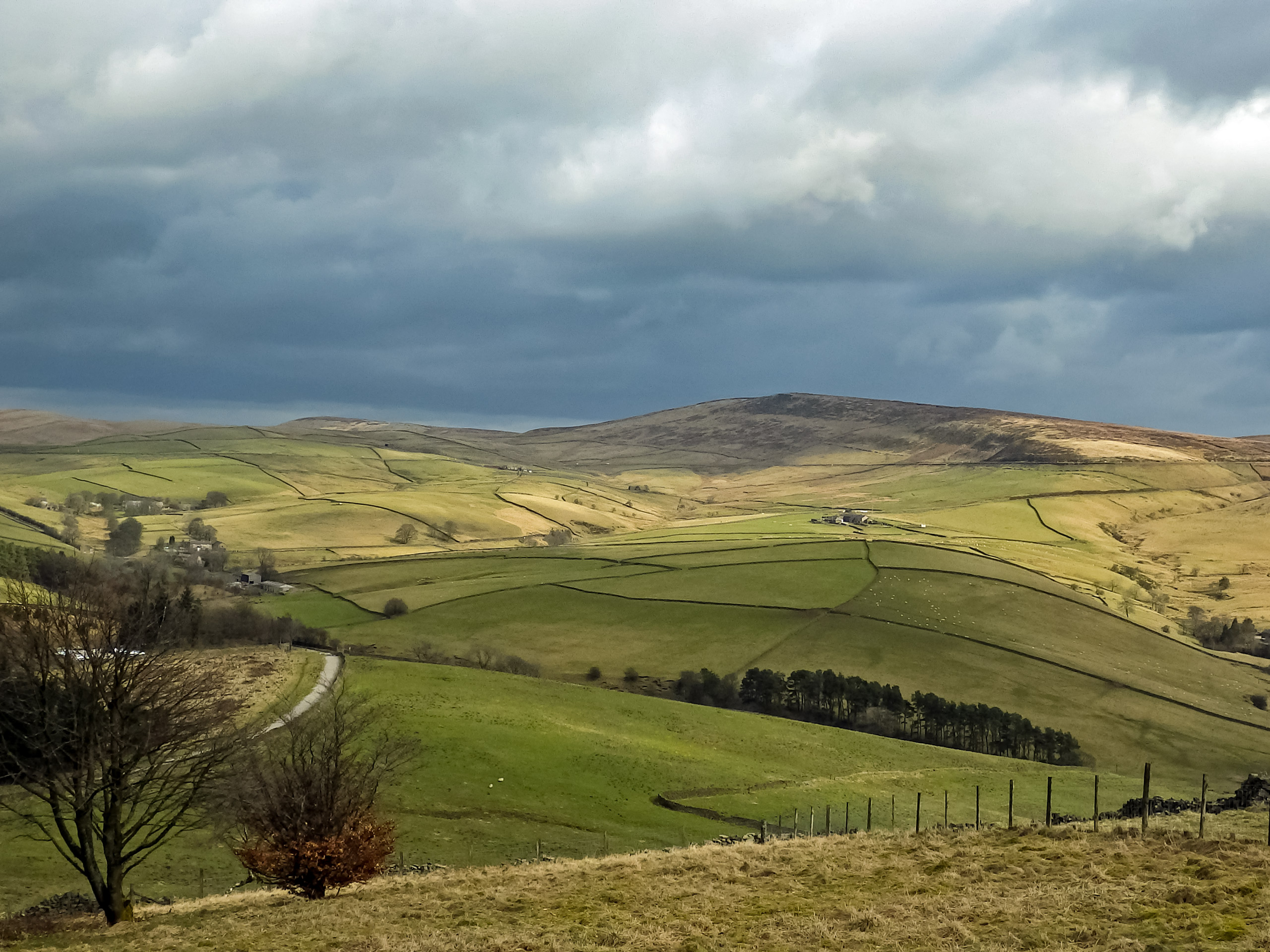
Shining Tor Circular Walk
Difficulty Rating:
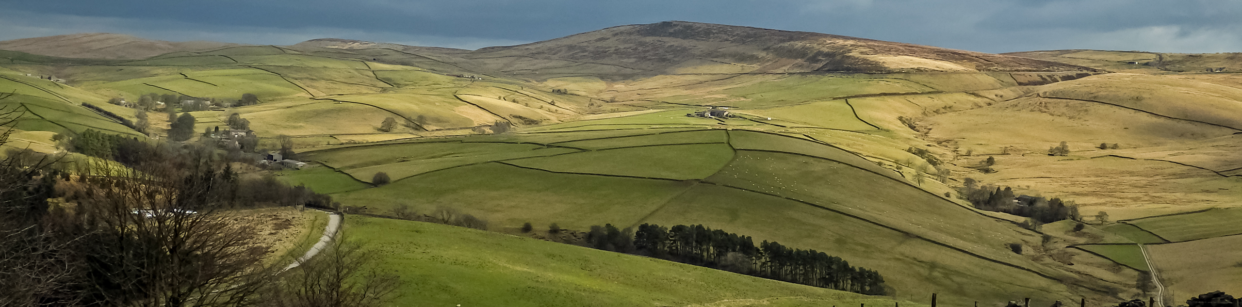
The Shining Tor Circular Walk is a fantastic walking route on the border of Cheshire and Derbyshire that climbs uphill through the forest to summit the two peaks of Shining Tor and Cats Tor. While out on the trail, walkers will pass by several interesting features including the ruin of Errwood hall and the Shrine of St. Joseph. Although the beginning of the walk is steep, the latter half is all downhill, making for a not-so-difficult route with some amazing points of interest.
Getting there
To reach the trailhead for the Shining Tor Circular Walk from Buxton, drive west on Manchester Road/A5004 for 1.0mi and make a slight left turn onto Goyt’s Lane. In 1.0mi, turn left at The Street and you will find the car park on the right in 0.0mi.

About
| When to do | Year-Round |
| Backcountry Campsites | No |
| Pets allowed | Yes - On Leash |
| Family friendly | Older Children only |
| Route Signage | Average |
| Crowd Levels | Moderate |
| Route Type | Circuit |
Shining Tor Circular Walk
Elevation Graph
Weather
Shining Tor Circular Walk Description
The Shining Tor Circular Walk features a fairly steep climb uphill that will see you summit the peaks of both Shining Tor and Cats Tor. Because of this, walkers should be prepared for a bit of a leg burn and make sure to wear proper walking footwear for the journey. Additionally, trail conditions can be wet and muddy, especially during the spring/autumn seasons.
With several unique historical sites along the trail and the amazing views overlooking the surrounding landscape from two peaks, the Shining Tor Circular Walk is a prime example of a route that will have a bit of something for everyone. If you are looking for a bit of a workout, the initial portion of the walk features a steep uphill climb that is sure to get your heart pumping, and if that isn’t really your thing, the latter half is all downhill. Located within the iconic Peak District, this scenic walking route offers the perfect blend of awesome views and historical sightseeing.
Setting out from the car park, follow the well-groomed path to the west as it passes through a stretch of open terrain and enters into the cover of the forest. Keeping right along the trail, you will eventually arrive at the site of the Ruin of Errwood Hall that was built in the 1830’s by Samuel Grimeshawe. Once the centre of a thriving estate in the area, the hall was demolished and the stones used to aid in building the Fernilee Reservoir in 1934.
After exploring the ruins of the once-grand building, continue along the trail as it heads west for 0.2mi and arrives at a junction near some stairs. Turn right and make your way along the steps for a short distance, taking the first path to the left. From here, follow the trail as it climbs uphill along Foxlow Edge for 0.7mi, eventually arriving at the quaint Chapel of St. Joseph on the edge of a large wood.
Make your way past the chapel and head left at the next junction, keeping left until you meet up with a small car park along The Street. Pass through the gate and turn right along the road, following it uphill for 0.5mi, where you will find a trail on the left. Follow this and head through the gate, continuing on for 0.5mi to take either path at the junction on the approach to the summit of Cats Tor. Take some time to enjoy the breathtaking views that sweep across the swatches of woodland, open fields, and moorland that make up the beautiful English countryside.
Once you have wrapped up your time at the summit, follow the trail south for 1.4mi and keep straight through any junctions to eventually climb your way up to the summit of Shining Tor, a slightly higher peak with even more scenic views. Here you will need to cross a stile over the stone wall to access an amazing vista next to a trig point with a commanding view of the surrounding landscape. Once you have finished here, continue along the trail to the southeast as it leads downhill to a gate.
Pass through the gate and turn right along the track, following it for 0.1mi until you hit a fork. Keep left and pass through the kissing gate, keeping on for 0.8mi as the trail passes over a few stiles and arrives at a crossing over Deep Clough. After making your way across, keep right at the fork to pass through a tranquil wood and arrive at a gate. Pass through and turn left at the junction, keeping right for 0.2mi until you come to another gate. Make your way through and turn left along the road, following it for 0.2mi to pick up a path on the right.
Continue along the trail as it passes under the shady canopy of the forest and runs parallel to the winding River Goyt. When you meet up with the road, pass over the stile and cross to the other side, passing through a gate to continue on the final leg of the walk. In 0.4mi, turn right along the trail to return to the car park having completed the Shining Tor Circular Walk.
Other amazing walks in Peak District National Park
Check out our guides to Kinder Scout, Mam Tor, Stanage Edge, Dovedale, and Padley Gorge. Or see all of our Peak District walks on 10Adventures.
Insider Hints
The initial half of the walk is a bit steep, so be prepared and wear proper walking shoes for the best footing.
If the car park is full, try parking a bit further north at The Street car park.
This trail can be very wet at times, especially during the spring/autumn seasons.
Similar hikes to the Shining Tor Circular Walk hike

Valehouse Reservoir Circular
The Valehouse Reservoir Circular is a 3.1mi lollipop trail near Glossop that travels around the edge of the…

Three Edges Walk
The Three Edges Walk is a challenging circuit in Derbyshire that will take you along three escarpments that offer some…

Edale Rocky Ridges Walk
The Edale Rocky Ridges Walk is just that - an adventurous walk along a rugged ridgeline. While out on the…
Comments