Dovehead and Three Shires Head Circular Walk
View PhotosDovehead and Three Shires Head Circular Walk
Difficulty Rating:
The Dovehead and Three Shires Head Circular Walk is a fantastic outdoor adventure that will take you across Axe Head Moor to visit the spot where Derbyshire, Cheshire, and Staffordshire all converge along the River Dane. While out on this walk, you will pass through the scenic English countryside, complete with quaint cottages, stone bridges, and cascading waterfalls. The terrain along the trail is fairly easy to traverse, making this hike suitable for most skill levels.
Getting there
To reach the starting point of the Dovehead and Three Shires Head Circular Walk from Buxton, make your way southwest for 4.6mi along the A53 and turn right onto Brown Lane. Make a slight right after 0.3mi onto New Road and keep on for 207ft to arrive at the village of Flash. After securing parking, make your way to The New Inn to begin your walk.

About
| When to do | March-September |
| Backcountry Campsites | No |
| Pets allowed | Yes - On Leash |
| Family friendly | Yes |
| Route Signage | Average |
| Crowd Levels | Moderate |
| Route Type | Circuit |
Dovehead and Three Shires Head Circular Walk
Elevation Graph
Weather
Dovehead and Three Shires Head Walk Description
The Dovehead and Three Shires Head Circular Walk is a great walking route with some spectacular scenery; however, the trail can be a bit wet and boggy depending on weather conditions. Make sure to wear decent walking boots to stay comfortable along the trail.
Even with the fussy trail conditions along Axe Head Moor, this walk offers the perfect chance to stroll through the English countryside and visit the charming location where Derbyshire, Cheshire, and Staffordshire all converge along the banks of the River Dane. Take in the beautiful views of the surrounding moorland, as you relax next to an 18th Century packhorse bridge and listen to the trickling stream of nearby waterfalls. If you haven’t already visited the tranquil site of Three Shires Head, you best make it a priority the next time you are in the area.
Setting out from The New Inn pub, head right along Brown Lane and follow it through the historic village for 0.35mi until you meet up with the A53. Follow it north for another 0.26mi, passing by The Knights Table pub on your right and continuing along the path to the left. After 430ft, turn left along the road and follow it west for 0.28mi before turning right and heading towards Highfield Farm. Turn left just after the farm and keep on for 0.25mi, where you will come to a gate followed by a fork in the road. Pass through the gate and head left to continue along the trail.
Follow the road for 0.43mi, turning left at the building to pick up a walking trail that cuts south across the scenic farmland terrain. In 0.11mi, pass straight through the trail junction on your left and the buildings on your right to meet up with a lane. Continue along the lane for 0.32mi and turn right onto the road, following it for another 0.18mi, where you will turn left. From here, keep straight along the road for 0.36mi, passing through one gate before arriving at a stream crossing.
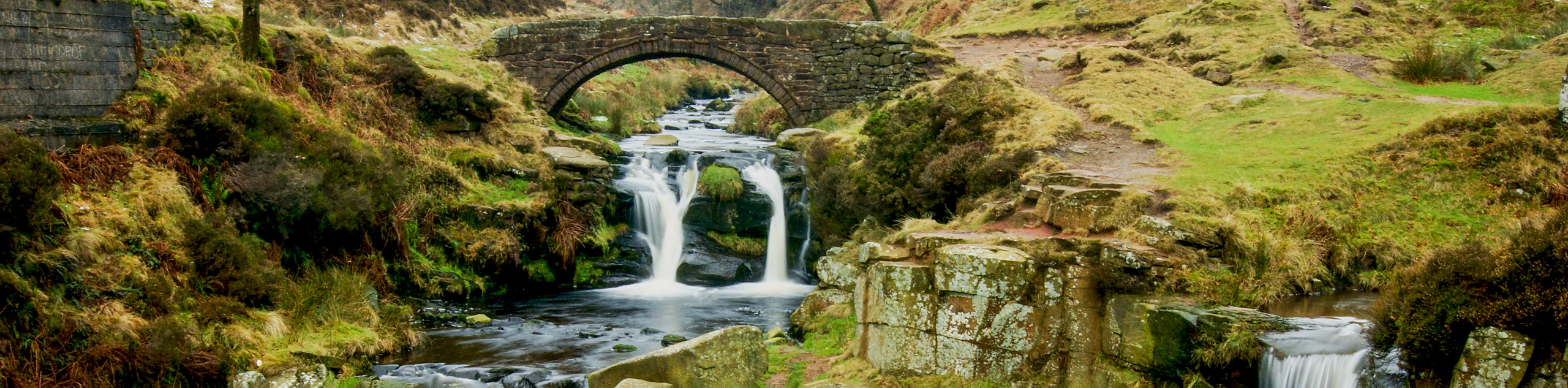
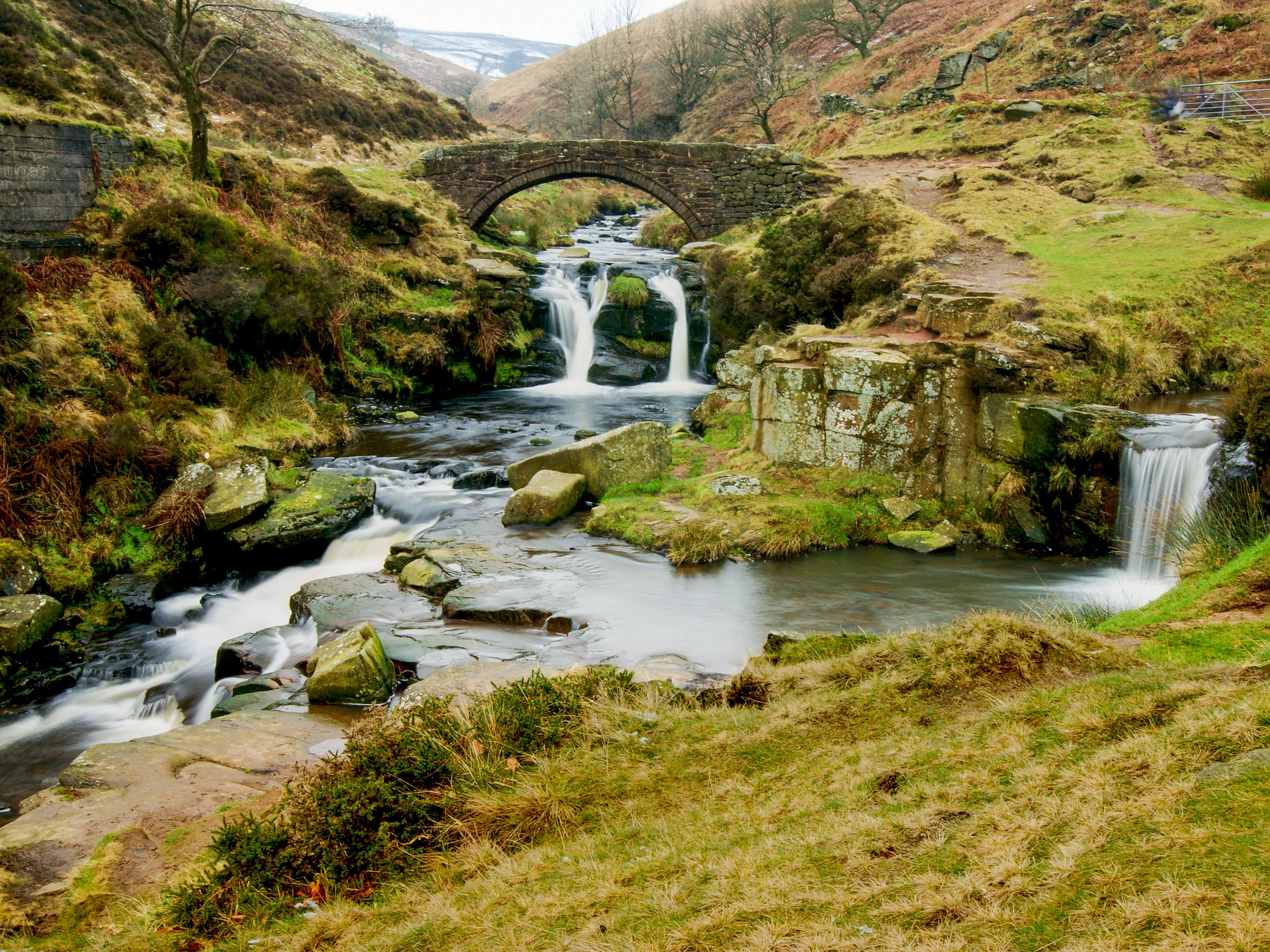
Make your way across and pick up the track to the left to continue along a route that runs parallel to the stream. Shortly after passing through a gate, you will need to bear left at a fork in the trail and keep straight for 0.19mi, where you will come to another junction at the water’s edge. Take the path to the right, following it along the edge of the stream until you pass through a gate and arrive at the scenic location of Three Shires Head. At this point, the boundaries of Cheshire, Derbyshire, and Staffordshire all converge on a picturesque location at the edge of the River Dane that features a charming 18th Century packhorse bridge and a cascading waterfall.
After exploring this scenic location and catching a bit of rest, take the trail leading south and make your way over a bridge at the edge of the wood to set out for the remainder of the circular walk. The trail here follows closely along the edge of the River Dane for 0.15mi, before keeping left through a gate and continuing along the foot of Turn Edge. Keep left along the base of the hill for 0.64mi until you meet back up with the road. From here, follow it for 0.28mi and turn right, heading down the lane and past the cottage until you arrive at a gate.
Head through the gate and keep left along the trail, passing through another gate before you arrive at a bridge crossing. Make your way over and continue straight through the junction. Follow this path for 0.28mi, crossing over a stile and passing through a gate before meeting up with a laneway near Axe Edge Green Farm. Pass through the gate and go right along the road, followed by a left in 234ft that will take you through another gate. Cross the small field and make your way over a stile to arrive at another gate at the edge of the road. Head through it and follow the road to the left for 0.26mi to arrive back at the starting point of the Dovehead and Three Shires Head Circular Walk. From here, you can either spend some time exploring the village, or pop into Britain’s highest village pub for a bite to eat before heading home.
Trail Highlights
Three Shires Head
This picturesque location along the River Dane marks the spot where Cheshire, Derbyshire, and Staffordshire all converge. Featuring a charming 18th Century packhorse bridge, cascading waterfalls, and the breathtaking scenery of Axe Head Moor in the backdrop; there is no better place to set up for a tranquil picnic lunch in the English countryside.
Frequently Asked Questions
Does this walk have any toilet facilities?
There are no toilets along this trail, so plan ahead before setting out on your walk.
Is there a carpark at the trailhead?
This walk sets out from the village of Flash, right in front of The New Inn. You will need to find parking in the village.
Other amazing walks in Peak District National Park
Check out our guides to Kinder Scout, Mam Tor, Stanage Edge, Dovedale, and Padley Gorge. Or see all of our Peak District walks on 10Adventures.
Insider Hints
The starting point of this walk, The New Inn, is Britain’s highest village pub at 1518ft. Stop in for a quick pint or a bite to eat after your walk.
As there are sheep free-roaming along this walk, make sure to keep your dogs on-leash to avoid any interactions.
Wear proper walking boots, as parts of this walk can be boggy.
Similar hikes to the Dovehead and Three Shires Head Circular Walk hike

Valehouse Reservoir Circular
The Valehouse Reservoir Circular is a 3.1mi lollipop trail near Glossop that travels around the edge of the…

Three Edges Walk
The Three Edges Walk is a challenging circuit in Derbyshire that will take you along three escarpments that offer some…

Edale Rocky Ridges Walk
The Edale Rocky Ridges Walk is just that - an adventurous walk along a rugged ridgeline. While out on the…
Comments