Macclesfield Forest and Cheshire Matterhorn Walk
View Photos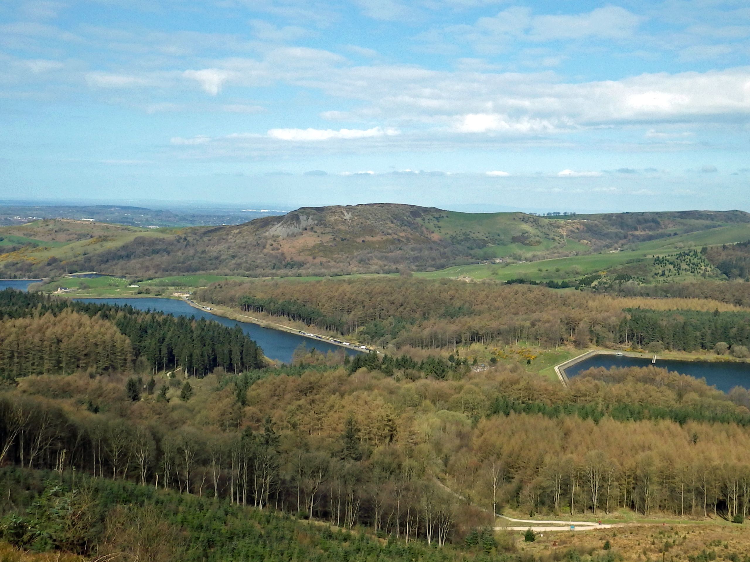
Macclesfield Forest and Cheshire Matterhorn Walk
Difficulty Rating:
The Macclesfield Forest and Cheshire Matterhorn Walk is a fun but challenging walk that will take you through a nice variety of terrain and elevation gain for some scenic views from the summit of Shutlingsloe. Along the trail, walkers will make their way through beautiful woodland terrain, across open meadows, and up rugged hills to take in some of the best views of the beautiful Cheshire countryside. Be prepared for a lot of ups and downs through the hilly terrain along this undulating trail.
Getting there
To reach the trailhead for the Macclesfield Forest and Cheshire Matterhorn Walk from Macclesfield, drive southwest along Buxton Old Road for 1.2mi, where it will veer left and become Buxton Road/A537. In 0.8mi, turn right to enter the car park.

About
| When to do | March-October |
| Backcountry Campsites | No |
| Pets allowed | Yes |
| Family friendly | Older Children only |
| Route Signage | Average |
| Crowd Levels | Moderate |
| Route Type | Circuit |
Macclesfield Forest and Cheshire Matterhorn Walk
Elevation Graph
Weather
Macclesfield Forest and Cheshire Matterhorn Walk Description
Completing the Macclesfield Forest and Cheshire Matterhorn Walk isn’t a terribly difficult feat; however, there are a number of different terrain types that you will have to traverse and the route does feature quite a few ascents and descents through the hilly terrain. Make sure that you are seasoned enough as a walker to handle the physically demanding parts of this route, or you can always adjust your walk to exclude some of the more difficult bits. For those accessing the trailhead by car, paid parking is available at the car park near Tegg’s Nose and will cost about £3 for 3+ hours.
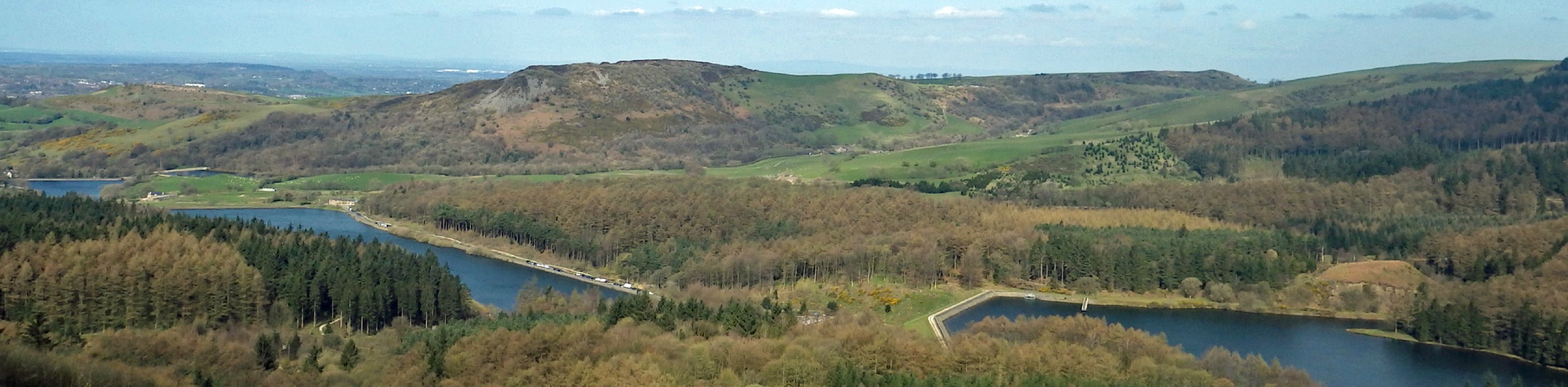
Although there are some difficult stretches along this walk, the views of the picturesque Cheshire countryside more than make up for any trouble that you might have. While out on the trail, walkers will be able to take in the beauty of the Macclesfield Forest, where they can spot local wildlife, such as red deer and herons before heading up to Shutlingsloe (aka Cheshire’s Matterhorn) for some amazing views of the surrounding green hills from atop a unique and prominent peak. This route has a lot to offer if you are willing to stick out the rough bits, so pack your gear and get ready for a fun day on the trails within Peak District National Park
Setting out from the car park at the Tegg’s Nose Country Park, make your way to the northwest toward Buxton Old Road, where you will find a path to the left that runs parallel to the road. Follow this to the southwest to pass through a kissing gate and set out on a course for the rugged ridge of Tegg’s Nose. After 0.26mi, head through a gate and take an immediate left, where you will be met by a flight of steps, follow these uphill to gain some elevation on your approach to the summit of the hill.
Once you have met back up with the trail, follow it for 0.3mi to work your way along the summit of Tegg’s Nose, where you will experience some amazing views of the surrounding landscape and pass by remnants of the old mining operations that once took place here. Reaching a junction where the trail branches off to the left, take that path and follow it for 0.1mi to arrive at another junction with a gate on the left. Turn left here and pass through the gate to begin your descent towards the Tegg’s Nose Reservoir.
Keep straight through the junctions as you descend the hill and you will eventually enter the cover of the forest, where you will pass through a series of kissing gates. Upon reaching the junction next to the carpark at the reservoir, go right and follow the dam wall for 385ft, where you will spot a bridge on your left. Cross over the bridge and turn right to make your way through a gate before walking along the dam wall of the Bottoms Reservoir. Follow this path as it skirts along the south side of the water towards the Leather’s Smithy pub. Once there, you can pop in for some refreshments or continue on your walk by turning right onto Standing Stone Road and picking the trail up on the left side as it runs parallel to the road.
Enjoy the scenic views of across the water of the Ridgegate Reservoir, with the dense cove of the Macclesfield Forest on your left. Roughly 0.5mi from the pub, you will come to a fork in the road. Head to the left but cross over the road to enter into the forest along a trail that will lead you through the picnic area. Shortly after the picnic area, pass straight through a junction and turn right at the next one to chart a course through the forest toward Shutlingsloe.
Continue straight along the trail for 0.6mi and enjoy the breathtaking atmosphere of the forest, passing through the kissing gate and keeping left along the Forest Bridleway to continue on for another 0.1mi, before heading right at the fork. At the junction shortly after, turn right and pass through another kissing gate, keeping to the right as you walk across the moor for 0.4mi with the distinctive peak of Shutlingsloe directly in front. Pass through yet another kissing gate to continue across the moor, where you will come to the foot of the hill. Cross the stile to begin the steep climb up to the summit of the hill, where you will have a commanding view overlooking the beautiful landscape of Cheshire County and the rugged terrain of the Peak District.
From the summit, head south along the trail to descend the hill, arriving at a junction in 0.3mi. Keep right and cross over the stile, continuing on for 0.1mi to cross over another stile. After another 0.2mi, make a sharp left turn to head north on a route parallel to Clough Brook. Crossing a distance of 0.5mi, you will pass over three stiles and the trail will meet up with the road, which you will need to follow until you arrive at Dinger’s Hollow Farm.
Passing by the farm on your left, you will find a small gate. Pass through the gate and continue along the trail as it leads northwest towards Tegg’s Nose off in the distance. After 0.3mi, cross over the road and continue on for another 0.3mi to meet up with the road. Follow it to the right and turn left at the first cross street to eventually pass by the St. Stephen’s Forest Chapel on your right. Continue northwest along Old Charity Lane, keeping left at a series of two forks to pass through a small gate and enter into the forest in a westward direction.
Keeping on for 0.6mi through the calm forest terrain, cross over the stile and pass straight through the intersection in the trail, followed by a left turn at the next fork to arrive at another gate. Pass through the gate and follow along Hacked Way Lane for 0.6mi, turning right along the road and left at the trail junction to begin the steep ascent back up the ridge. Pass through the gate to return to the car park where you began the Macclesfield Forest and Cheshire Matterhorn Walk. After wrapping up your walk, spend some time enjoying the amazing views from atop the hill and spread out for a nice picnic before heading home.
Trail Highlights
Tegg’s Nose
Located just east of the town of Macclesfield, Tegg’s Nose is a short ridge with a high point of 1247ft and offers a nice view of the Macclesfield Forest and the surrounding Cheshire landscape. Mined for gritstone from the 16th to 20th century, the area surrounding Tegg’s Nose is thought to have been inhabited since the Bronze Age became a part of the Royal Forest of Macclesfield hunting reserve after the Norman Conquest.
Macclesfield Forest
The Macclesfield Forest is a remnant of what was at one time the Royal Forest of Macclesfield, an ancient hunting ground that once covered vast swaths of terrain around the town of Macclesfield in Cheshire. In an effort to preserve this historic landscape, the forest is now part of a nature reserve that is largely made up of conifer trees. In addition to the beautiful forest, the area also features a small population of red deer, as well as a heronry.
Shutlingsloe
Also known as the Cheshire Matterhorn due to its resemblance to the famous swiss landmark, this small 1660ft peak is the third highest in the county and dominates the Cheshire landscape, offering a commanding view over the rolling green countryside.
Other amazing walks in Peak District National Park
Check out our guides to Kinder Scout, Mam Tor, Stanage Edge, Dovedale, and Padley Gorge. Or see all of our Peak District walks on 10Adventures.
Insider Hints
This route features steep sections of trail that can be challenging for unseasoned walkers.
Pop into Leather’s Smithy for a quick pint or mid-walk meal.
Make sure to keep your dogs on-leash, as there are free-roam sheep in certain areas along this trail.
Parking at Tegg’s Nose costs about £3 for 3+ hours.
Similar hikes to the Macclesfield Forest and Cheshire Matterhorn Walk hike

Valehouse Reservoir Circular
The Valehouse Reservoir Circular is a 3.1mi lollipop trail near Glossop that travels around the edge of the…

Three Edges Walk
The Three Edges Walk is a challenging circuit in Derbyshire that will take you along three escarpments that offer some…

Edale Rocky Ridges Walk
The Edale Rocky Ridges Walk is just that - an adventurous walk along a rugged ridgeline. While out on the…
Comments