Ladybower Reservoir Circular Walk
View Photos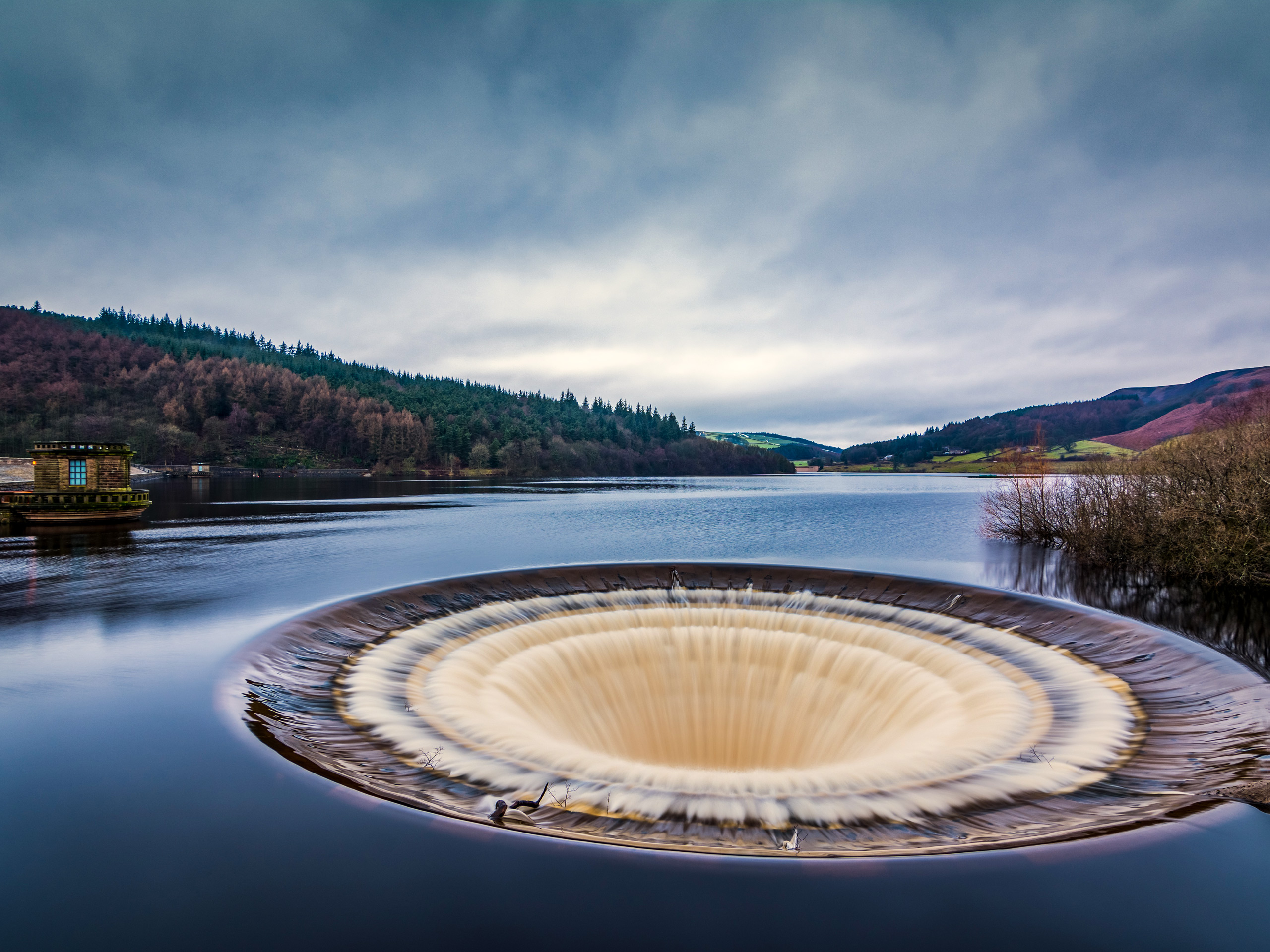
Ladybower Reservoir Circular Walk
Difficulty Rating:
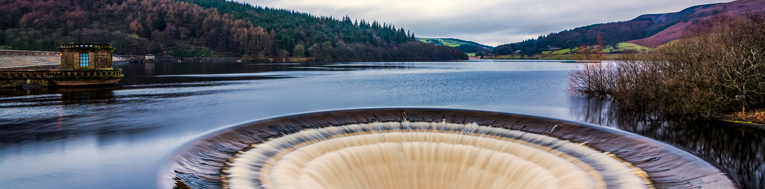
The Ladybower Reservoir Circular Walk is a fantastic long-distance walking route in the Peak District that will see you out for the day, exploring the rolling green hills of the English countryside. While out on the walk, you will have some nice views overlooking the Ladybower Reservoir and the beautifully engineered Ashopton Viaduct. This is a 16.8mi walk, so make sure to set out with the proper gear, as well as enough water and snacks to stay fueled along the trail.
Getting there
To reach the car park for the Ladybower Reservoir Circular Walk from Hope Valley, drive north on Station Road for 2.7mi and turn right onto the A57. In 0.5mi, you will find the car park on the right across from the Ladybower Inn.

About
| When to do | March-November |
| Backcountry Campsites | No |
| Pets allowed | Yes - On Leash |
| Family friendly | Older Children only |
| Route Signage | Average |
| Crowd Levels | Moderate |
| Route Type | Circuit |
Ladybower Reservoir Circular Walk
Elevation Graph
Weather
Ladybower Reservoir Circular Walk Description
While the Ladybower Reservoir Circular Walk features a fair bit of elevation gain, this is largely spread throughout the route and there are really only a few bigger hills that walkers might deem as being steep. The real obstacle on this walk is the overall distance, which at 16.6mi, is a bit longer than most routes in the area. Make sure to plan out your journey and bring any gear/supplies that you might need while out on the walk.
For those that are able to complete this walk in its entirety, you will feel a real sense of accomplishment at having completed such a long route. As a bonus, this scenic trail is filled with some spectacular views that stretch out across the undulating landscape of the Peak District and include the calm waters of the Ladybower Reservoir that is spanned by the beautifully engineered Ashopton Viaduct. If you are up for a long-distance challenge, consider making the Ladybower Reservoir Circular Walk your next big adventure.
Setting out from the car park opposite the Ladybower Inn, head west along the trail that runs parallel to the road and follow it until you meet up with the Ladybower Viaduct. Turn left here and make your way across the wonderfully constructed bridge, taking some time to appreciate the views that stretch out across the calm waters of the reservoir. Once you are across, continue along the road for 0.5mi and pick up the trail branching off to the right. Turn right and pass through a gate to make your way across the dam wall of the Ladybower Reservoir Dam, once again enjoying some scenic views across the water with the rolling green hills in the backdrop.
Reaching the other side of the dam wall, head left and continue along the track for 0.3mi to pass through a gate and eventually arrive at the edge of the road. Follow this south for a short distance and pick up the trail on the right, following it to pass through a series of gates. Turn left at the junction and follow the trail for the next 0.5mi, where you will meet up with Carr Lane. Turn right onto the road, following it for the next 0.4mi until you come to a junction with Thornhill Lane. Follow this to the right and keep straight for the next 1.2mi, as you head through the villages of Thornhill and Aston in a westward direction.
Turn right onto Free Range Lane and follow it for the next 0.2mi until you reach Edge Farm. Turn left here onto Ruin Edge Lane and keep straight along it for 1.2mi, passing by a stretch of wood on your left and making your way through several gates as you climb uphill through the scenic farmland along the slopes of Win Hill. When you have reached the junction in the trail, head left and continue on for 0.6mi to make your way over Wooler Knoll. Take the left path at the fork, followed by a right turn at the next junction to continue on for 0.5mi and arrive at a gate next to Hope Cross.
Pass through the gate and take the path to the right at the next intersection, following it downhill to eventually cross over the flowing waters of the River Ashop at Haggwater Bridge. From the bridge crossing, continue along the path to the north until you meet up with the A57 and turn left to follow along the road. After 0.8mi, turn right onto the lane and follow it past Rowlee Farm. From here, keep straight for the next 1.0mi to pass between several beautiful forests and arrive at the Lockerbrook Farm Outdoor Centre.
Continue along the path for 1.1mi, as you make your way along the Lockerbrook Heights and enjoy some scenic views of the surrounding woodland terrain and nearby water of the reservoir. Once you have met up with the road, follow it to the right on a route that will take you along the edge of the Derwent Reservoir. Enjoy the views across the water for the next 1.2mi, as you continue south along the road and pass a memorial to the Dambusters of 617 Squadron, a celebrated unit from the Second World War. When you have come to the roundabout, head left along the first exit and follow it for 0.2mi to cross a bridge and pick up the trail on the right.
Follow this trail and keep left until you arrive at a junction with Derwent Lane. Go right and follow the road along the edge of the water for the next 1.2mi, enjoying the scenic views until you arrive at a junction with two gated paths. Take the path to the left and pass through the gate, following the trail as it climbs uphill towards several buildings. Pass through the series of gates and cross over Grindle Clough, keeping right along the trail for the next 1.3mi as you climb uphill along the moor and summit Whinstone Lee Tor.
Arriving at an intersection with several routes branching off in all directions, the second path on the right will lead you to a scenic lookout with a commanding view over the surrounding landscape, including the reservoir far below. From the lookout trail, take the path directly opposite (second to the right) to continue along the rugged, yet beautiful terrain of the moor in an eastward direction.
When you reach the fork in the trail along Highshaw Clough, keep right and follow the path downhill for the next 0.9mi to pass through the beautiful woodland terrain of the Priddock and Ladybower woods and arrive back at the starting point of the walk. Having completed the lengthy Ladybower Reservoir Circular Walk, head into the nearby Ladybower Inn for some post-walk refreshments, or cross the road to return to the car park.
Other amazing walks in Peak District National Park
Check out our guides to Kinder Scout, Mam Tor, Stanage Edge, Dovedale, and Padley Gorge. Or see all of our Peak District walks on 10Adventures.
Insider Hints
This is a fairly long walk, so make sure to wear sturdy and comfortable walking footwear.
Parts of the route follow along roadways. Keep an eye out for passing traffic.
Pop into the Ladybower Inn for a quick pint to celebrate completing the 16.8mi journey.
Similar hikes to the Ladybower Reservoir Circular Walk hike

Valehouse Reservoir Circular
The Valehouse Reservoir Circular is a 3.1mi lollipop trail near Glossop that travels around the edge of the…

Three Edges Walk
The Three Edges Walk is a challenging circuit in Derbyshire that will take you along three escarpments that offer some…

Edale Rocky Ridges Walk
The Edale Rocky Ridges Walk is just that - an adventurous walk along a rugged ridgeline. While out on the…
Comments