Dale Dike Reservoir Walk
View Photos
Dale Dike Reservoir Walk
Difficulty Rating:
The walk around the Dale Dike Reservoir is a fairly quick adventure in Peak District National Park that will take you along the forested edge of a reservoir for some charming views across the water. The route largely features a beautiful woodland setting, although you will have a few chances to view the surrounding landscape as you meander along the water’s edge. Avoid this walk after any prolonged rainfall, as the trail will be extremely muddy.
Getting there
To reach the trailhead for the Dale Dike Reservoir Walk from Low Bradfield, drive west along Mill Lee Road and turn right onto Windy Bank, following it for 1.3mi. Turn left onto Mortimer Road and continue on for 1.6mi to find the trailhead on the left.

About
| When to do | March-November |
| Backcountry Campsites | No |
| Pets allowed | Yes - On Leash |
| Family friendly | Older Children only |
| Route Signage | Average |
| Crowd Levels | Moderate |
| Route Type | Lollipop |
Dale Dike Reservoir Walk
Elevation Graph
Weather
Dale Dike Reservoir Walk Description
While the Dale Dike Reservoir Walk in Peak District NP is a relatively laid back and easy journey, it is not without its hazards. During the winter months and after periods of prolonged rainfall, vast stretches of the trail will often become blanketed in a thick covering of mud. It’s best to avoid the trail during these times and save the route for a dry, sunny day when you can take advantage of the shade offered by the woodland setting.
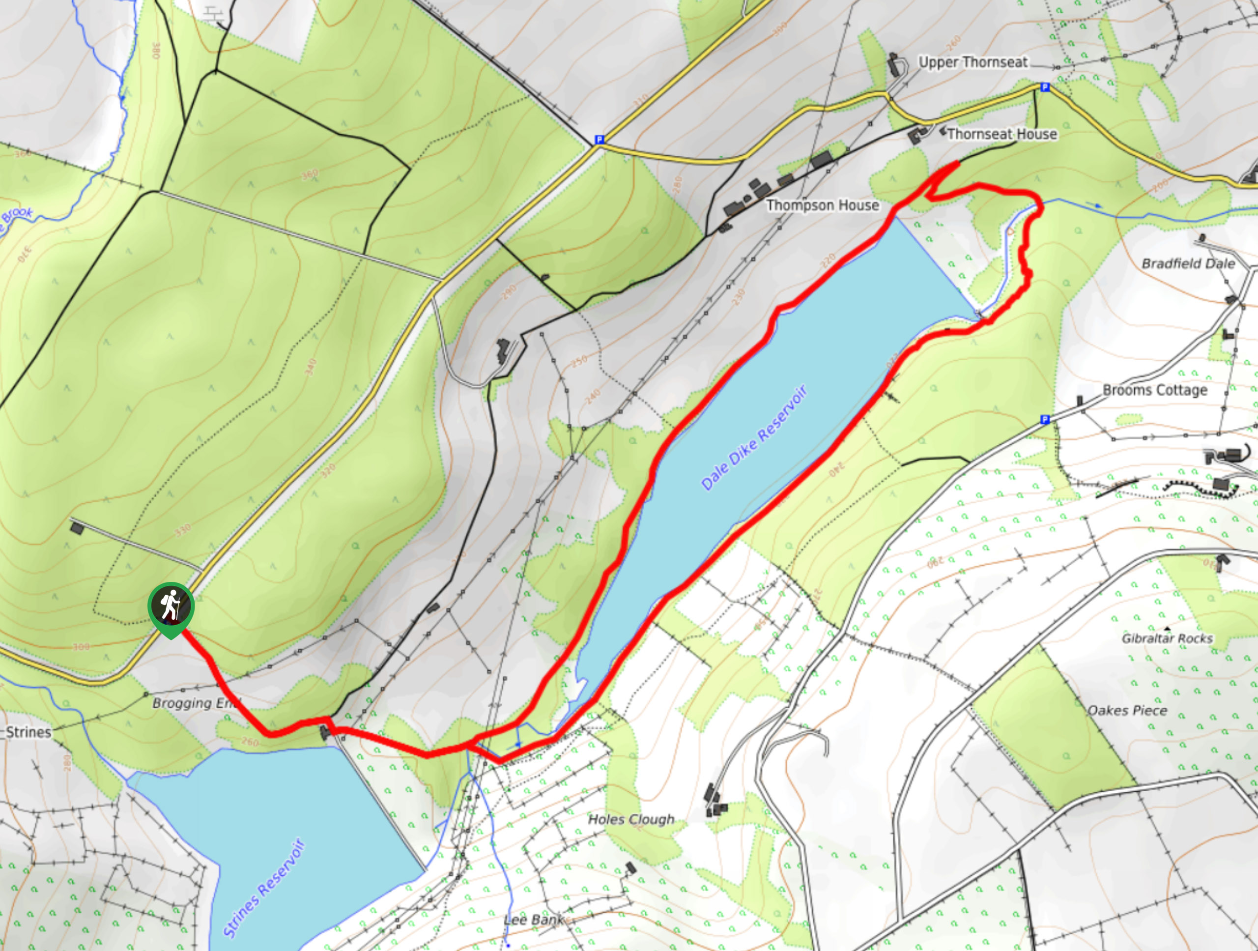
Setting out from the trailhead, make your way to the southeast to descend the hillside and arrive at the edge of Holes Wood. As you walk through the forest, take some time to appreciate the tranquil atmosphere as you make your way closer to the edge of the Dale Dike Reservoir. After crossing a stream, keep left at the fork to make your way around the north side of the reservoir, taking in the intermittent views across the water that become available through the tree cover.
As you come to the dam, continue straight along the track to meander through the forest and cross over Dale Dike, where the trail will turn to the southwest to once again follow closely along the edge of the reservoir. The forest along this stretch is much thicker, and on a hot summer day, it will provide a good bit of reprieve from the blistering sun. After passing through Andrew Wood, make your way over the same stream and continue along the trail to the northwest, eventually arriving back at the trailhead where you began to Dale Dike Reservoir Walk.
Other amazing walks in Peak District National Park
Check out our guides to Kinder Scout, Mam Tor, Stanage Edge, Dovedale, and Padley Gorge. Or see all of our Peak District walks on 10Adventures.
Similar hikes to the Dale Dike Reservoir Walk hike

Valehouse Reservoir Circular
The Valehouse Reservoir Circular is a 3.1mi lollipop trail near Glossop that travels around the edge of the…

Three Edges Walk
The Three Edges Walk is a challenging circuit in Derbyshire that will take you along three escarpments that offer some…

Edale Rocky Ridges Walk
The Edale Rocky Ridges Walk is just that - an adventurous walk along a rugged ridgeline. While out on the…
Comments