
Wylam and Ovingham Circular Walk
View Photos
Wylam and Ovingham Circular Walk
Difficulty Rating:
The Wylam and Ovingham Circular Walk is a lovely adventure in Northumberland that will expose you to charming villages and scenic riverside settings. While out walking the trail, you will make your way along the banks of the River Tyne, passing through peaceful parks and crossing over the Ovingham Bridge, before making the return along the opposite bank of the river. This is a fantastic walk for those who enjoy spending time by the water.
Getting there
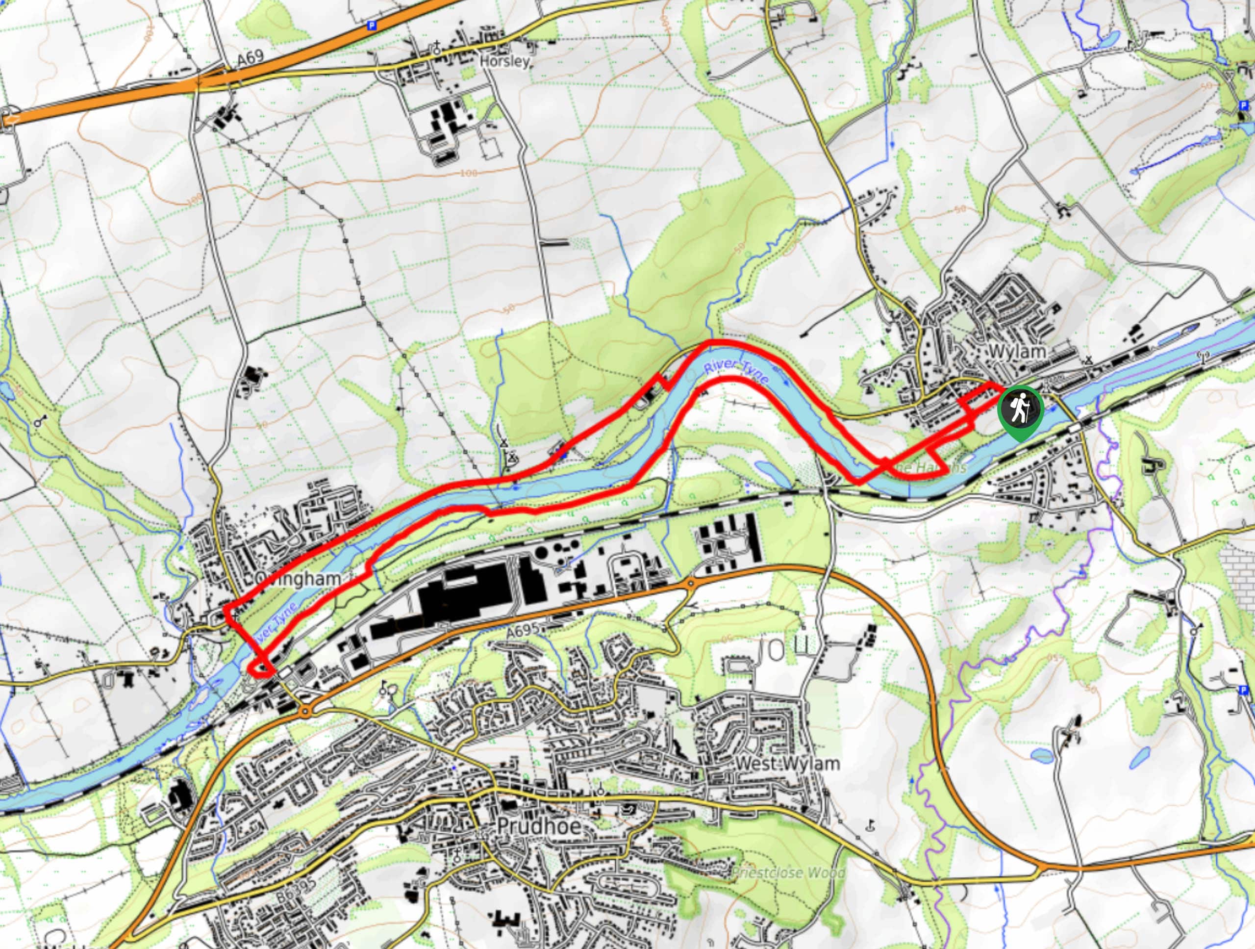
The trailhead for the Wylam and Ovingham Circular Walk can be found next to the Fox & Hounds pub in Wylam.

About
| Backcountry Campground | No |
| When to do | Year-Round |
| Pets allowed | Yes - On Leash |
| Family friendly | Yes |
| Route Signage | Average |
| Crowd Levels | Moderate |
| Route Type | Circuit |
Wylam and Ovingham Circular Walk
Elevation Graph
Weather
Wylam and Ovingham Circular Walk Description
Although the terrain along the Wylam and Ovingham Circular Walk isn’t challenging, you should still wear comfortable walking shoes that will help you to better traverse the 5.3mi. Be sure to keep your dogs on a lead at all times, as there will likely be a number of other walkers utilizing the trail.
If you enjoy meandering along quiet pathways through peaceful riverside settings, then the Wylam and Ovingham Circular Walk will be a great route to get out for some exercise. Although some p[ortions of the walk do pass through urban areas, the majority of the trail is lined with beautiful trees, making this a fun nature excursion that can be undertaken without straying too far from town.
Setting out from the trailhead next to the Fox and Hounds pub, you will head southeast through the trees in order to join up with Cycle Route 72. Turning right, follow the path as it leads southwest across Main Road and through Wylam Jubilee Field.
After passing through a forested area, you will cross over the expanse of the Wylam Railway Bridge and enjoy views over the River Tyne, before picking up the trail on your right immediately after crossing the bridge. From here, you will follow along the winding banks of the River Tyne for the next 1.9mi, enjoying the surrounding woodland scenery and views across the water, before passing underneath Ovingham Bridge.
Shortly after the bridge, you will turn left along a path that will lead you around the Tyne Riverside Cafe to meet up with Station Road. Turning left here, you will make your way across the River Tyne once more, this time utilizing the Ovingham Pedestrian Bridge. Once you are on the opposite bank, follow the road for 80ft, before picking up a path on your right that will connect with The Hill.
Heading north until you reach a junction with Castle View, you will turn right and follow the road for 1.2mi, as it runs parallel to the banks of the River Tyne. Just after passing the pumping station, you will turn right to reach a footpath and follow it left along the river for 0.1mi, before meeting back up with the road. From here, you will turn right onto Ovingham Road and follow it to the southeast for 0.4mi, where you will pick up another footpath on the right.
Continuing alongside the river, you will enter into the tree cover of The Haughs, following the footpath for 0.5mi where it will meet up with Chapel Lane.
Heading to the right, follow Chapel Lane until it meets Woodcroft road, where you will make another right. In 445ft, you will turn right onto Main Road, where you will quickly arrive back at the starting point of the Wylam and Ovingham Circular Walk.
Trail Highlights
Ovingham Bridge
Spanning the River Tyne in Northumberland, Ovingham Bridge is actually a pair of parallel bridges – one pedestrian and the other for vehicles – that connect Ovingham and Prudhoe on opposite banks of the river. The bridge was constructed in 1883 by the Ovingham Bridge Company as a means to replace the ferry that had been previously used to cross the river. The total length of the bridge is 492ft.
Insider Hints
Wear comfortable walking shoes for this adventure.
The Fox & Hounds is a great place near the trailhead for a quick pre/post-walk pint.
Toilet facilities can be found close to the trailhead, at the Wylam Jubilee Field.
Similar hikes to the Wylam and Ovingham Circular Walk hike

Hadrian’s Wall: Steel Rigg to Lanercost
Walking Hadrian’s Wall: Steel Rigg to lanercost is a fantastic - albeit lengthy - adventure that will lead you across…

Hadrian’s Wall: Wallsend to Heddon on the Wall
Hadrian’s Wall: Wallsend to Heddon on the Wall is the first section of the long distance Hadrian’s Wall Path walking…

Scotch Gill Woods Walk
The Scotch Gill Woods Walk is a short and easy-going adventure in Morpeth, Northumberland that will take you through a…
Comments