Sill and Sycamore Gap Walk
View Photos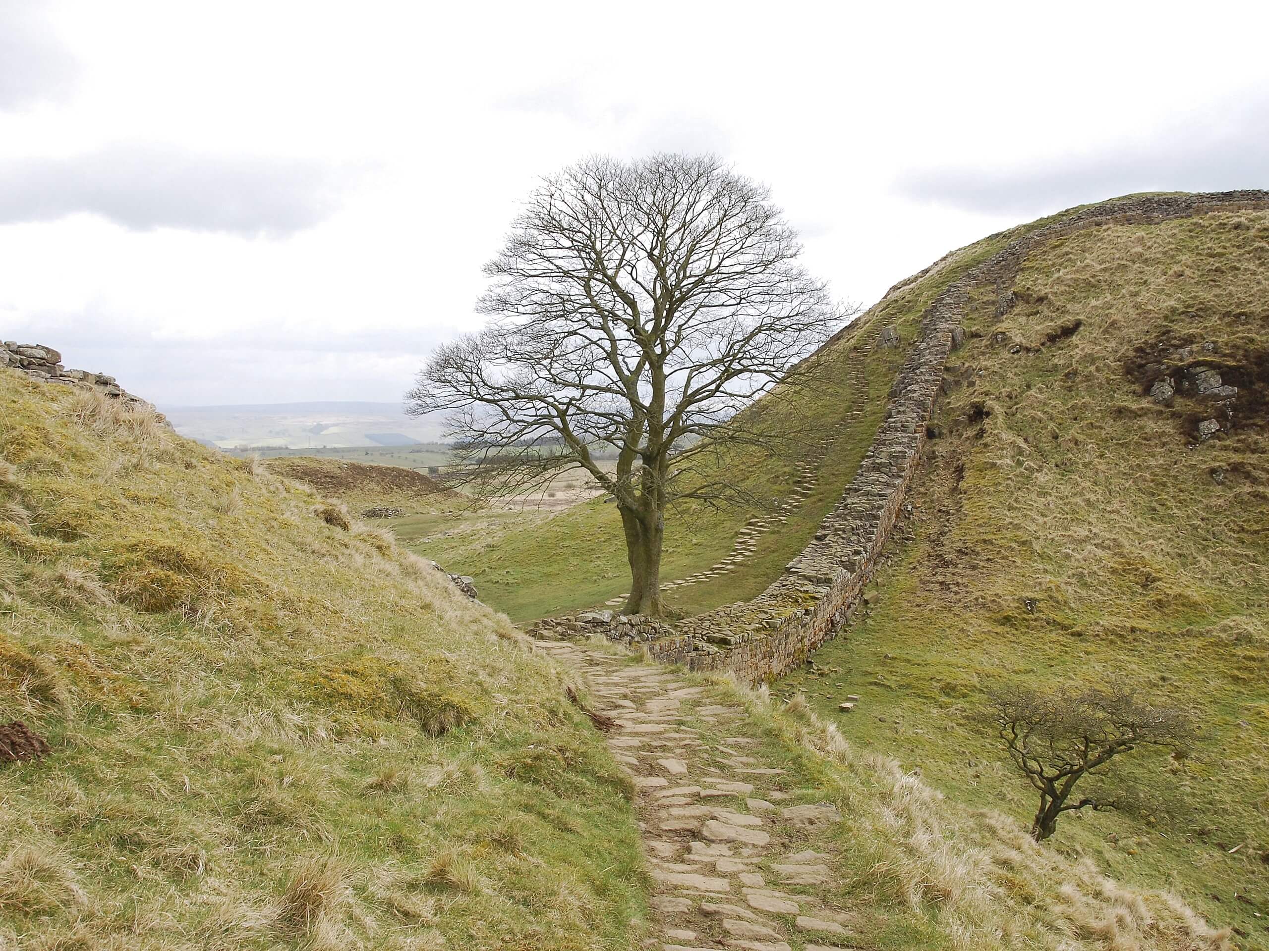
Sill and Sycamore Gap Walk
Difficulty Rating:
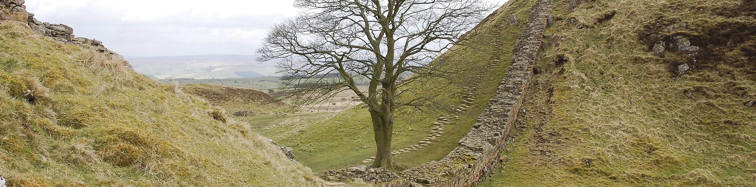
The Sill and Sycamore Gap Walk is a great outdoor excursion in Northumberland that will take you along Hadrian’s Wall to a scenic hillside setting. While out walking the trail, you will traverse the English countryside to reach Sycamore Gap, the most photographed tree in the county, before returning along Hadrian’s Wall and Steel Rigg. This is a fun walk for ancient historians, photographers, and those who simply enjoy views of the countryside.
Getting there
The trailhead for the Sill and Sycamore Gap Walk can be found at the Steel Rigg car park, just north of the village of Once Brewed.

About
| Backcountry Campground | No |
| When to do | Year-Round |
| Pets allowed | Yes - On Leash |
| Family friendly | Yes |
| Route Signage | Average |
| Crowd Levels | High |
| Route Type | Lollipop |
Sill and Sycamore Gap Walk
Elevation Graph
Weather
Sill and Sycamore Gap Walk Description
While the Sill and Sycamore Gap Walk is a fairly short adventure, there are some sections of uphill walking, as well as several stiles and kissing gates. Be sure to wear proper walking shores to safely traverse the terrain. Additionally, this is a very busy walk, so make sure to arrive early in order to secure parking at either the main car park or the overflow lot next to it.
Even though this is a popular walking route, it is certainly for good reason, as the striking views of Sycamore Gap and the rich history of Hadrian’s Wall will always make for a fun day out on the trails. Whether you are planning this walk for the stunning views across the Northumberland landscape, to take in some ancient history, or a mix of both, you will not be disappointed when you experience the majestic scenery.
Setting out from the Steel Rigg car park, head east in order to pick up the footpath and follow it south past the trees and through a gate. After crossing a stretch of field, you will come to a junction in the trail and turn left, passing through another gate to begin climbing up the hillside towards the rocky outcrop known as Steel Rigg.
After reaching a fork in the path, make a sharp right and follow the trail to the southwest, passing through another gate to arrive at a cottage. Keeping left at the cottage, you will follow the path for the next 0.6mi, crossing over one stile in the process before arriving at another junction. Turning left here, you will quickly arrive at the scenic location of Sycamore Gap.
This small saddle in between two hills features a single tree sprouting up from its lowest point, which makes for a striking place to take photos, leading to it being labelled as one of the most photographed trees in the country. In fact, this site is also referred to as Robin Hood’s Tree, as it was used as a filming location for the popular movie Robin Hood: Prince of Thieves.
After taking in the scenic views of Sycamore Gap, you will make your way uphill to the west alongside Hadrian’s Wall to visit Milecastle 39, also known as Castle Nick. The Romans placed these fortifications along the entire length of the wall to serve as outposts in the defence against the Pictish people to the north.
After exploring the ancient site of Milecastle 39, you will continue on to the west for another 0.5mi, passing through a kissing gate to enjoy the sweeping views of the surrounding landscape from atop Steel Rigg. After arriving at another junction, you will take the path on the right and make your way through another kissing gate and over one stile, before following your initial path back to the car park having completed the Sill and Sycamore Gap Walk.
Trail Highlights
Hadrian’s Wall
Constructed during the reign of the Roman emperor Hadrian in the 2nd Century, Hadrian’s Wall is an impressive defensive fortification that spans northern England, from Walsend to Bowness-on-Solway. In addition to defending the province of Britannia from the Picts to the north, it is possible that the gates along the wall served as customs posts. The wall was designated as a UNESCO World Heritage Site in 1987 and there is a long distance walking route (the Hadrian’s Wall Path) that runs parallel to it.
Frequently Asked Questions
How long was Hadrian’s Wall?
Hadrian’s Wall was a defensive fortification that spanned 73.0mi across northern Britain.
How much of Hadrian’s Wall is left?
While it is the largest surviving piece of architecture from Roman Britain, only about 10% of Hadrian’s Wall remains visible today.
Insider Hints
Arrive early to secure parking.
If the main car park is full, there is an overflow lot right next to it.
Wear comfortable walking shoes.
Similar hikes to the Sill and Sycamore Gap Walk hike

Hadrian’s Wall: Steel Rigg to Lanercost
Walking Hadrian’s Wall: Steel Rigg to lanercost is a fantastic - albeit lengthy - adventure that will lead you across…

Hadrian’s Wall: Wallsend to Heddon on the Wall
Hadrian’s Wall: Wallsend to Heddon on the Wall is the first section of the long distance Hadrian’s Wall Path walking…

Scotch Gill Woods Walk
The Scotch Gill Woods Walk is a short and easy-going adventure in Morpeth, Northumberland that will take you through a…
Comments