
Ingram Wether Hill and Ewe Hill Road Walk
View Photos
Ingram Wether Hill and Ewe Hill Road Walk
Difficulty Rating:
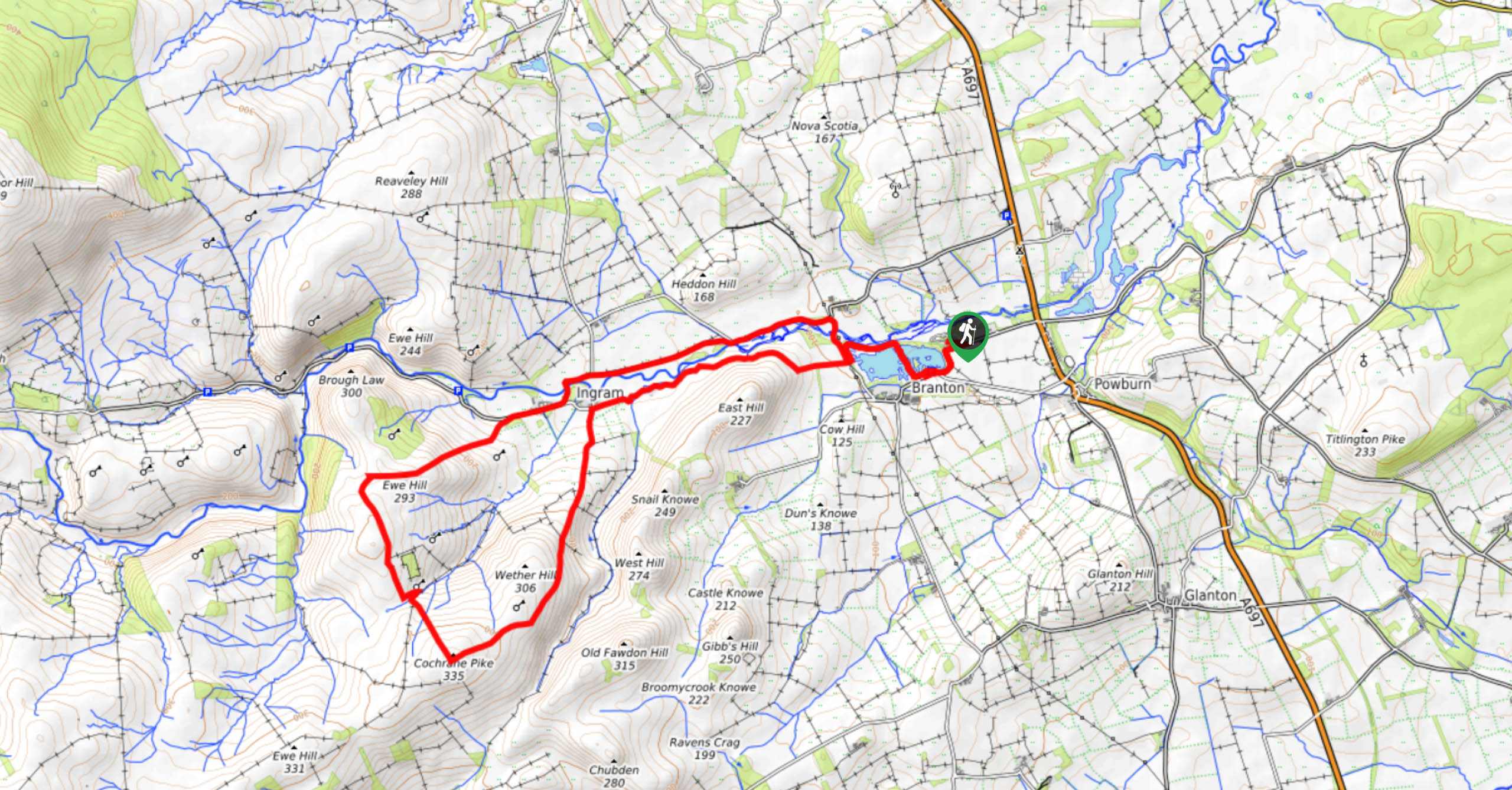
The Ingram Wether Hill and Ewe Hill Road Walk is an excellent Northumberland adventure that features a variety of terrain and scenic views across the landscape. While out walking the trail, you will work your way around the Branton Ponds and along the River Breamish, before traversing the undulating terrain of Wether Hill, Cochrane Pike, and Ewe Hill on the return. Be sure to exercise caution on the return leg of the walk, as it does follow along the road for a good stretch.
Getting there
The trailhead for the Ingram Wether Hill and Ewe Hill Road Walk can be found at the River Breamish Caravan Club Site, just west of Hedgeley Station.

About
| Backcountry Campground | No |
| When to do | Year-Round |
| Pets allowed | Yes - On Leash |
| Family friendly | Older Children only |
| Route Signage | Average |
| Crowd Levels | Moderate |
| Route Type | Lollipop |
Ingram Wether Hill and Ewe Hill Road Walk
Elevation Graph
Weather
Ingram Wether Hill and Ewe Hill Road Walk Description
If you are after a bit of a longer trail through Northumberland that will provide some beautifully scenic views and can still be undertaken by the entire family, then the 16.6km Ingram Wether Hill and Ewe Hill Road Walk will be perfectly suited to your needs.
Setting out from the trailhead, you will initially head east to meet up with the road, before turning right and following it southwest towards the Branton Ponds. Here, you will leave the road behind and pass in between the two bodies of water while enjoying some lovely views of the surrounding landscape. After reaching the banks of the River Breamish, you will follow it to the southwest until you arrive at the Cheviot Holiday Cottages outside of Ingram.
From here, you will head to the south across the open farmland and climb uphill to reach the top of Wether Hill. After taking some time to appreciate the swapping views of the surrounding Northumberland landscape, you will continue on to the southwest to the summit of Cochrane Pike, before heading north to Ewe Hill. From here, the route will descend back into the village of Ingram to meet up with the road, which you will follow to the east in order to arrive back at the trailhead where you started.
Similar hikes to the Ingram Wether Hill and Ewe Hill Road Walk hike

Hadrian’s Wall: Steel Rigg to Lanercost
Walking Hadrian’s Wall: Steel Rigg to lanercost is a fantastic - albeit lengthy - adventure that will lead you across…

Hadrian’s Wall: Wallsend to Heddon on the Wall
Hadrian’s Wall: Wallsend to Heddon on the Wall is the first section of the long distance Hadrian’s Wall Path walking…

Scotch Gill Woods Walk
The Scotch Gill Woods Walk is a short and easy-going adventure in Morpeth, Northumberland that will take you through a…
Comments