
Brandon, Brough Law, and Wether Hill Circular Walk
View Photos
Brandon, Brough Law, and Wether Hill Circular Walk
Difficulty Rating:
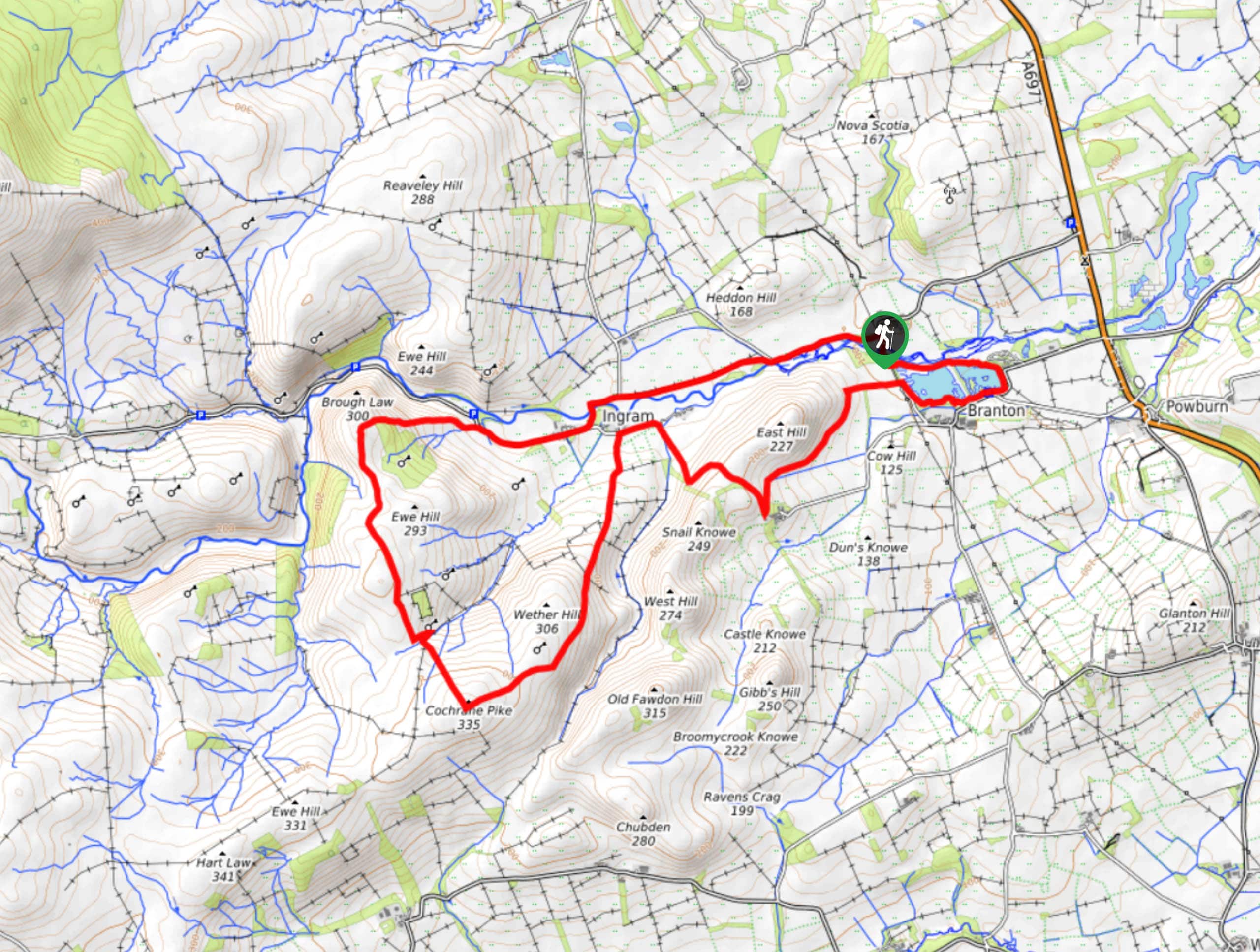
Walking the Brandon, Brough law, and Wether hill Circular Trail is a fantastic outing in Northumberland that will see you traverse several hilltops for scenic views. While out walking the trail, you will follow along the banks of the River Breamish and traverse the tops of Brough Law, Ewe Hill, Cochrane Pike, and Wether Hill, before rounding the Branton Ponds on the return leg. This walk features a fair amount of undulating terrain, so be sure to wear proper walking boots.
Getting there
The trailhead for the Brandon, Brough Law, and Wether Hill Circular Walk can be found at the Brandon Ford Caravan Site, just northwest of Branton along the River Breamish.

About
| Backcountry Campground | No |
| When to do | Year-Round |
| Pets allowed | Yes - On Leash |
| Family friendly | Older Children only |
| Route Signage | Average |
| Crowd Levels | Moderate |
| Route Type | Circuit |
Brandon, Brough Law, and Wether Hill Circular Walk
Elevation Graph
Weather
Brandon, Brough Law, and Wether Hill Circular Walk Description
If you feel like you are in the mood to traverse several undulating hills while experiencing sweeping views overlooking the picturesque countryside of Northumberland, then the Brandon, Brough Law, and Wether Hill Circular Walk is the perfect route to get you outside and exploring nature.
Setting out from the trailhead, you will head west along the road as it runs parallel to the winding River Breamish, passing through the village of Ingram before branching off to the left near the Bulby’s Wood Visitor Centre. Here, you will climb uphill alongside a stream to reach the summit of Brough Law.
After taking in the views, you will follow the trail as it bends to the south, traversing the summits of Ewe Hill, Cochrane Pike, and Wether Hill, before making your way down the slope to the northeast. Here, you will traverse the countryside to the northeast until you reach the edge of Ingram, where you will turn sharply to the southeast to pass between Snail Knowe on your right and East Hill on your left.
Turning northeast along the slopes of East Hill, you will eventually loop around the woodland terrain surrounding the Branton Ponds, taking some time to gaze out across the water before arriving back at the trailhead where you began your journey.
Similar hikes to the Brandon, Brough Law, and Wether Hill Circular Walk hike

Hadrian’s Wall: Steel Rigg to Lanercost
Walking Hadrian’s Wall: Steel Rigg to lanercost is a fantastic - albeit lengthy - adventure that will lead you across…

Hadrian’s Wall: Wallsend to Heddon on the Wall
Hadrian’s Wall: Wallsend to Heddon on the Wall is the first section of the long distance Hadrian’s Wall Path walking…

Scotch Gill Woods Walk
The Scotch Gill Woods Walk is a short and easy-going adventure in Morpeth, Northumberland that will take you through a…
Comments