
Bardon Mill to Haydon Bridge Walk
View Photos
Bardon Mill to Haydon Bridge Walk
Difficulty Rating:
The Bardon Mill to Haydon Bridge Walk is a fantastic adventure in Northumberland that features a variety of terrain and beautifully scenic views. While out walking the trail, you will walk along the River South Tyne and pass through the Allen Banks & Staward Gorge National Trust Site, before traversing the open countryside on the way into Haydon Mill. Walkers should take note that this is a one-way trail; however, the start and end points of the walk are conveniently located at railway stations to allow for easy transportation between the two.
Getting there
The trailhead for the Bardon Mill to Haydon Bridge Walk can be found at the Bardon Mill railway station.

About
| Backcountry Campground | Poplars Riverside Caravan Park |
| When to do | Year-Round |
| Pets allowed | Yes - On Leash |
| Family friendly | Older Children only |
| Route Signage | Average |
| Crowd Levels | Moderate |
| Route Type | One Way |
Bardon Mill to Haydon Bridge Walk
Elevation Graph
Weather
Bardon Mill to Haydon Bridge Walk Description
As the Bardon Mill to Haydon Bridge Walk features a variety of terrain that includes open fields and woodlands, you will want to wear proper walking boots with good support. Additionally, this is a point-to-point walk, so if you aren’t planning on doubling the overall distance of this trail, you should take the train back to the trailhead from the Haydon Bridge railway station. There are also several sections of uphill walking on this route, so be sure to bring plenty of water to stay hydrated.
Even though some of the woodland terrain on this adventure can be a bit rugged, the Bardon Mill to Haydon Bridge Walk is still a fantastic excursion that will reveal the natural beauty of the Northumberland countryside. In addition to the scenic fields, forests, and rivers along the trail, you will also pass by historical ruins, making this intermediate length route perfect for a wide range of outdoor enthusiasts.
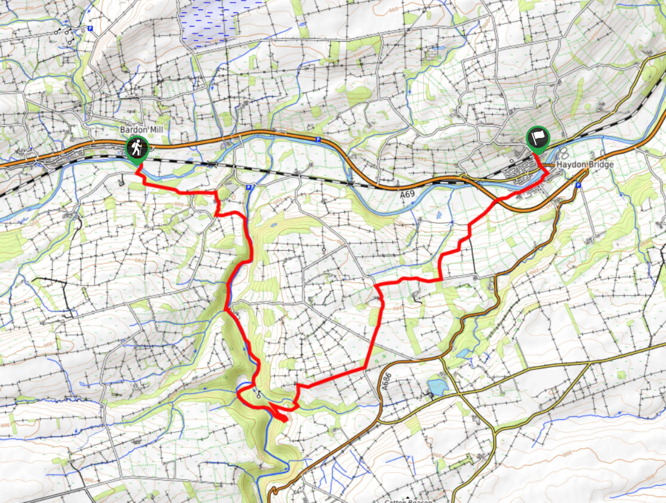
From the starting point of the walk at the Bardon Mill railway station, you will head to the south and cross over the banks of the River South Tyne, turning left along the road and following it southeast for 0.6mi. Here, you will turn left and pass by St Cuthbert’s Church, heading northeast across the fields and forest to arrive at the edge of the road.
Following the road south for 0.26mi, you will make a left onto a footpath and follow it east for 0.3mi, where you will descend into the forests of Allen Banks. After meeting up with the River Allen, follow it south for 0.96mi, where you will cross the bridge over the river to continue south along the opposite bank. After another 1.6mi, you will pass by the Medieval fortification of Staward Peel and begin climbing uphill to arrive at a four-way junction on the edge of the forest.
Turning left, you will continue through the forest for a short distance, before making a sharp right to exit the tree cover. Here, you will cross over Harsondale Burn and climb uphill to the northeast to begin traversing the open countryside that makes up the final leg of the walk. After walking along the quiet country roads to the northeast for 3.4mi, you will come to the edge of the A69.
Continue on to the northeast and into Haydon Bridge, following the road as it runs parallel to the River South Tyne. After turning left and crossing over the river, you will follow Church Street to the northwest until you arrive at the endpoint of the Bardon Mill to Haydon Bridge Walk at the Haydon Bridge railway station.
Trail Highlights
Staward Peel
Although there was likely a shrine existing on site from a much earlier period (possibly dating back to the Roman occupation), the origins of Staward Peel can be dated back to 1316, when a timber pele tower was constructed on site by Anthony de Lucy for use as a garrison. After the lands were annexed by Edward II in 1326, the defensive importance of the site was recognized and a stone castle was constructed. The fortification would change ownership several times over the following centuries until it eventually fell into ruin. The structure was demolished in 1856 and only the ruins of the gatehouse walls now remain.
Insider Hints
As both the start/end points for this walk are located at railway stations, this is the most effective way to complete the return leg of the adventure.
Wear proper walking boots with good support, as there is a variety of terrain on this walk.
Dogs are also permitted to utilize this trail.
Similar hikes to the Bardon Mill to Haydon Bridge Walk hike

Hadrian’s Wall: Steel Rigg to Lanercost
Walking Hadrian’s Wall: Steel Rigg to lanercost is a fantastic - albeit lengthy - adventure that will lead you across…

Hadrian’s Wall: Wallsend to Heddon on the Wall
Hadrian’s Wall: Wallsend to Heddon on the Wall is the first section of the long distance Hadrian’s Wall Path walking…

Scotch Gill Woods Walk
The Scotch Gill Woods Walk is a short and easy-going adventure in Morpeth, Northumberland that will take you through a…
Comments