
Clay Bank and Greenham Bottom Walk
View Photos
Clay Bank and Greenham Bottom Walk
Difficulty Rating:
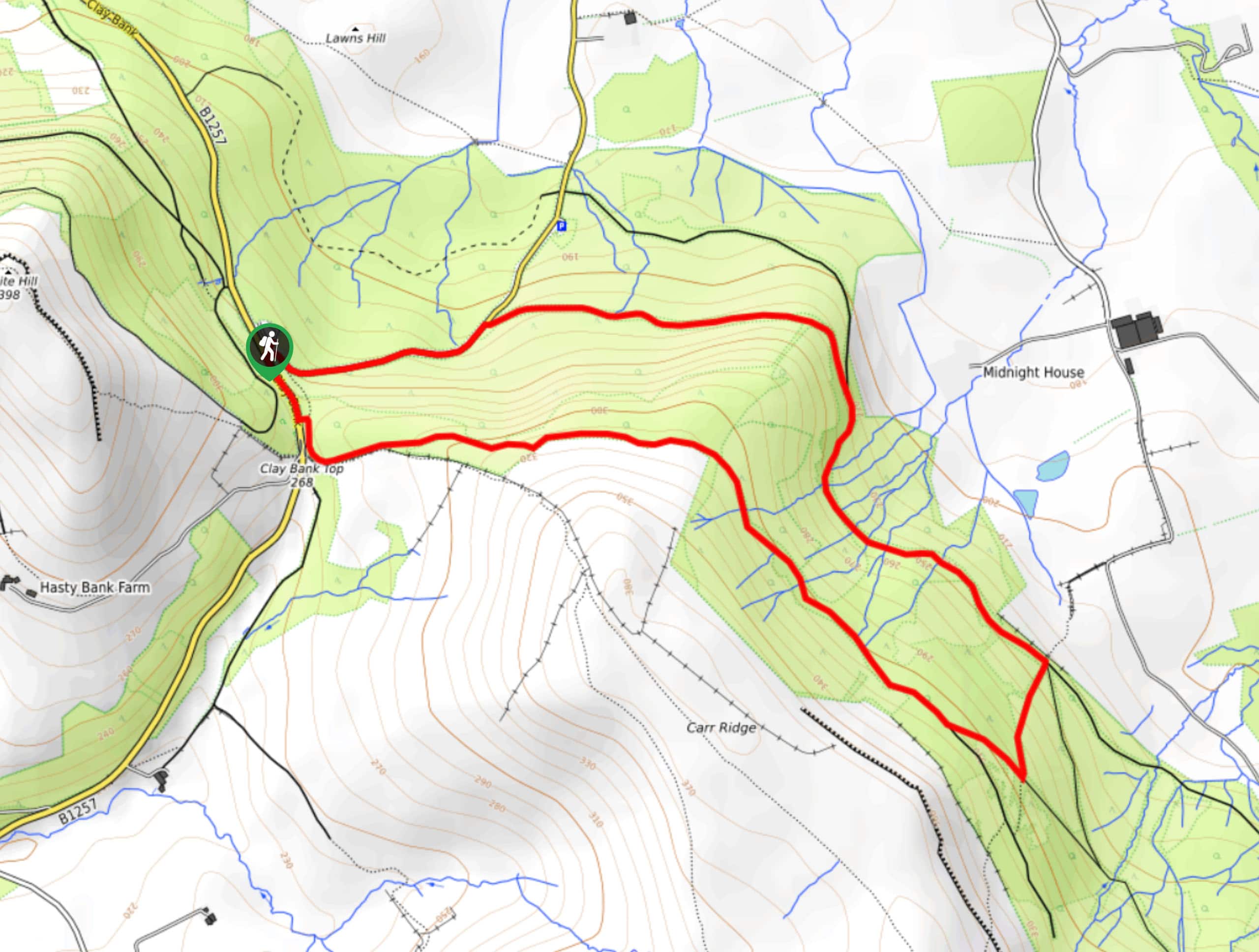
The Clay Bank and Greenham Bottom Walk is a quick and relatively easy journey in the northwest corner of North York Moors National Park that provides amazing views of the surrounding landscape. While out walking the trail, you will pass through forest and open fields along a rugged hillside, before climbing further uphill along the edge of the moor for views of the barren landscape. This walk is fairly short; however, there are a number of climbs and descents throughout that will add a small amount of difficulty.
Getting there
To reach the trailhead for the Clay Bank and Greenham Bottom Walk from Great Broughton, head south on High Street/B1257 for 2.6mi and turn left to enter the car park.

About
| Backcountry Campground | No |
| When to do | Year-Round |
| Pets allowed | Yes - On Leash |
| Family friendly | Yes |
| Route Signage | Average |
| Crowd Levels | Moderate |
| Route Type | Circuit |
Clay Bank and Greenham Bottom Walk
Elevation Graph
Weather
Clay Bank and Greenham Bottom Walk Description
If you are after a fairly short adventure, but one that packs in some fun terrain and scenic views of the North York Moors, then you will certainly want to experience all that the Clay Bank and Greenham Bottom Walk has to offer.
Setting out from the car park, you will head east and make your way through a tranquil stretch of forest, working through Greenhow Bottom around the base of the hill until you break free of the tree cover. From here, you will climb up the hillside towards the edge of the moor, where you will enjoy some amazing views of the surrounding landscape, including Roseberry Topping to the north. From the top of the hill, you will head to the west and descend the hillside to meet up with the road, following it to the north until you arrive back at the car park.
Similar hikes to the Clay Bank and Greenham Bottom Walk hike

Kirkbymoorside and Gillamoor Walk
The Kirkbymoorside and Gillamoor Walk is a great outdoor excursion along the southern edge of North York Moors National Park…

Farndale Railway Walk to Blakey Ridge
The Farndale Railway Walk to Blakey Ridge is a lengthy but easy-going route that will allow you to experience the…

Botton and Blakey Ridge Circular Walk
The Botton and Blakey Ridge Circular Walk is a rugged and beautiful adventure that will allow you to experience the…
Comments