Elsay Lake Trail
View Photos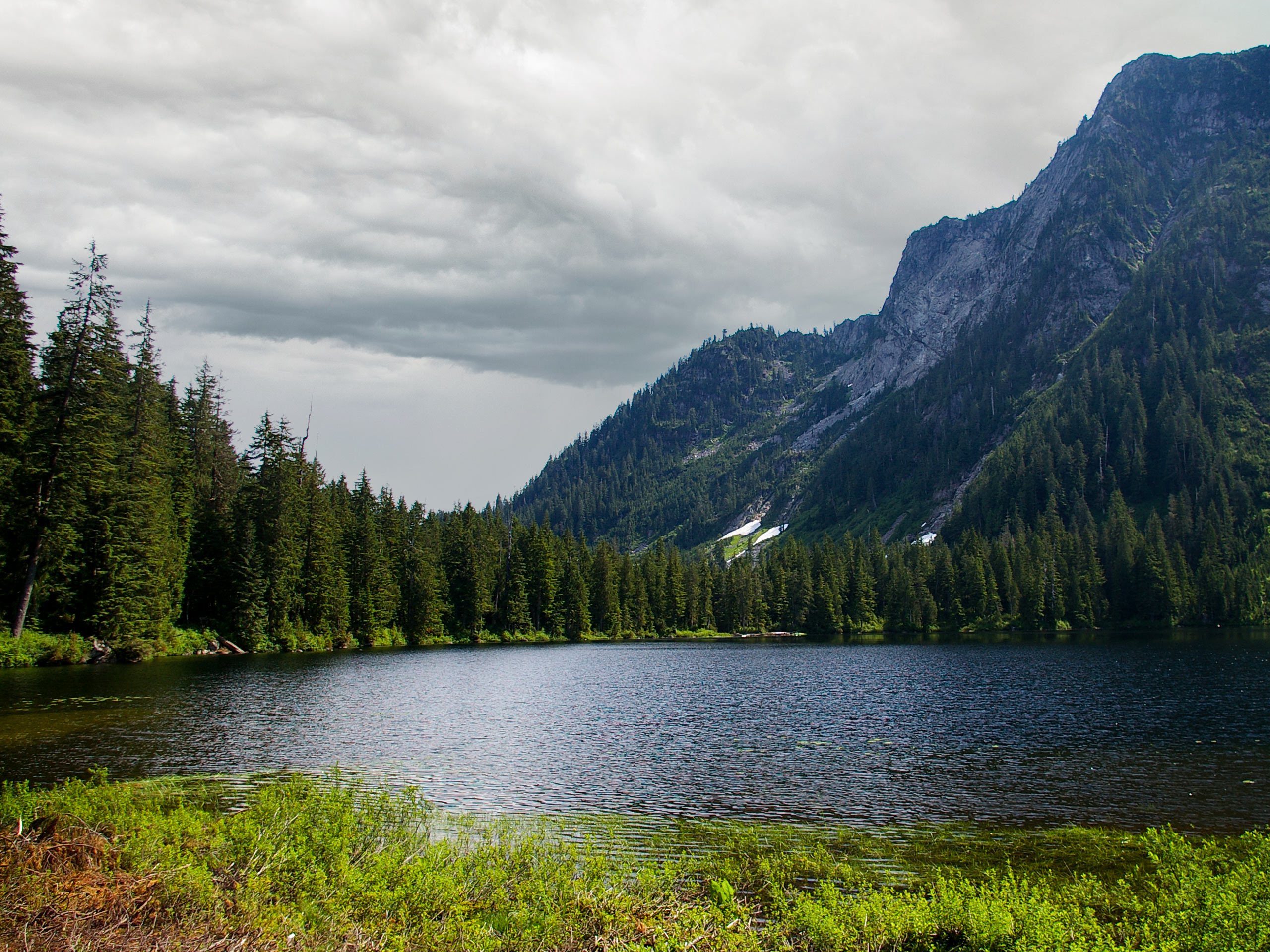
Elsay Lake Trail
Difficulty Rating:
The Elsay Lake Trail is a tough route through the backcountry of Mount Seymour Provincial Park that will leave your legs aching and your feet wet. If hiking uphill over large boulder fields and through wet, bogged down sections of trail is your idea of a fun outing, then this trail is definitely for you. As the trail is quite long and taxing, it’s best to plan on spending the night by the lake, either in the emergency shelter or in a tent.
Getting there
To get to the trailhead for Elsay Lake from Vancouver, drive north along the Trans Canada Highway/BC-1 West and make your way across Ironworkers Memorial Bridge. Take exit 22B for the Mount Seymour Parkway, making a left turn after 4.3mi to get onto Mount Seymour Road. From here, drive north for 8.1mi and you will get to the parking area.

About
| When to do | June-October |
| Backcountry Campsites | Elsay Lake Emergency Shelter |
| Pets allowed | Yes - On Leash |
| Family friendly | No |
| Route Signage | Average |
| Crowd Levels | Low |
| Route Type | Out and back |
Elsay Lake Trail
Elevation Graph
Weather
Elsay Lake Trail Description
The Elsay Lake Trail, much like the neighbouring Mount Elsay Trail, is a difficult hike that should not be undertaken by inexperienced hikers, due to the length of the route and the difficulty of its terrain. This hike has a cumulative elevation gain of 3871ft and crosses over several boulder fields that are difficult to traverse. In addition to this, lower portions of the trail are often wet, muddy, or flooded, making it hard to travel along the route without getting bogged down. All of this adds up to a physically demanding hike that can certainly be done in a day, but is better off split into a two-day trip with an overnight stay by the lake.
This trail may be difficult, but completing it is a rewarding experience that many hikers shy away from. The physical nature of the route is complemented by beautifully scenic views of Elsay Lake, with its mountainous backdrop and heavily wooded surroundings. If you can handle the bugs, an overnight stay in the area offers the peaceful opportunity to enjoy a morning cup of coffee next to the tranquil waters of the lake, providing a few moments of respite before setting back out on the grueling return journey.
The Elsay Lake Trail utilizes the initial stretch of the Mount Seymour Trail, so after leaving the parking lot, make your way north towards the ski run and past the BC parks sign. You will soon reach a three-way junction in the trail. Pass by the Dog Mountain Trail on your left and take the middle trail, as this leads to Mount Seymour.
Follow along this route for 0.6mi, following the trail signs for Mount Seymour and you will eventually reach a dirt road. Turn left and walk along the road as it winds by the base of Mystery Peak ski hill. After approximately 820ft, you will find a trail splitting off to the left of the road. Take this to continue on the route to Mount Seymour, as the trail heads through the trees and past Sugar Bowl Pond on your right. From here, the trail will climb for 1640ft before reaching the rocky outcrop of Brockton Point on your left. This vantage point offers a nice view of the city of Vancouver and the surrounding area.
Keep on the trail for another 2297ft, where you will finally reach a junction with the Elsay Lake Trail to the right. Taking this trail, the terrain will become more rugged and steep as the difficult part of the route is just beginning. From here, the trail skirts around the eastern side of the three peaks of Mount Seymour and descends several hundred meters along the rocky boulder field of the West Staircase. This stretch is difficult on the legs, so make sure to take your time to avoid tiring yourself out, as that is when many hikers fall amongst the loose rocks.
The trail will begin to flatten out a bit as it continues to descend into the valley, passing over several smaller boulder fields and through some wooded areas. As you continue along the forested path, the trail will skirt around the base of Mount Elsay before reaching Elsay Creek. From here, hikers will need to travel along the creek bed on the approach to the lake—a process that will leave many with wet feet during early or late season trips.
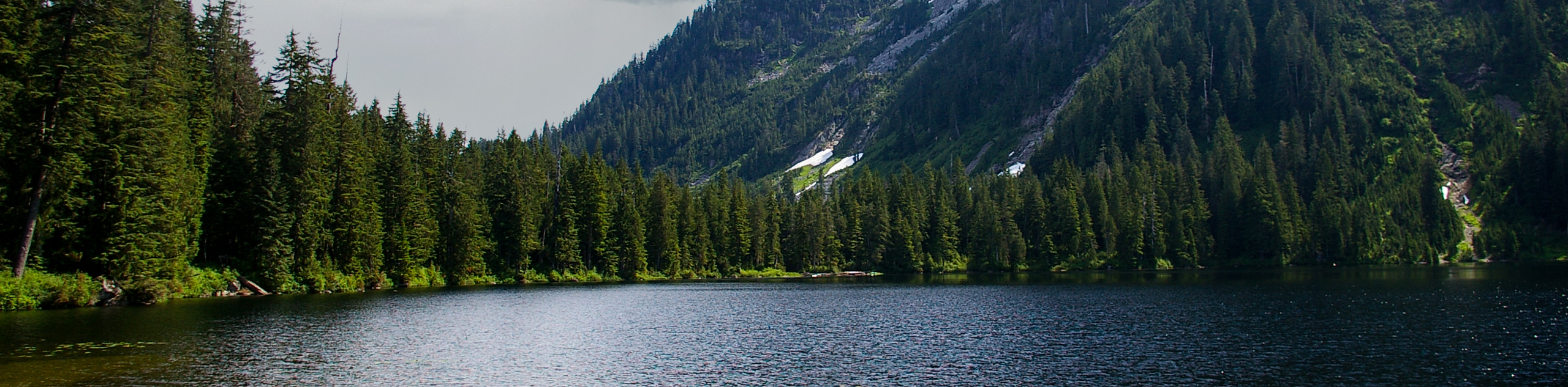
After passing through the dense, moss-covered forest and its wet terrain, hikers will arrive at Elsay Lake, a picturesque body of water nestled snugly in between Mount Elsay and Mount Bishop. These two peaks protect the lake from the elements but also deprive the area of a few hours of sunlight, making setting up camp a priority if you are planning to stay the night.
From here, you can explore the area around the lake, opting to swim or fish in the cool water if you are so inclined. Hikers looking to spend the night can pitch a tent on one of the flat sections along the eastern side of the lake or near the emergency shelter, but as the area around the lake is often wet/flooded, it is best to spend the night in the free accommodation of the shelter. After exploring the area or spending the night, make your way back along the same gruelling trail to return to the parking lot at the Mount Seymour Resort, having completed the Elsay Lake Trail.
Hiking Route Highlights
Elsay Lake
This body of water in Mount Seymour Provincial Park is nestled in the backcountry between Mount Bishop and Mount Elsay, providing the perfect place for a refreshing summertime swim at the end of a long hike. There are a few spots around the lake to set up a tent, but as the area is often wet and boggy it is easier to stay the night in the emergency shelter next to the lake.
Brockton Point
This lookout is the first real vantage point along the trail and offers beautiful views of the city of Vancouver. This rocky outcrop lies just beyond the trail after you pass by Mystery Peak and Sugar Bowl Pond.
Insider Hints
Parking at the trailhead costs $3 and can be paid with cash or card.
The trail signs at the beginning of the hike have valuable information on trail conditions.
Wear proper hiking footwear. Sections of the trail are covered in loose rock and winter gear such as crampons, snowshoes, or skis are useful when the trail is covered in heavy snow and ice
This is a long and difficult trail. Plan to spend the night near the lake by utilizing a campsite or the emergency shelter.
Pay close attention to poorly marked sections of the trail to stay on course.
Bring bug spray, as flies are relentless along the trail.
As with most BC trails, bear spray is always a good thing to have handy.
Similar hikes to the Elsay Lake Trail hike
Hike to South Needle
The Hike to South Needle follows along an extension of the trail to Lynn Peak, passing by the viewpoint and…

Lynn Lake Trail
The Lynn Lake Trail is a lengthy hike through the Lynn Headwaters backcountry that is sure to get you off…
Mackay Creek Trail Loop
The Mackay Creek Loop Trail is an intense workout for hikers that love a steep incline along a short route.…
Comments