
Paradise Glacier Trail
View Photos
Paradise Glacier Trail
Difficulty Rating:
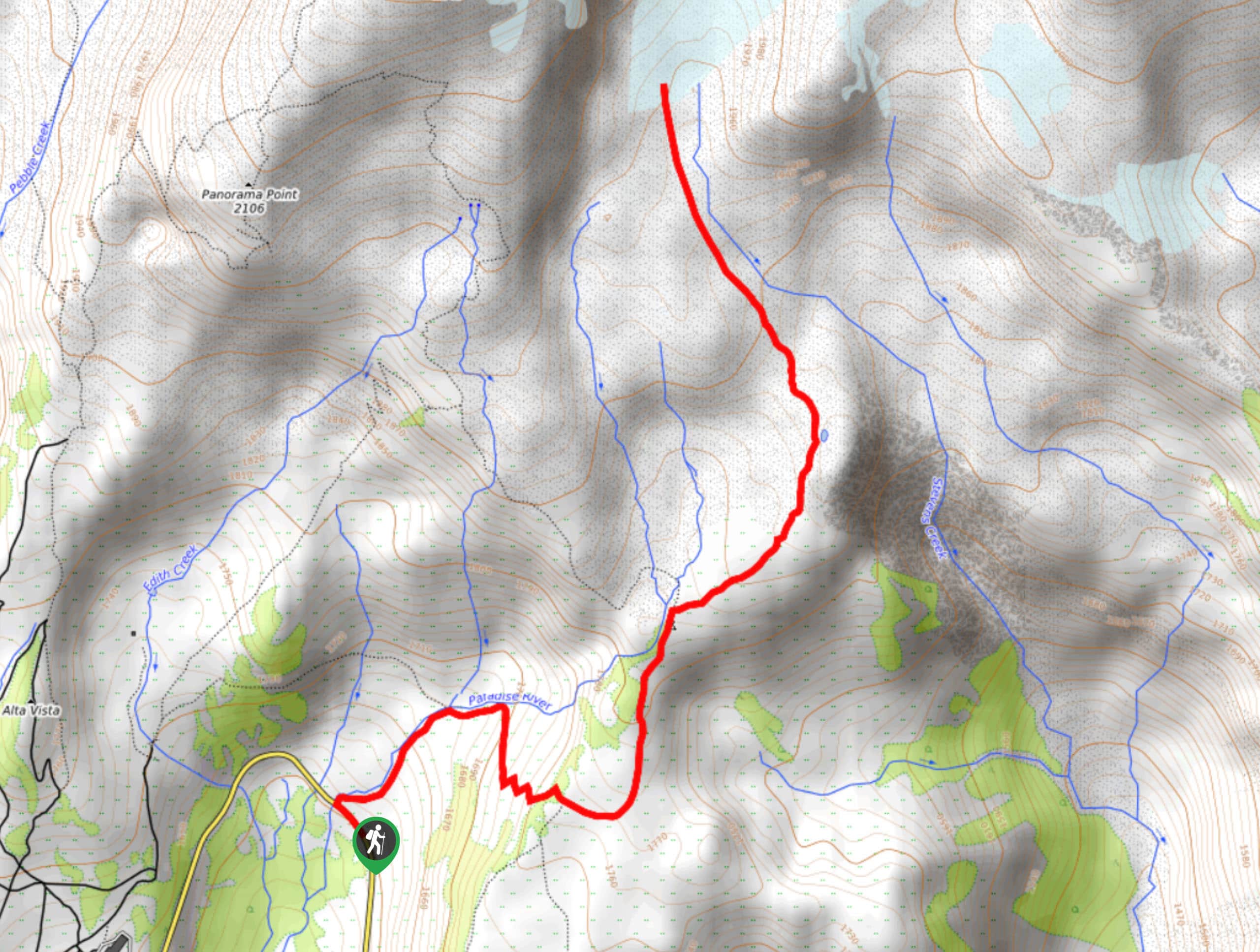
The Paradise Glacier Trail in Mount Rainier National Park is a moderately challenging 10.0mi out-and-back trail that allows you to fully appreciate one of Mount Rainier’s icy glaciers. This trail sees less traffic than others in the park, making it an ideal outing for adventurers who want a medium challenge, solid length, and fantastic views without the crowds.
Getting there
To get to the trailhead for the Paradise Glacier Trail from the Nisqually entrance to the park, drive east on State Route 706 to the Narada Falls View Area parking lot.

About
| Backcountry Campground | No |
| When to do | June-October |
| Pets allowed | No |
| Family friendly | No |
| Route Signage | Average |
| Crowd Levels | Low |
| Route Type | Out and back |
Paradise Glacier Trail
Elevation Graph
Weather
Paradise Glacier Trail Description
For standout glacier views and less traffic than the usual in Mount Rainier National Park, the Paradise Glacier Trail is the one. This moderately challenging 10.0mi trail gives you a perfect view of the southeastern face of Mount Rainier and the (you guessed it) Paradise Glacier.
The trail begins on the steps outside the Paradise Inn. Follow the signs for Myrtle Falls on the Skyline Trail initially. After the falls, stay right at the junction with the Golden Gate Trail. 1.8 miles past the junction, you’ll meet the Paradise Glacier spur trail.
Leave the Skyline Trail and head towards the moraine. You’ll pass a sign marking the end of the maintained trail- head past this and find your way as far as you comfortably can here. The trail peters off a bit at the site of some old ice caves, but if you’re adventurous, you can continue across the rock field to a small waterfall nearby.
After admiring the glacier views, retrace your steps to return. You can also make this a loop hike by taking the Skyline Trail to Paradise Point, which gives you views of Mount Adams, Mount St. Helens, and the Goat Rocks.
Similar hikes to the Paradise Glacier Trail hike

Paul Peak Trail
The Paul Peak Trail is a 6.3mi lightly trafficked out and back trail in Mount Rainier National Park…

Narada Falls to Mazama Ridge Loop
The Narada Falls to Mazama Ridge loop is an 7.4mi moderately trafficked route in Mount Rainier National Park…

Camp Summerland via Wonderland Trail
The hike to Camp Summerland on the Wonderland Trail is a 8.4mi moderately trafficked out and back trail…
Comments