Three Fingers Hike
View Photos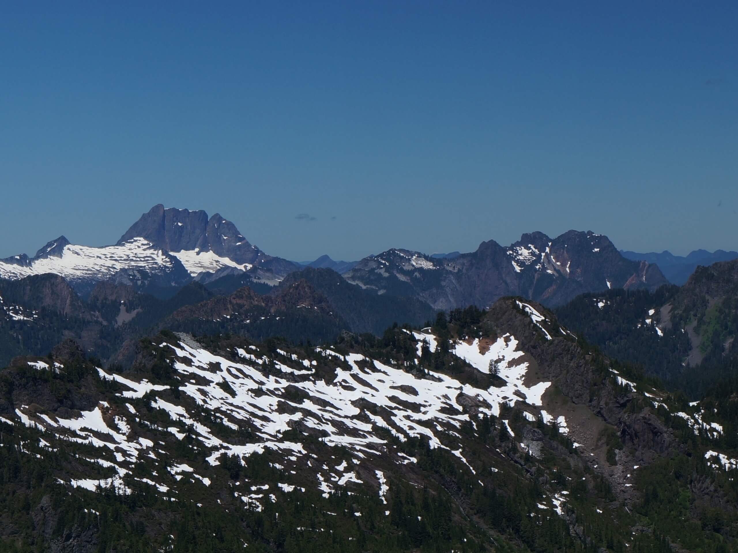
Three Fingers Hike
Difficulty Rating:
The hike to Three Fingers is a 16.0mi lightly trafficked out and back trail in Snohomish county that is rated as difficult. This hike is an epic adventure, but it may be intimidating to some. It’s long, steep, and requires hands-on climbing on exposed rebar ladders to reach the very exposed summit. Casual hikers can turn around before this section, but thrill-seekers will love this out-of-the-box hike.
Please come prepared for this trail and don’t be afraid to turn around if it feels like too much. The mountain will always be there!
Getting there
The trailhead for Three Fingers is off Forest Service Road No. 41. The road is not signed on the highway but watch for a sign about 50 yards down the road. At the junction where the pavement ends, keep left. 17.0mi from the Mountain Loop Highway, the road begins to narrow down before splitting. If you see this, you've gone too far. Stop before the road narrows and look for the trailhead on the left.

About
| Backcountry Campground | Goat Flats |
| When to do | April-October |
| Pets allowed | Yes - On Leash |
| Family friendly | No |
| Route Signage | Average |
| Crowd Levels | Low |
| Route Type | Out and back |
Three Fingers Hike
Elevation Graph
Weather
Three Fingers Trail Description
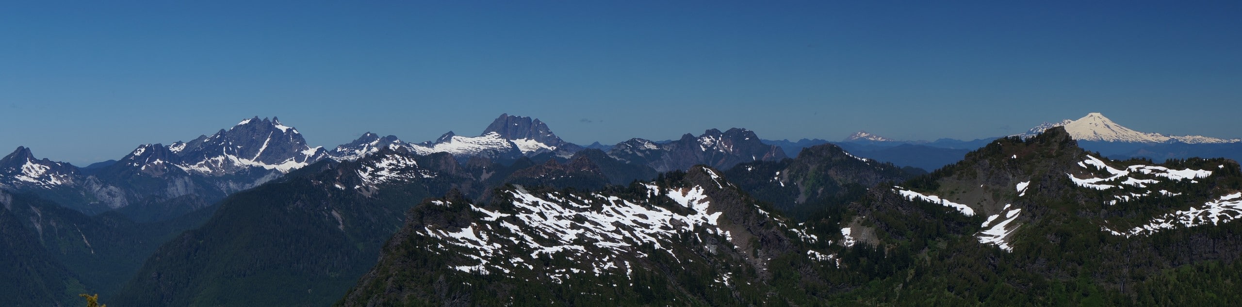
Three Fingers is an epic adventure, climbing high to the three-pointed peak of this lofty mountain. This hike is recommended for strong adventurers who are comfortable with exposure. While there are a few ways to approach this summit, this trail follows the more direct route via Saddle Lake. Be ready for big climbs, ladders, and views unlike any other!
Please bring a reliable map and GPS for this hike and don’t hesitate to turn around if certain sections feel like too much.
The hike begins from the parking area, heading out towards Saddle Lake. The climb is gradual for about 2.5mi, but you should watch for mud, roots, and rocks on this section. If you’re here in the early season, you will likely get wet.
After about a mile, you’ll catch your first glimpse of Three Fingers to your left. Just before Saddle Lake, there is a junction with Meadow Mountain Trail #715. Continue to the lake. Hike around the lake to the northeast side, where the trail begins to approach goat Flats. This open meadow was a popular spot with mountain goats, hence the name. Most of the goats have been moved since.
You’ll reach a junction, with the left trail leading to a small backcountry camping area. This is a good spot to camp if you’d prefer this hike as a backpacking trip. If not, keep to the right and hike 2 miles to Tin Can Gap. Look for the Queest Alb Glacier here. This is normally where casual hikers will turn back, as the ladders and exposed sections are up next.
Conditions through the next section are highly variable depending on the month and the year. You could be walking along rock or climbing a glacier, so evaluate the conditions and proceed based on your comfort level.
You may be traversing the glacier depending on how cold the year’s been, but recently, it’s been shrinking back every year. Past the glacier, you’ll be hiking up rock, heather, and scree. Round the mountain to reach the final snowfield, aiming for the Class II scramble at the top of the snow triangle.
This scramble leads you to the ladders. They’re rebar and wood drilled into the rock, and despite being weathered somewhat heavily, they’re still in good condition, although you may end up with a splinter or two. On top of the rock face, you’ll find a rope left by the Everett Mountaineers to help you get up to the lookout. Use this to aid your final ascent.
Atop Three Fingers, you’ll be able to see everything: the Cascades, the Olympics, Mount Baker, Mount Rainier, Puget Sound, and Glacier Peak. Watch for the resident rat, Andy, who will chew unattended belongings if given the chance. Flip through old summit registers, enjoy your lunch, and take plenty of pictures. Sign the register in the middle of the circular table and make sure it’s put back in the same spot.
You can spend the night up here on a first-come, first-served basis, but if not, carefully descend the rope, the ladder, the scramble, the snowfield, the glacier, and the trail.
Hiking Route Highlights
Mount Rainier
The tallest mountain in the state is a dominant part of your view on the Mount Si Trail. This 14409ft stratovolcano is an iconic sight and the highlight of your view while hiking this route.
Mount Baker
Mount Baker, also known as Koma Kulshan, is a 10781ft glaciated stratovolcano. It’s the second-most thermally active volcano in the Cascade Range after Mount St. Helens.
Frequently Asked Questions
Can you camp on Three Fingers?
You can stay the night in the lookout on a first-come, first-served basis. Please come prepared with everything you need.
Can you camp outside the lookout on Three Fingers?
No, there is no safe place to camp outside of the lookout. If it’s occupied, you can go back and camp at Goat Flats.
What pass do I need for Three Fingers?
You do not need a pass or permit for this hike.
Insider Hints
This lookout is maintained by the Everett Mountaineers on a volunteer basis. Please respect it and the things inside it, taking all your trash with you and tidying up before you leave. If you’d like to volunteer to bring supplies with you, contact the Mountaineers through their website.
The road to the trailhead is subject to washout. Check the conditions and bring a bike if it’s not driveable.
The best conditions on the glacier tend to be in early-mid September, but this depends on the year.
Similar hikes to the Three Fingers Hike hike

Lakes Dorothy, Bear, Deer, and Snoqualmie Hike
The Lakes Dorothy, Bear, Deer, and Snoqualmie Hike provides access to Lake Dorothy, Bear Lake, Deer Lake, and Snoqualmie Lake.…

Gold Creek Trail to Joe Lake
Gold Creek Trail to Joe Lake is not a hike for the faint of heart. This lightly trafficked trail is…

Basin Lake via Bullion Basin Trail
Basin Lake via Bullion Basin Trail is a 12.2mi hike that, with 2900ft of elevation gain,…
Comments