
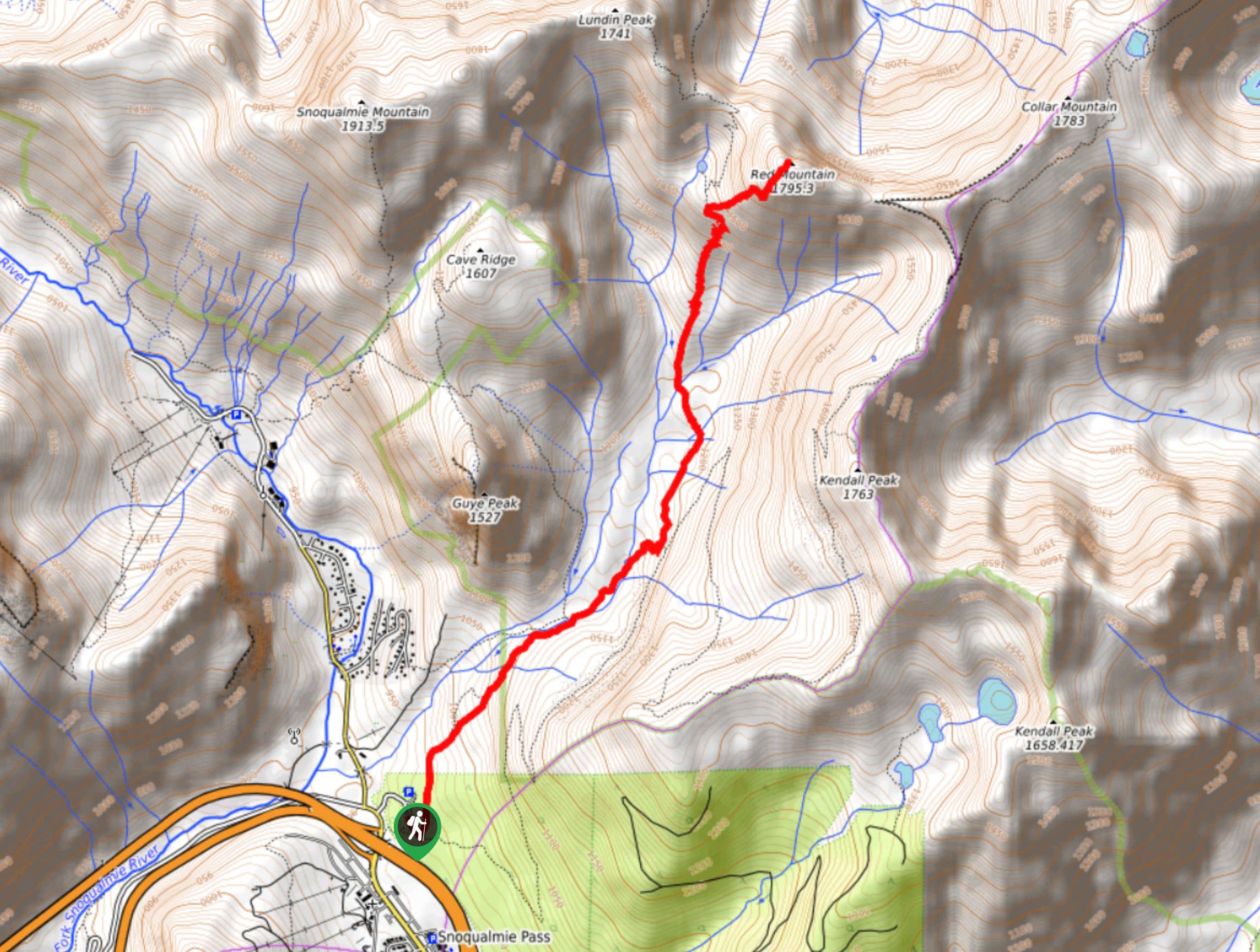
Red Mountain via Old Commonwealth Trail
View Photos
Red Mountain via Old Commonwealth Trail
Difficulty Rating:
Red Mountain via Old Commonwealth Trail is a 5.9mi hard hike in Mount Baker-Snoqualmie National Forest that provides a fun dose of adventure with a scrambling section. Expect several river crossings, great views, and some hard work.
There is some overgrowth at the beginning of this hike, but it’s nothing impassable. We don’t recommend Red Mountain for those who are uncomfortable with heights or exposed scrambles. While dogs are allowed on this trail, we do not recommend trying to bring them up the final mile to the summit as it’s very steep, technical, and rocky.
Getting there
The trailhead for Red Mountain via Old Commonwealth Trail is in Snoqualmie Pass at the PCT trailhead off Alpental Access Road.

About
| Backcountry Campground | No |
| When to do | May-November |
| Pets allowed | Yes - On Leash |
| Family friendly | No |
| Route Signage | Poor |
| Crowd Levels | Moderate |
| Route Type | Out and back |
Red Mountain via Old Commonwealth Trail
Elevation Graph
Weather
Red Mountain via Old Commonwealth Trail Description
Old Commonwealth Trail is a great hike throughout the year, and it provides access to the thrilling ascent of Red Mountain, which involves a sky-high scrambling section. This is a good hike for those comfortable with exposure, heights, and intermediate scrambles.
Begin at the PCT trailhead. The Old Commonwealth Trail split off left from the PCT very quickly—take this. Stay right through two junctions and cross the creek. This first mile or so is quite flat and relaxed, but also deep in thick brush and potentially overgrown.
When you cross Commonwealth Creek, look for a bridge to use to cross and then return to the trail. Head northwest, you’ll merge onto Commonwealth Basin Trail. A handful of stream crossings lead you up to where you’ll begin to climb a bit more aggressively, hiking through very narrow switchbacks.
Stay right at the junction around 4856ft and begin your ascent of Red Mountain. It’s fairly short in terms of distance, but expect the last mile or so to take longer as you navigate the scramble. Some hikers report feeling uncomfortable and turning around before the summit, which is exactly what you do if you feel too far outside of your comfort zone on this section. Otherwise, after enjoying the summit, you’ll retrace your steps back to the trailhead.
Similar hikes to the Red Mountain via Old Commonwealth Trail hike

Lakes Dorothy, Bear, Deer, and Snoqualmie Hike
The Lakes Dorothy, Bear, Deer, and Snoqualmie Hike provides access to Lake Dorothy, Bear Lake, Deer Lake, and Snoqualmie Lake.…

Gold Creek Trail to Joe Lake
Gold Creek Trail to Joe Lake is not a hike for the faint of heart. This lightly trafficked trail is…

Basin Lake via Bullion Basin Trail
Basin Lake via Bullion Basin Trail is a 12.2mi hike that, with 2900ft of elevation gain,…
Comments