
Old Commonwealth Trail
View Photos
Old Commonwealth Trail
Difficulty Rating:
Old Commonwealth Trail is a hard hike in Mount Baker-Snoqualmie National Forest that is used year-round for hiking and snowshoeing. Expect several river crossings, great views, and long talus crossing. This trail used to be longer, but part of it is decommissioned. This guide will only describe the commissioned first section.
There is some overgrowth at the beginning of this hike, but it’s nothing impassable.
Getting there
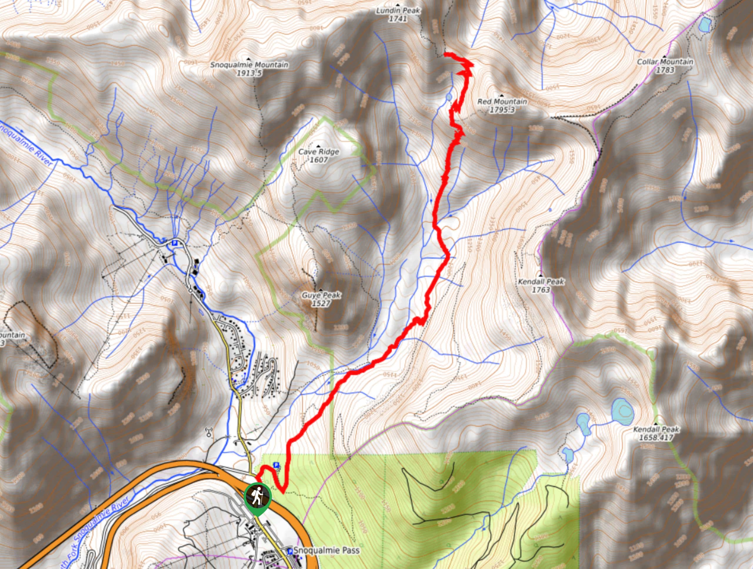
The trailhead for the Old Commonwealth Trail is in Snoqualmie Pass at the PCT trailhead off Alpental Access Road.

About
| Backcountry Campground | No |
| When to do | May-November |
| Pets allowed | Yes - On Leash |
| Family friendly | No |
| Route Signage | Poor |
| Crowd Levels | Low |
| Route Type | Out and back |
Old Commonwealth Trail
Elevation Graph
Weather
Old Commonwealth Trail Description
Old Commonwealth Trail is a great hike throughout the year, although it shines in the summer months. If you come in shoulder season, download your map to guide you through snowy sections where the trail may become difficult to follow.
Begin at the PCT trailhead. The Old Commonwealth Trail splits off left from the PCT very quickly—take this. Stay right through two junctions and cross the creek. This first mile or so is quite flat and relaxed, but also deep in thick brush and potentially overgrown.
When you cross Commonwealth Creek, look for a bridge to use to cross and then return to the trail. Head northwest, you’ll merge onto Commonwealth Basin Trail. A handful of stream crossings lead you up to where you’ll begin to climb a bit more aggressively, hiking through very narrow switchbacks up to Red Pond.
Stay left at the junction around 4856ft and then right at the next (the path to the left just quickly takes you to the shore of the pond). The maintained section of the trail ends shortly after the pond. Here, turn around and retrace your steps to the trailhead.
Similar hikes to the Old Commonwealth Trail hike

Lakes Dorothy, Bear, Deer, and Snoqualmie Hike
The Lakes Dorothy, Bear, Deer, and Snoqualmie Hike provides access to Lake Dorothy, Bear Lake, Deer Lake, and Snoqualmie Lake.…

Gold Creek Trail to Joe Lake
Gold Creek Trail to Joe Lake is not a hike for the faint of heart. This lightly trafficked trail is…

Basin Lake via Bullion Basin Trail
Basin Lake via Bullion Basin Trail is a 12.2mi hike that, with 2900ft of elevation gain,…
Comments