Mud Mountain Rim Trail
View Photos
Mud Mountain Rim Trail
Difficulty Rating:
Mud Mountain Rim Trail is a heavily trafficked out-and-back trail in Mount Baker-Snoqualmie National Forest that is rated as moderate. This hike requires only modest elevation gain and the trail is fairly well-kept, making it a nice choice for newer hikers.
Watch for stinging nettle on the sides of this trail.
Getting there
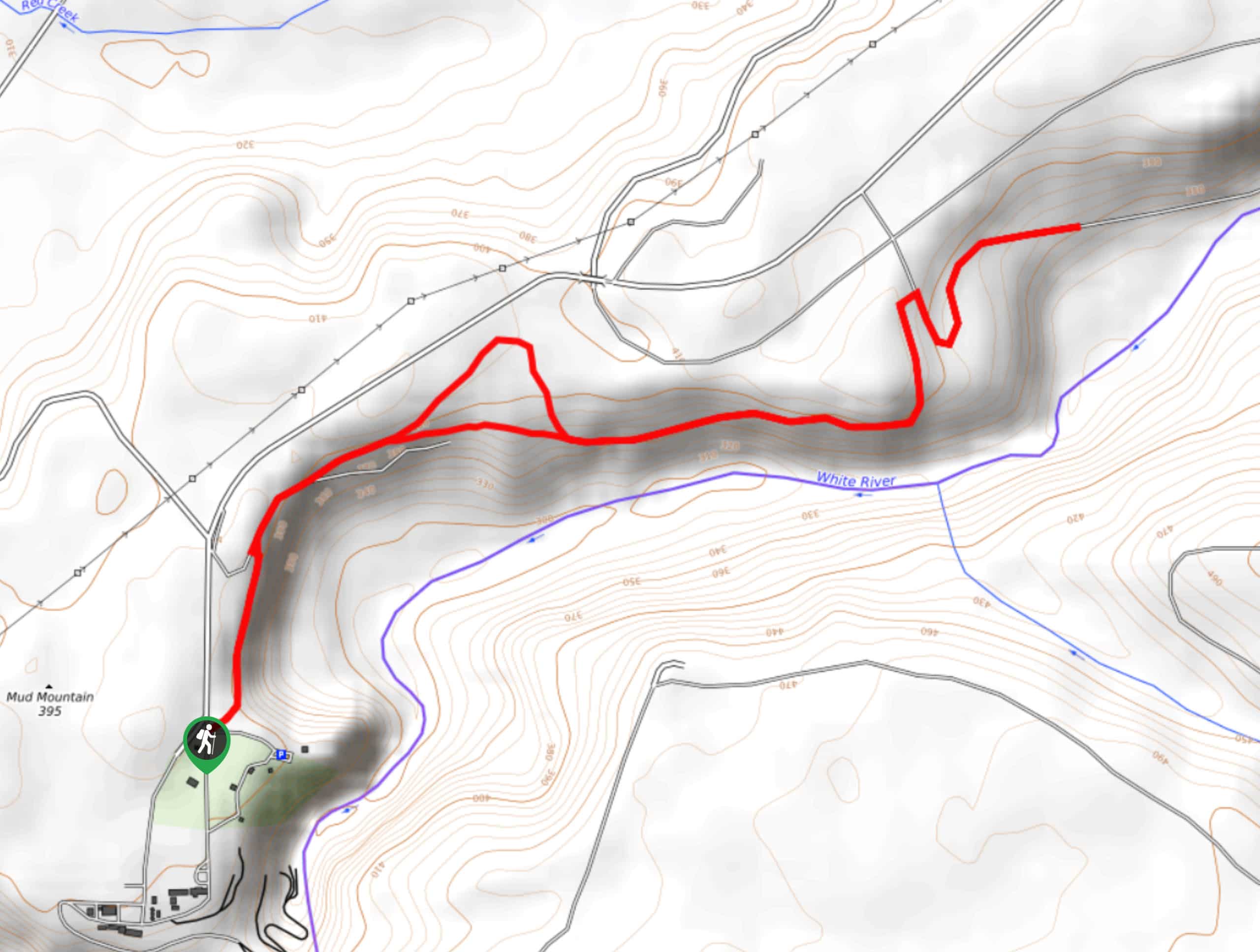
The trailhead for the Mud Mountain Rim Trail is off Mud Mountain Road SE at the north end of the Mud Mountain Dam Recreational Area.

About
| Backcountry Campground | No |
| When to do | Year-round |
| Pets allowed | Yes - On Leash |
| Family friendly | Yes |
| Route Signage | Good |
| Crowd Levels | High |
| Route Type | Out and back |
Mud Mountain Rim Trail
Elevation Graph
Weather
Mud Mountain Rim Trail Description
Mud Mountain Rim Trail is a great outing for newer hikers or a solid choice for shoulder season as the elevation gain is fairly minimal. The hike follows a ridgeline above a creek. Stay on the trail to avoid stinging nettles.
Start your hike by the dam park on the trail adjacent to the fence near the entrance. Walk alongside a pretty forest on the ridge, occasionally crossing over swampy areas with boardwalks.
The main trail eventually connects to a gravel maintenance road that leads closer to the river. On the other side of the valley, you’ll find tall grass and lots of blackberries.
Arriving at Scattered Creek, follow the dry river bed to the river. On the return trip, you’ll have to climb back up the gravelly hill and then retrace your steps to the trailhead.
Similar hikes to the Mud Mountain Rim Trail hike

Lakes Dorothy, Bear, Deer, and Snoqualmie Hike
The Lakes Dorothy, Bear, Deer, and Snoqualmie Hike provides access to Lake Dorothy, Bear Lake, Deer Lake, and Snoqualmie Lake.…

Gold Creek Trail to Joe Lake
Gold Creek Trail to Joe Lake is not a hike for the faint of heart. This lightly trafficked trail is…

Basin Lake via Bullion Basin Trail
Basin Lake via Bullion Basin Trail is a 12.2mi hike that, with 2900ft of elevation gain,…
Comments