Mount Teneriffe via Kamikaze Trail
View Photos
Mount Teneriffe via Kamikaze Trail
Difficulty Rating:
Mount Teneriffe via Kamikaze Trail is a heavily trafficked out-and-back trail that is rated as hard. This hike is a big one, with a straight-up push on a rocky, steep ridgeline required to reach the summit. Teneriffe Falls are a nice stop along the way (when flowing, which tends to be spring and early summer). Come prepared for a big day!
Getting there
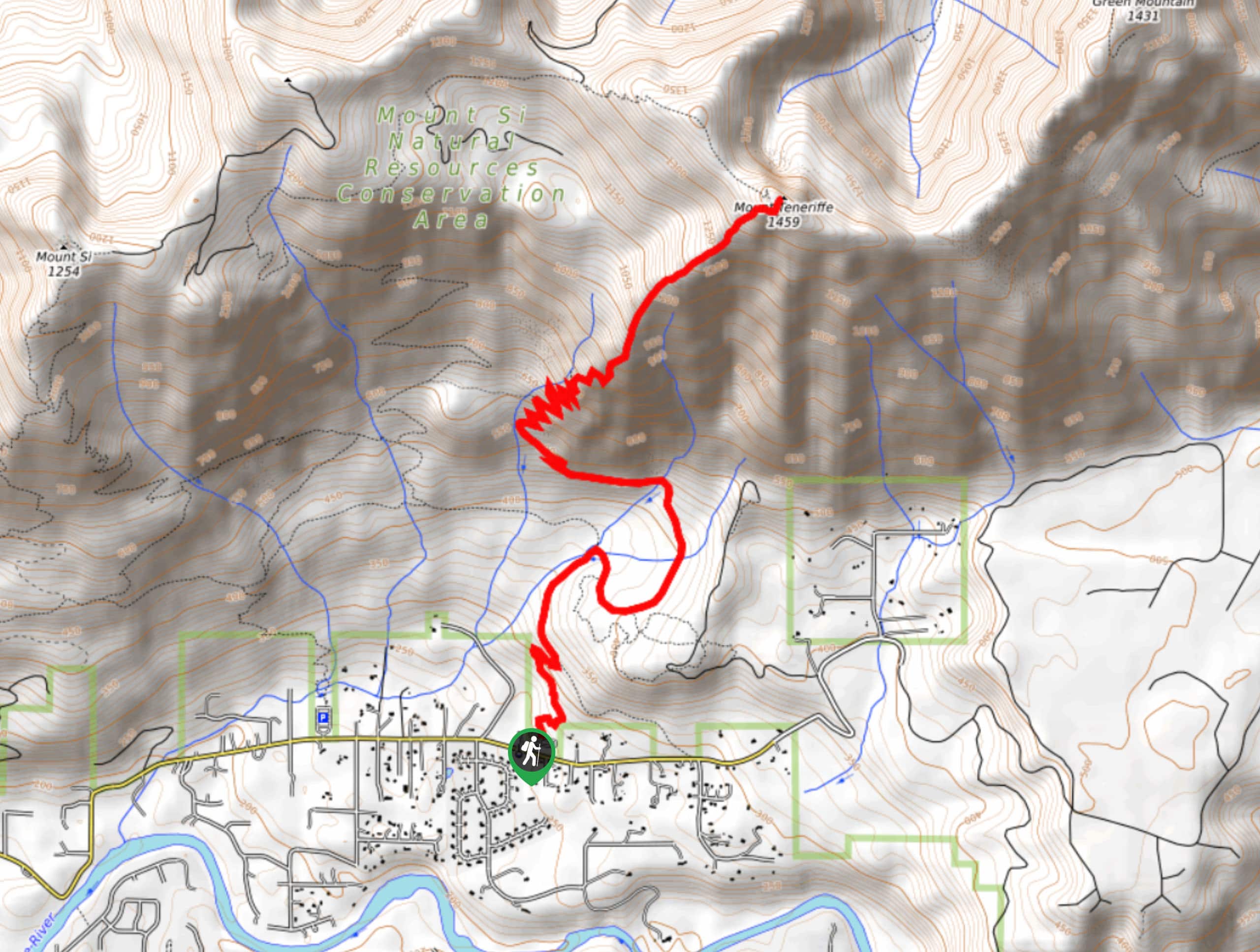
The trailhead for Mount Teneriffe Trail is off SE Mount Si Road. After 3.0mi there is a large paved parking area on the left.

About
| Backcountry Campground | No |
| When to do | May-October |
| Pets allowed | Yes - On Leash |
| Family friendly | No |
| Route Signage | Poor |
| Crowd Levels | High |
| Route Type | Out and back |
Mount Teneriffe via Kamikaze Trail
Elevation Graph
Weather
Mount Teneriffe via Kamikaze Trail Description
The hike up Mount Teneriffe on Kamikaze Trail is no small task, but you’ll be happy you did the work to discover the views! This is a steep, hard trail, so we recommend coming in good weather and bringing poles if you have them.
From the parking lot, take the 0.6mi access trail and turn left on the old logging road. This road quickly narrows to a trail. After 0.4mi on this trail, look for the Teneriffe Falls signage and follow it. This recently improved trail follows switchbacks in and out of a talus field until it reaches Kamikaze Trail.
Just before reaching the falls, look for a climber’s trail to the right. You’ll backtrack to this after checking out the falls. Follow this trail as it climbs 400ft to a saddle and go left to ascend directly up the ridge. The trail heads to hiker’s left through a meadow and a rock band. After passing through a last stand of trees, take a short scramble to reach the summit.
On the way down, carefully descend the scramble and then make your way to the trailhead via the same path.
Similar hikes to the Mount Teneriffe via Kamikaze Trail hike

Lakes Dorothy, Bear, Deer, and Snoqualmie Hike
The Lakes Dorothy, Bear, Deer, and Snoqualmie Hike provides access to Lake Dorothy, Bear Lake, Deer Lake, and Snoqualmie Lake.…

Gold Creek Trail to Joe Lake
Gold Creek Trail to Joe Lake is not a hike for the faint of heart. This lightly trafficked trail is…

Basin Lake via Bullion Basin Trail
Basin Lake via Bullion Basin Trail is a 12.2mi hike that, with 2900ft of elevation gain,…
Comments