
Lime Kiln Trail
View Photos
Lime Kiln Trail
Difficulty Rating:
Lime Kiln Trail is a 6.7mi heavily trafficked out and back trail in Washington that is rated as moderate. This trail is very unique; you won’t be seeing sprawling mountain vistas, but you will be finding hints of the area’s history hidden in a mossy river canyon. The hike features an old kiln used to make lime from limestone, and a few artifacts from a long-gone railroad and community remain. The river canyon itself is very pretty, with lush greenery surrounding the calm waters. For a break from the usual, this is a great hike.
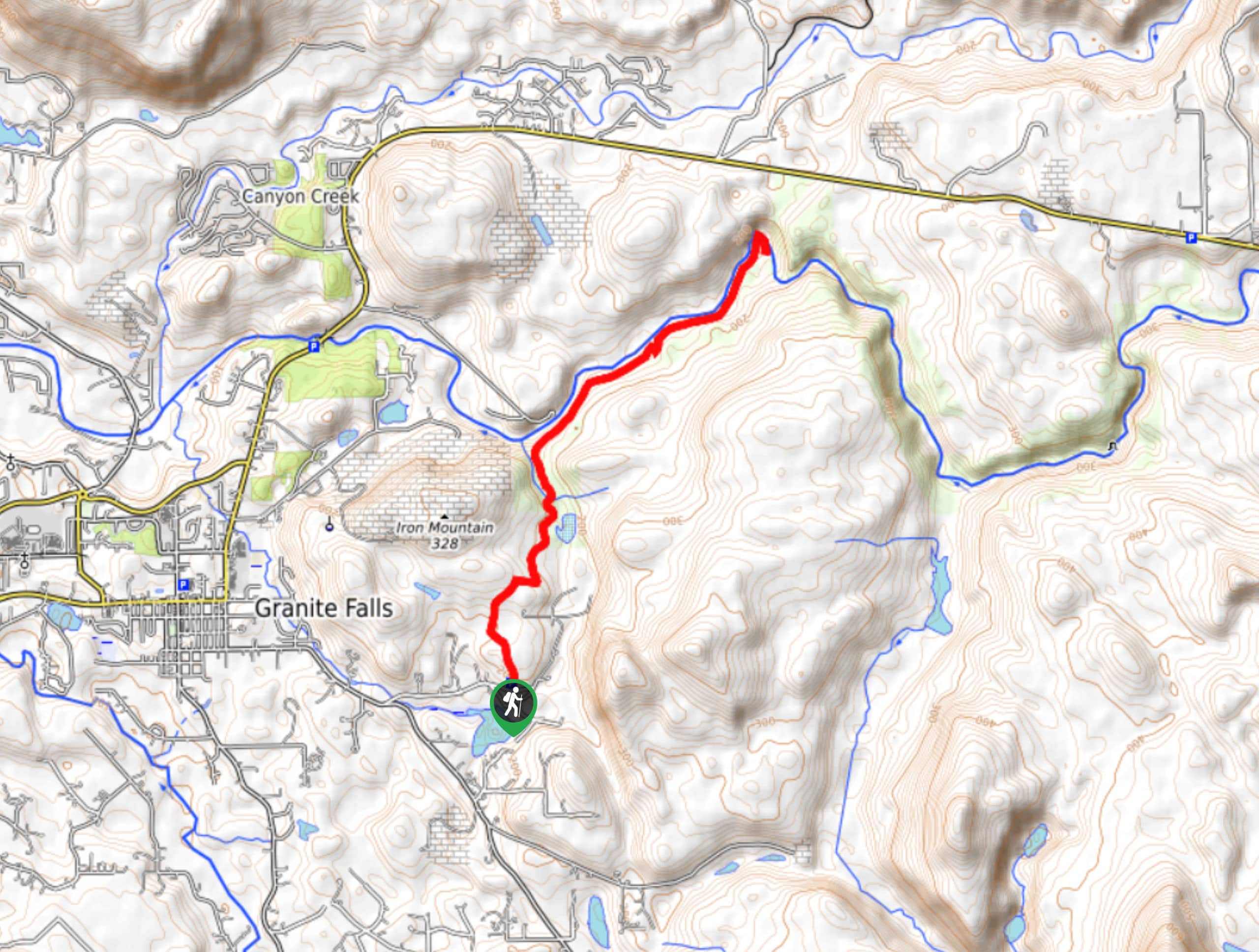
Getting there
The trailhead for Lime Kiln Trail is on Waite Mill Road in the Robe Canyon Historic Park at the signed parking area.

About
| Backcountry Campground | No |
| When to do | March-November |
| Pets allowed | Yes - On Leash |
| Family friendly | Yes |
| Route Signage | Good |
| Crowd Levels | High |
| Route Type | Out and back |
Lime Kiln Trail
Elevation Graph
Weather
Lime Kiln Trail Description
Lime Kiln Trail is a hike quite unlike most others. What you might lack in traditional mountain views is made up by historical artifacts that tell the story of the Robe Canyon Historic Park. As a former site of lime production, a lime kiln still stands on the trail. This region also held several small communities and a railroad, both of which are gone, but you can find small artifacts from each if you’ve got a keen eye! The trail travels through a mossy forest along the river canyon, which is wonderfully tranquil. This hike is moderate, with fairly little elevation gain to contend with over its 7.0mi.
Some of this trail crosses through private property, so please stay on the designated route.
The hike begins from the parking lot in the Robe Canyon Historic Park. Take a moment to check out the bulletin board at the trailhead, which offers photos and information about the park.
Start with a gentle 200ft of elevation gain, then descend 600ft to a level trail that follows the old railroad grade. Hike through the forest, packed full of moss and ferns. Briefly coming out of the forest, you’ll hike along an old road on private property. Leave the road to hike down a stony pathway near Hubbard Pond.
Cross a bridge and hike along another old road. Turn left and hike downhill (you’ll probably realize by now that most of the elevation gain on this hike happens on the way back). Listen for the creek as you hike towards the South Fork of the Stillaguamish, where you’ll rejoin the old railroad grade.
Along this stretch, there are interpretive signs that offer more information on the area’s history and past use. You can learn about the railways that ran through here, the communities, and the logging operations that used to take place. Watch for artifacts along the trail, including old bricks, a portion of a cast-iron stove, saw blades, and more. Remember not to touch or take, as future hikers will want to enjoy these too.
The trail ascends a side canyon and crosses over. Shortly after this, the lime kiln appears on your right just off the trail. It’s close to 20ft tall and quite impressive at first glance! It was constructed in the 1890s and used for about 40 years. Take a peek into the stoking ports on the side.
Further on, you’ll follow a railroad grade for 0.7mi. Watch for a sign that tells you to go left for the 0.2mi River Shore Loop or right for the end of the trail. While this might seem like a one or the other choice, the two trails actually form a loop, so you can take either. At the end of the loop is a short side trail that leads to where the former railroad bridge was. Nothing remains of the bridge, but the river is a nice view.
Near the end of the trail you can access the water, which will likely have a tiny bit of beach exposed in the summer. In the winter or spring, the water can flow very fast, so take care of your pets or children.
To return to the lot, you’ll retrace your steps.
Hiking Route Highlights
Limestone Kiln
Lime, or calcium oxide, was made from limestone in the trail’s kiln until the 1930s. Lime was used as a “flux” to help melt ore in smelters near Everett. This lime was transported on the surrounding railroads. Carts of limestone were loaded into the kiln and fires burned within. The kiln today looks like an ancient ruin with its cloak of moss and ferns.
Frequently Asked Questions
Do I need a pass for Lime Kiln Trail?
No, this trail does not currently require any pass or permit.
Is Lime Kiln Trail dog friendly?
Yes, the trail is dog-friendly. Dogs should be kept on leash and care should be taken near the river when the water levels are high.
Insider Hints
This hike can be completed year-round in good conditions.
Wild blackberries grow along the trail in the summertime, and they make for a tasty snack!
Similar hikes to the Lime Kiln Trail hike

Lakes Dorothy, Bear, Deer, and Snoqualmie Hike
The Lakes Dorothy, Bear, Deer, and Snoqualmie Hike provides access to Lake Dorothy, Bear Lake, Deer Lake, and Snoqualmie Lake.…

Gold Creek Trail to Joe Lake
Gold Creek Trail to Joe Lake is not a hike for the faint of heart. This lightly trafficked trail is…

Basin Lake via Bullion Basin Trail
Basin Lake via Bullion Basin Trail is a 12.2mi hike that, with 2900ft of elevation gain,…
Comments