Kendall Katwalk Trail
View Photos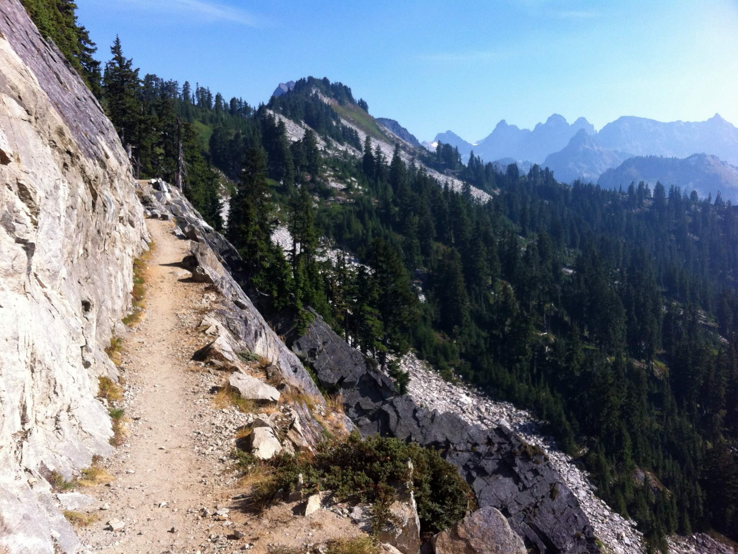
Kendall Katwalk Trail
Difficulty Rating:
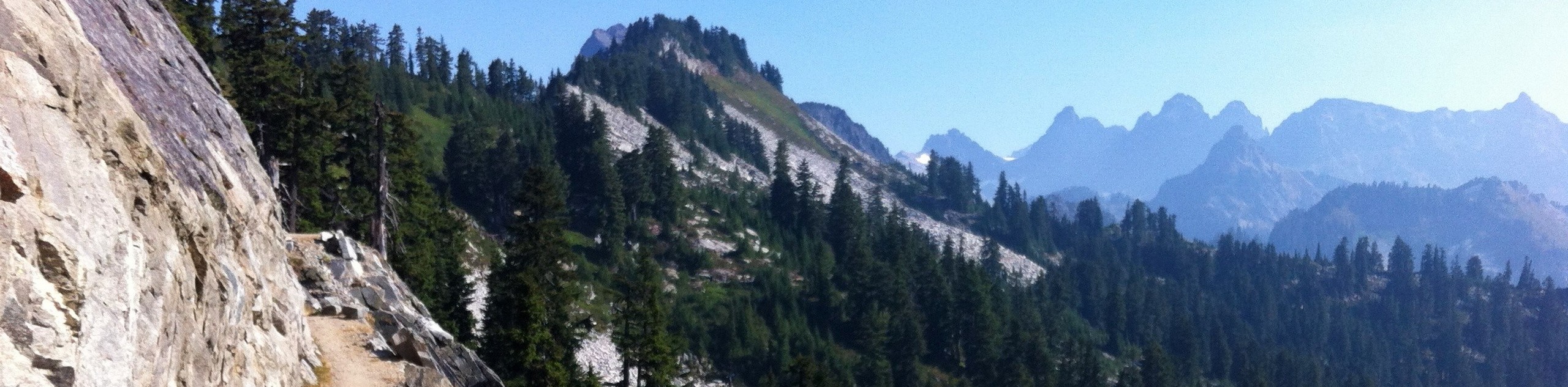
Kendall Katwalk Trail is a 15.0mi heavily trafficked out and back trail in Mount Baker-Snoqualmie National Forest that is rated as hard. This trail is a full-day affair, but it’s one you’ll want to come back to over and over. Kendall Katwlak itself is a narrow trail blasted into a steep rock face underneath Kendall Peak. While it’s not for those afraid of heights, it’s a spectacular vantage point over the field of summits beyond. With a good bit of distance to cover and fair elevation to climb, you’ll feel like you worked for your views.
There is camping available at Ridge Lake just beyond the catwalk if you want to make this a backpacking excursion.
Getting there
The trailhead for the Kendall Katwalk Trail is off I-90 and Erte Strasse at the PCT parking lot.

About
| Backcountry Campground | Ridge Lake Backcountry |
| When to do | June-September |
| Pets allowed | Yes - On Leash |
| Family friendly | No |
| Route Signage | Good |
| Crowd Levels | High |
| Route Type | Out and back |
Kendall Katwalk Trail
Elevation Graph
Weather
Kendall Katwalk Trail Description
Kendall Katwalk Trail is an undeniably impressive hike. This 12.0mi trail climbs a catwalk (er, katwalk) blasted onto the side of a mountain for unbelievable views of Gold Creek Valley and the Alpine Lakes Wilderness. While it’s not a good choice for those who are afraid of heights or dislike narrow, exposed trails, it’s a favorite for adrenaline junkies and hikers perpetually on the hunt for the next-best views. The trail will make you work for it, but the 2600ft of elevation gain is spread out somewhat gradually, making it doable for many intermediate and better hikers.
This trail is a hotspot for wasps and hornets, and hikers and dogs both get stung somewhat regularly. Be careful!
The trail begins on the PCT. At the T-junction, stay right. Hike for 100ft, passing a gravelly trail on the left to stay straight. The path is wide and well-kept and is lined by wildflowers in the summertime and blueberries in the late summer. You’ll hike through several wide winding turns before straightening out.
About 2.0mi in, you’ll enter a talus field, dropping some elevation. A 0.3mi later, a little waterfall can be seen. There are two stream crossings ahead. While the crossings are usually easy enough, they can be a bit daunting in high water. If it seems like too much for you, turn around and return another day.
A junction appears 500ft later, and you’ll stay right here. Beginning to switchback through the forest, you’ll cross the stream once more before hiking through a gravel runoff bed into a rock formation. Note that the trail becomes hard to find here- you’ll want to watch for a sharp right turn.
Hike into an old-growth forest. 4.3mi in, you’ll hike over a flat ridgetop, then climb onto a steep hillside. The forest here is gorgeous, but you’ll leave it as you cross over an open talus slope. This area is known as the Kendall Gardens for its resplendent wildflowers in the summertime.
The trail through the gardens and beyond becomes quite steep and rocky, and the first taste of exposure comes. Take it slow if you need to. Look behind you for views of Mount Rainier before making a right turn on the trail to begin hiking east.
The final 0.5mi is undulating, clinging to the side of the mountain. This section of the trail is stellar, but it’s not as safe in the snow, so take care in poor conditions. The views are wide and impressive here.
Crossing the pass below Kendall Peak, the narrowest section of the trail comes next. If you’re already feeling exposed enough, feel free to leave this for another time. If you’re wanting to see more, it’s a short jaunt to the end of the catwalk.
Most hikers choose to continue from here to Gravel and Ridge lakes, which are 1.3mi further. These lakes offer a nice place to cool off, swim, dip your feet, or otherwise relax before making the return trip to the trailhead. Whether you choose to continue to the lakes or not, you’ll be retracing your steps to the parking lot when you’re ready to return.
Hiking Route Highlights
Alpine Lakes Wilderness Area
The star of the view on Kendall Katwalk is the Alpine Lakes Wilderness, a large wilderness area spanning the Central Cascades of Washington state. Established in 1976 and managed by the United States Forest Service, this pristine region is home to more peaks, lakes, and wildflower meadows than you could count. It’s a stunning area to explore!
Frequently Asked Questions
How high is Kendall Katwalk?
The highest point of the trail is 5400ft.
Can you hike Kendall Katwalk in the winter?
This trail is best used between June and September. Portions of the route become unsafe in slippery or snowy conditions, so we recommend visiting exclusively in the summertime.
Do I need a permit for Kendall Katwalk?
Yes. Please have your Northwest Forest Pass ready.
Insider Hints
Bring poles for the creek crossings.
Equestrians frequent this trail. Remember to give horses the right of way.
Similar hikes to the Kendall Katwalk Trail hike

Lakes Dorothy, Bear, Deer, and Snoqualmie Hike
The Lakes Dorothy, Bear, Deer, and Snoqualmie Hike provides access to Lake Dorothy, Bear Lake, Deer Lake, and Snoqualmie Lake.…

Gold Creek Trail to Joe Lake
Gold Creek Trail to Joe Lake is not a hike for the faint of heart. This lightly trafficked trail is…

Basin Lake via Bullion Basin Trail
Basin Lake via Bullion Basin Trail is a 12.2mi hike that, with 2900ft of elevation gain,…
Comments