Blanca Lake Trail
View Photos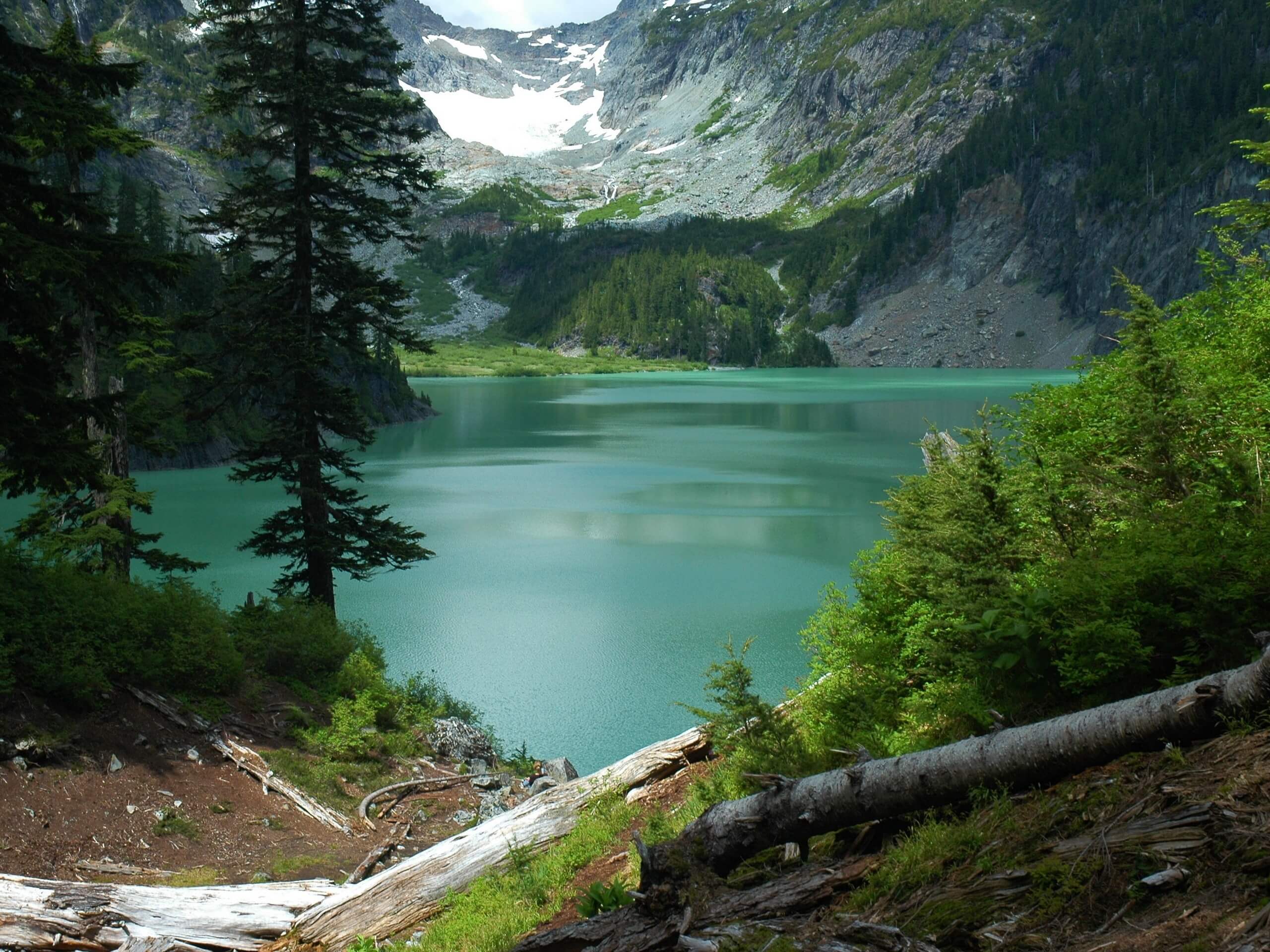
Blanca Lake Trail
Difficulty Rating:
The Blanca Lake Trail is a 8.1mi heavily trafficked out and back trail in the Henry M. Jackson Wilderness that is rated as hard. This trail requires that you climb 30 or so steep switchbacks, but the aqua-green waters of Blanca are framed by Monte Cristo, Columbia, and Keyes peaks. The views on the way up don’t disappoint, either! With peeks of Columbia Peak guiding you up, you should be at least partially distracted from the effort required.
This trail is sometimes rocky, rooty, or muddy (despite continual efforts by the WTA), so good boots and poles are very helpful. The road to the trail has its fair share of potholes, so drive carefully. Additionally, the parking lot here only has room for about 20 cars, and this is a very popular hike. We strongly recommend arriving early on a weekend or hiking on a weekday if you can.
Getting there
The trailhead for the hike to Blanca Lake is on a spur road off FR 63. From the junction of FR 63 and Garland Mineral Springs Road, take a right onto FR 63 and drive for about 2.0mi. Take the spur road to the left over another small hill.

About
| Backcountry Campground | Virgin Lake |
| When to do | June-October |
| Pets allowed | Yes - On Leash |
| Family friendly | No |
| Route Signage | Average |
| Crowd Levels | High |
| Route Type | Out and back |
Blanca Lake Trail
Elevation Graph
Weather
Blanca Lake Trail Description
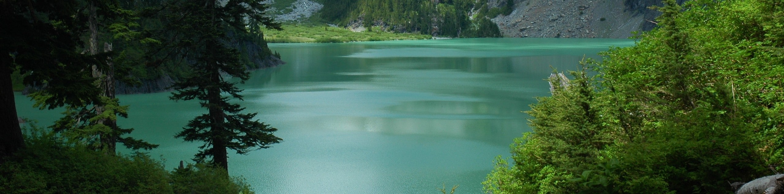
Blanca Lake is mesmerizing, with that classic alpine opaque aqua-green color (thanks to the minerals in the water) and a grand frame of mountains behind it, including Monte Cristo, Columbia, and Keyes mountains. It’s a pristine spot that draws plenty of hikers, but to get there, you’ll need to contend with lots and lots of steep switchbacks. Thankfully, the elevation gain is spread out well over the entirety of the hike, so intermediate hikers and better should be able to enjoy this hike.
Note that portions of the route are sometimes muddy or rocky, so good boots are helpful. Take care on the drive up as well- while the road isn’t nearly as bad as some other mountain roads, it’s got numerous potholes to avoid.
The trail begins in a second-growth forest, nearly immediately beginning to climb. The switchbacks in this section are nicely maintained, making gaining almost 3000 feet in almost 3 miles a bit more bearable.
Keep climbing, grabbing handfuls of huckleberries off the side of the trail. About 3 miles in, the trail reaches a ridgeline. You’ll take more switchbacks up this ridge, which has nice views of Glacier Peak on clear days.
The trail evens out once you’re over the ridgeline, passing through sub-alpine meadows. You’ll pass little Virgin Lake, which marks the beginning of the section of trail that can be a bit less smooth, especially when it’s rained recently. Thanks to trail conservation crews, it’s nothing too bad, but just watch for mud, puddles, and roots as you drop some elevation.
The view of the lake opens up here, a stunning sight! The Columbia Glacier drains into the lake, the two waterfalls flowing down into the bright blue pool. The trail ends at a beach full of driftwood, which is the perfect spot to sit and soak up the scenery.
When you’re ready, turn around and retrace your steps, remembering that there’s a small climb to complete where you dropped down near the end of the hike.
Hiking Route Highlights
Blanca Lake
The Columbia Glacier-fed Blanca Lake is an enchanting sight, with the unique opaque blue-green waters so often associated with mountain lakes. This lake is situated in a basin, surrounded by the mountains of the Cascade Range. The glacial till (sediment) gives Blanca Lake its wonderful color.
Frequently Asked Questions
Do I need a pass to hike to Blanca Lake?
Yes, please have your Northwest Forest Pass ready. You can purchase one if you don’t currently have one.
Can I swim in Blanca Lake?
You’re allowed to swim in Blanca Lake, but the water does tend to be chilly since it’s glacier-fed.
Why is Blanca Lake so blue?
It’s all that silt-filled glacial meltwater that makes Blanca Lake so blue!
Insider Hints
Parking for this trail fills up quickly on the weekends. Get here early!
If parking is full, the nearby West Cady Ridge is a pleasant hike and only 3.0mi down the road.
There are toilets at both the trailhead and Virgin Lake.
Similar hikes to the Blanca Lake Trail hike

Lakes Dorothy, Bear, Deer, and Snoqualmie Hike
The Lakes Dorothy, Bear, Deer, and Snoqualmie Hike provides access to Lake Dorothy, Bear Lake, Deer Lake, and Snoqualmie Lake.…

Gold Creek Trail to Joe Lake
Gold Creek Trail to Joe Lake is not a hike for the faint of heart. This lightly trafficked trail is…

Basin Lake via Bullion Basin Trail
Basin Lake via Bullion Basin Trail is a 12.2mi hike that, with 2900ft of elevation gain,…
Comments