
Sky Meadows Trail
View Photos
Sky Meadows Trail
Difficulty Rating:
The Sky Meadows Trail is a great route for beginner hikers and families with younger children. Ending at a sublime alpine meadow, the route is not excessively long. Taking you alongside beautiful lakes and charming creeks, the Sky Meadows Trail is regarded as an excellent wildlife viewing route.
Getting there
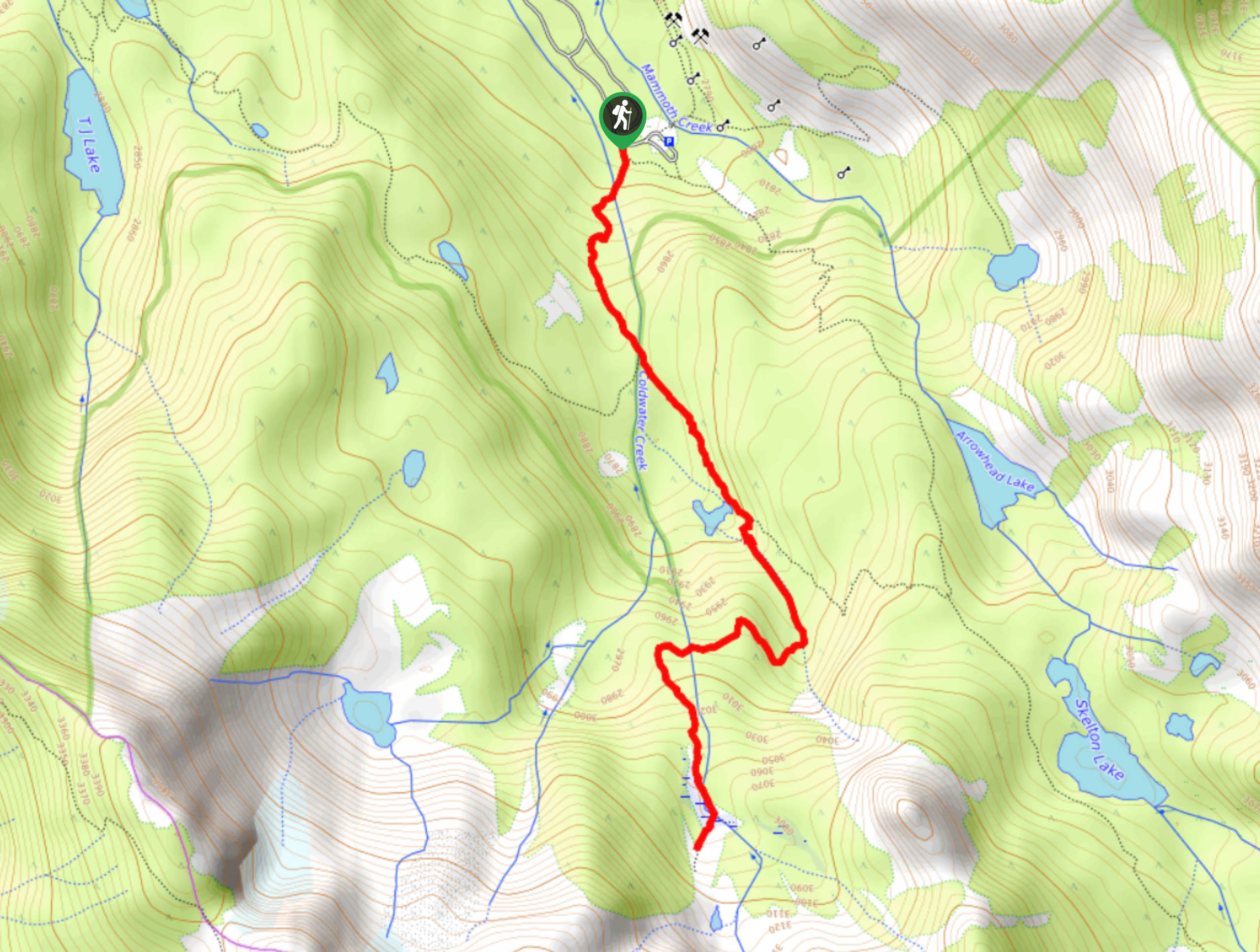
The trailhead for Sky Meadows Trail is located off of Coldwater Creek Campground Road.

About
| Backcountry Campground | |
| When to do | April-October |
| Pets allowed | Yes - On Leash |
| Family friendly | Yes |
| Route Signage | Average |
| Crowd Levels | Moderate |
| Route Type | Out and back |
Sky Meadows Trail
Elevation Graph
Weather
Sky Meadows Trail Description
Depending on the time of year that you do the Sky Meadows Trail, the mosquitoes can be rather prolific. As such, it is recommended that you bring bug spray and wear pants and long sleeves. The pathway for the Sky Meadows Trail can likewise be difficult to follow after fresh snowfall. So if you are planning on doing the route later in the season, a mapping tool is recommended.
Having reached the trailhead, follow the Emerald Lake Trail south as it steadily inclines in elevation. Follow Emerald Lake Trail south all the way to Emerald Lake itself before taking the western pathway at the trail junction. Follow this pathway alongside a creek until the trail veers sharply to the west. Having crossed another creek, the trail will again veer sharply to the south and after a few hundred feet of walking, you will arrive at Sky Meadows. After you have had an opportunity to enjoy the views, simply backtrack your steps towards the trailhead.
Similar hikes to the Sky Meadows Trail hike

Valentine Lake Trail
An underrated route within Inyo National Forest, Valentine Lake Trail is without a doubt worth the effort! Boasting sublime scenery…

Mountain View and 3S89 Road Loop
Mountain View and 3S89 Road Loop is a delightful route within Inyo National Forest. Leading you through a lovely forested…
Dinosaur Falls Trail
Dinosaur Falls Trail is a beautiful route within Inyo National Forest. Easily accessible, the route is ideal for families with…
Comments